
NOAA dropped 41 tide gauges after the year 2010. Apparently they weren’t cooperating with the agenda.
The tide gauges they dropped averaged 0.66 mm/year of declining sea level, and all but two were below the 100% fraudulent NASA/CU claim of +3.3 mm/year.
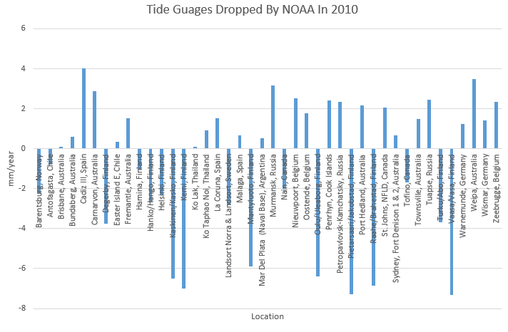
The sea level scam is every bit as fraudulent as all of the other government climate scams.

I notice that 8 of those dropped are from Australia. Two being capital cities including Fort Denison in Sydney Harbour. Absolutely bizarre
That’s right in there with Church and White.There are 1250 or so tide gauges in The Permanent Service for Mean Sea Level, and Church and White used only 500 or so in their papers. Guess how the average sea level of those they kept compared to those they tossed out?
When I get home tomorrow I will be checking this one out.
Thanks for the post.
Reply
But they added a 2nd Galveston gauge (>6 mm/yr):
Original:
http://tidesandcurrents.noaa.gov/sltrends/sltrends_station.shtml?stnid=8771450
Added:
http://tidesandcurrents.noaa.gov/sltrends/sltrends_station.shtml?stnid=8771510
Galveston is built on fill-dirt, which is slowly settling. 3/4 of the sea-level rise measured at Galveston is due to the land sinking, rather than the Gulf of Mexico rising. But even at Galveston, sea-level is only rising at a rate of about one foot per 50 years, or 1/10 Hansen’s absurd projection of 10′ by 2065.
https://www.youtube.com/watch?v=6DexSKxY2Nc
Great video. Thanks for sharing.
Speaking of Galveston. That place and the greatest natural disaster in US history came to mind when I read this little piece of pure propaganda fantasy bull hockey linked at that most reliable news source The Huffington Post! http://www.businessinsider.com/devastating-gray-swan-hurricane-could-hit-tampa-2015-9
Ever heard of the movement of continental plates, land subsidence and bad foundations on piers etc.? It is more difficult to come up with structural failures that cause the instruments to be lifted up in the air, isn’t it?
Movement of continental plates goes both ways. Lifted up in the air in Finland, sinking in Italy. Drop all the tide gauges in Finland and none in Italy and it’s fraud, isn’t it?
Why don’t you skeptics check what is the reason for dropping of the tide-gauges? Movement of the ground and structures is being tracked with GPS and satellite radar. Not removing unstable gauges would be fraud, would it not?
Idiot. Unstable gauges would be falling. Finland is rising. They remove all rising gauges and leave all sinking ones. How can you be so stupid?
Perhaps you should Check..
Goddard lists 41 Tide Gages above.. Gages which were dropped.. Gages which DON’T support big sea level rise..
The Trick is simple.. exclude the data which doesn’t support your Thesis … or Funding.. Get F’ing Real cfgid!!
Don’t listen to #AGWstooges morons!
More on sea level rise crap:
http://wp.me/p5UsvC-2J
https://www.pinterest.com/jcmirre/co2gasoflife/
Juan Mirre is the real deal and you should heed his words. Thanks Juan.
Wow cfgjd, that’s quite a stretch.
Normal, thinking people recognize that the sea is not rising at an precipitous rate, otherwise we’d be able to SEE it. I regularly talk to people who live on both coasts of Canada, all of whom say the sea level is indistinguishable from where it was 40, 50, 60 years ago. NONE of them say, “yeah, it’s rising”. None.
Skeptics know all about the fact that some land is rising and some is sinking. It appears that “climate scientists” are unaware of this, just as they appear to be completely blind to the glaciers that are growing, and somehow only see the ones that are retreating.
Better to use satellites thanks to vastly superior sampling of ocean basins. Recently the rise has been quicker and there absolutely no “hiatus”, which is a hoax:
http://www.aviso.altimetry.fr/fileadmin/images/data/Products/indic/msl/MSL_Serie_MERGED_Global_IB_RWT_GIA_Adjust.png
You have a remarkably inert mind.
Denialists hate data. Data must be denied. Ha ha
The only reaction is when you hurry to provide the proof.
Could we seen ‘unadjusted’ Satellite Data??
The Error Rate.. for GRACE is 100 times what they claim to measure.. measuring Sea Level via Satellite is incredibly complex.. ripe with Fraud and assumptions injected..
You’re the Denialist here.. Goddard and everyone else present your with ACTUAL OBSERVATIONS.. you reply with models, adjusted data..
There is nothing wrong with the satellites. The problem is the human criminals tampering with the satellite data.
In other words, according to you a global conspiracy has somehow tampered data from satellites coming from multiple nations and space agencies? Obviously you can deny any inconvenient data by evoking such a secret conspiracy -> you’re a textbook denialist.
Unable to respond to specific data tampering claims, you resort to generic attacks and platitudes. As I said, a remarkably inert mind. A primitive program could generate the same responses and nobody could tell the difference between its output and yours. Do you even exist?
Let’s go back to the Tide Gages.. you immediatly ignore what was presented.. move on to Satellites..
WHY does NOAA EXCLUDE those Gages?? .. but keeps dirt fill Galveston?? Shouldn’t they be put back in.. don’t you want to know THE TRUTH about Sea Level??
Adjustments galore. Went looking for accuracy and just what they are able to measure after a post of Bob’s Dec, 2014 and had a real awakening. Seems that overall measuring of ‘sea surface’ has problems. Original bucket & thermometer (no depth control), ship intake (well below surface and varied depth due to load +/-20 feet), buoys (seem to rock in the wave with depth resolution of a meter), then IR satellite (cannot get thru the clouds) to microwave (get thru the clouds, but not the rain & surface mist). Oh and did I mention one of the satellites was doing reasonable until they had to boost the altitude, then had problems with pitch, yaw and just had no idea the height it was flying. The number of adjustments to correct is staggering. Includes (but not limited to); wind speed, rain, cloud amount/percent and cloud water vapor, daytime diurnal warming, high latitudes, aerosols, SSTs <10C, columnar water vapor, higher latitudes show a slight warm bias, seasonal cycle wind direction for SST retrieval, fast moving storms and fronts, wind direction error and instrument degradation.
http://images.remss.com/papers/rsspubs/gentemann_jgr_2014.pdf
Still their abstract reads –
Errors were identified in both the MW and IR SST data sets: (1) at low atmospheric water vapor a posthoc correction added to AMSR-E was incorrectly applied and (2) there is significant cloud contamination of nighttime MODIS retrievals at SST <10C. A correction is suggested for AMSR-E SSTs that will remove the vapor dependency. For MODIS, once the cloud contaminated data were excluded, errors were reduced but not eliminated. Biases were found to be 20.05C and 20.13C and standard deviations to be 0.48C and 0.58C for AMSR-E and MODIS, respectively. Using a three-way error analysis, individual standard deviations were determined to be 0.20C (in situ), 0.28C (AMSR-E), and 0.38C (MODIS).
I work with radar equipment for the process industry. Lets have a look at the accuracy needed.
Satellites are approximately 36 000 m above earth or 36 000 000 mm, the signal goes back to the satellite, another 36 000 000 mm. IPCC claims an accuracy of 5 mm.
That is 5/78 000 000 or 0,0000064% accuracy of the measured value..
Mechanical hysteresis, sensor resolution, resolution of the transmitted signal from the satellite, changes (whatever small) in temperature radiation from the solar system and so on will of course make this impossible. There is no such man made instrument available.
The word leading company for radarsensors in the process industry does also claim a 5 mm accuracy, but for 120 meter….
The froth on the sea weed is 5 mm.
One thing I have noticed working with instrument that measures something, it can be pressure, temperature or level is that people in general belive that the instrument is correct, but an instrument is always incorrect, the question is how much. What is the inaccuracy is the right question to ask. Lets assume that the radar used on the satellite is very good (An unaccurracy of +-0,001% of measured value would be very good (or fantastic)), that would give us an uncertainty of +-780 mm, not 5 mm.
Agreed. Tide gauge measurements are simple and reliable, and they go back, in some cases, more than 200 years. Satellite-based sea-level measurement is a whole different kettle of fish. The satellite altimetry measurements only go back about 22 years, and there are major problems which cause me to distrust them.
For one thing, they only measure sea-level in the open ocean. They are incapable of measuring it at the coasts (where it matters). That means they can’t really be “calibrated” against tide gauges, because tide gauges only measure sea-level at the coasts, so there are no places where satellites and tide gauges measure the same quantity.
For another, the keepers of that data have a history of making enormous changes to it, long after it was collected. As Tony has extensively documented, a satellite called Envisat collected data for a decade, and was reporting sea-level rise of less than 1 mm/yr. But after it failed, the keepers of the data released a revised version which tripled the rate of sea-level rise, supposedly to correct errors than they had found in their previous processing of the data. That does not inspire confidence! I wonder what other errors have gone undetected?
The following three bullets are pasted from my web site:
* Aviso’s satellite altimetry sea level data, notes, and graph (and criticism of their dramatic revisions to the ENVISAT data).
* Univ. of Colorado Sea Level Research Group satellite altimetry. http://sealevel.info/U_CO_SLR_rel2_vs_rel1p2_SteveCase_33pct.jpg
Note: Even though the satellite measurements show no acceleration in sea-level rise, changes in how the satellite data is processed and adjusted have substantially increased the amount of sea-level rise which U. Colorado reports. This article & discussion at WUWT are helpful for understanding it. (h/t Steve Case)
* Measurement of sea-level by satellite altimetry is unreliable. Physicist Willie Soon explains the problems starting at 17:37 in this very informative hour-long lecture.
Gee it’s funny that engineers have been building this type of satellites for decades without even once realizing they do not work. Global conspiracy? Yeah, right 😀
And actual engineers are telling you that there are problems with the supposed accuracy. But you won’t listen to anyone who does not support your fixed ideas.
If “cfgjd” is not a primitive computer program it could be a progressive social “scientist”.
The understanding of instrumentation, accuracy and precision was not included in the specification.
What a dipschitt you are.. the Satellites ‘work’ they are up there.. measuring and transmitting data..
Question is .. is the data accurate or not?
When satellites say there is no warming in 19 years, you reject them. When they agree with you with respect to sea level, you embrace them. Inconsistent at best, hypocritical at worst.
Only using my 15 years of experience as an engineer in the field…
For decades, sure but this is no car factory, how many satellites have been built for this purpose,4 or 5 units? Claming this kind of accuracy is absurd. What was the specification of the instrument? Anyone knows?
I think one should separate what IPCC claims and what the designers specification was.
Precisely.
Not counting the altimeter on Skylab it looks like altimeters have been or are flown on about 14 satellites with about 9 more in the pipeline.
Here is the specification of the altimetry radar.
http://www.john-daly.com/altimetry/topex.htm#appendix
First there is the resolution uncertainty +-4,7 cm, followed the orbital tracking error 2-4 cm Then there are problems with the sea Waves. The specification is not even close the the IPCC claim.
And here is the IPCC claim
https://www.ipcc.ch/publications_and_data/ar4/wg1/en/ch5s5-5-2-2.html
John Daly does not know jack shit about altimetry and that webpage of his has been the laughing-stock of people who actually work with altimetry since 2001. If you want to know how altimetry is calibrated and validated this could be a good starting point:
http://www.aviso.altimetry.fr/fileadmin/documents/calval/validation_report/EN/annual_report_en_2013.pdf
cfgid = total blockhead dipschitt…
Mute to facts and information.. exact opposite of REAL SCIENCE!!
Well from the knowledge I have regarding radar technology John Daly understood it well, for example the radar signal has a beam angle which is one of the problems when you try to detect the signal. So instead of using a foul language, please tell me what is wrong in the specification. The paper is about validation not specification.
Hint: The IPCC number is not a requirement on the accuracy of a single altimetric measurement. John Daly was unable to get this is seems.
Well in the real World it is the opposite: Try to convince an engineer to use a radar unit that has a specification in cm when he wants to measure the level accuracy in mm. That will never ever happen because it will not work. It is the other way around, an engineer in the process industry knows that the final accuracy of the level measured is worse than that of the specification, due to uncertainties not controlled by the instrument. This is of course correct also in this case and that is what John Daly tries to explain. His approch is that of an engineer.
Well, in that case John Daly is a truly shitty engineer. It is a mathematical fact that the error of averaged measurements is smaller than that of the individual measurements:
https://www.youtube.com/watch?v=qtIZtex7Yyk
It is only random errors that average out. Errors that are non-random don’t average out. If you think that the only errors involved are all random, then you are nuts. You are clearly not an engineer.
I suspect his only purpose is to create noise but it is definitely not random. 🙂
Gee shit perhaps spacecraft and instrument engineering teams never figured that one out – another proof a a sinister global conspiracy!
Instrument and space engineers do understand measurement errors
It is YOU that doesn’t.
Pointless trying to explain to a brain-dead blockhead like you though.
At the 4:20 point, we are warned that averaging does not help to reduce any systematic errors. “This commonly fools people”. Something that is lost on Daly’s accuser.
The first sentence in that video is where your comprehension ended.
Have a listen again, you mathematical ignoramus, and see if you can figure out where your understanding is TOTALLY LACKING !!!!!
My video playback didn’t catch the intro.. Its in the second sentence.
See if you can find it 😉
It is YOU that has basically zero engineering understanding..
Your failed Arts/Lit coming home to roost. !
Go back to making lattes for your bedfellows and leave the engineering to people who actually know something.
When he is doing the green bits he misses out a CRUCIAL few words..
Do you know what those words are, child-mind?
Seriously..
If you measure the length of 100 random pieces of wood to the nearest centimetre, do you really , honestly, think you can calculate the average to the nearest mm ??
Then you can tell me something else. Do try to think first.
When a length is measured to the nearest centimetre, what is the measurement error and what is the distribution of values within the range of the expected error.?
I should ask that better…. hard enough for you already.
….. what is the type of distribution of values within the range of the expected measurement error.
Satellites can say what they want but when their measurements do not agree with direct observations then the “data” they have produced is well, as worthless as tits on a bore for telling us what is actually happening in the real world.
shoot! that should of been “Boer”!
Manufacurers of radar equipment use the average technique, it is common practice. The resolution is 1,2 m for 1 pulse and much better for 1000. (Daly accepted this with some hesitation it seems). The resolution for 1 pulse has an accuracy of 0,001% and that is very good, but there will be a drift, it is inevitably (Material in the radar sensor will be getting older, very small contaminations in the material will move slowly and change the performance of the sensor). Lets say that the drift will be 0,001% (Very small drift by the way), This cannot be averaged out, this will be an measuring error of 2-4 cm. Only way to calibrate is to check with another radar from another sattelite, but then all the problems mentioned by Daly come into play (time of flight does change due to temperature and changes in the atmosphere, these are known problems). So it cannot be done with any accuracy at all. Common practice in the process industry is that the calibration unit has at least a10 time better performance than the instrument calibrated.
They can correct the drift against tide gauges for example:
http://sealevel.colorado.edu/content/monitoring-altimeter-drift-using-tide-gauges
(gee wiz them tidegauges data haz been tampered with by a librul global conspiracy!!)
No the tide gauges haven’t been tampered with, that’s why they use them as a check for drift.
The problem with the satellite sea level data is that they DON’T use tide gauges to calibrate, they even say so. !!!. “This technique is not used to calibrate the altimeter in any way,”
They have chosen a reference that has actually been shown to be sinking. DOH !!! (or maybe it was intentional, we will never know)
The stable tide gauges average around 1.5mm/year, with absolutely no acceleration , therefore NO SIGNATURE of increased atmospheric CO2 warming.
What is this? Trying to make another average error? Jason1/Jason2 Why does the trend start at +8 mm not 0 mm? Initial error?
Looking at statististics no one can from this say anything about the drift, 60 Days filter show an error from -12 to +12 mm. What the Jason1/Jason2 curve tells us is that there is a huge uncertainty in the measured value. This is a direct comparison with the tide gauges, there should be an error bar for estimating the uncertainty not a drift rate. BTW looks like the drift rate is accelerating.
This is no calibration.