
Rather than do any actual fact checking, the New York Times does science based on “feelings”
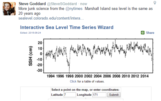
Had they done any research, they would have known that sea level at the Marshall Islands has been falling for several years, and is no higher now than it was 20 years ago.
Interactive Sea Level Time Series Wizard | CU Sea Level Research Group
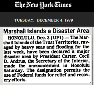
In 1979, the Marshall Islands were underwater.
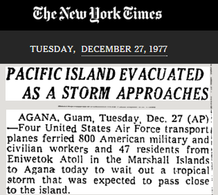
TimesMachine: Marshall Islands a Disaster Area – NYTimes.com
In 1977, the Marshall Islands were evacuated.

The New York Times proved itself to be a traitorous organization with their printing of Walter Duranty’s lies about Holodomor.
Gareth Jones who told the truth about Stalin’s starvation policy that Duranty denies was very conveniently murdered. This had very major ramifications because it influencd Roosevelt’s 1933 decision to grant official recognition to the Soviet Union and the American public’s acceptance.
Last I read the NY Times still refused to give up Duranty’s 1932 Pulitzer Prize and After more than six months of study and deliberation, the Pulitzer Prize Board has decided it will not revoke the foreign reporting prize awarded in 1932 to Walter Duranty of The New York Times. — November 2003
However in 2013 — Last fall, PJ Media and the New Criterion teamed up to award the first-ever Walter Duranty Prize for mendacity in journalism
The Vogue article is breathtakingly bad. Powerline has some good comments on Kerry and Syria that flesh out the Vogue article.
A surprising number of people seem completely unable to differentiate between feeling and thinking. They feel something strongly. They then think of reasons why their feeling must be correct. Often the best reason they can think of is “la la la la la! I can’t hear you!”
Our technological prosperity has made survival so easy that many of these non-thinking yahoos function almost indistinguishably from humans with actual thinking ability. They have jobs, they drive cars, they shop for geegaws. They vote. God help us, they vote.
This is the left-brain vs right-brain issue. I have feelings just like any lefty but I choose logic as my guide when making critical decisions, and leave my feelings out of it, something leftists are incapable of doing. This inability to separate feelings from thinking is a large part of their mental illness.
Hey gator! If you have not seen the series of videos “Gene Wars” it is worth a (somewhat long and extended) watch. https://www.youtube.com/watch?v=W8N3FF_3KvU
For just the quicker version, see Bill Whittle and Stephan Molyneaux discussion concerning it: https://www.youtube.com/watch?v=vY-ueR0OLlQ
Studies indicate that broadly speaking, “conservatives” and “liberals” have measurable differences in brain structure. I would argue that liberals (in the modern usage of that word, not the classical liberal) have under developed or poorly functioning amygdala.
Hey Jason! I wish I had time right now to go into depth on this subject, as it has fascinated me for many years, but I am heading out the door shortly. One of the most interesting case stuides I have seen was a woman who lost the left side of her brain in an accident, and went from a die hard conservative to a far out loony leftist.
I wonder if left handed people are more apt to be scientists/rational types since we use the right side of the brain more.
As usual my curiosity got the better of me.
Seems there is a difference between righties and lefties
http://science.howstuffworks.com/life/inside-the-mind/human-brain/left-handed.htm
True but there is a reason why so many now default to feelings-based decision making. In the absence of higher authority, where is a muddle-headed Progressive to go??
Didn’t anyone notice that the last article was from Guam? No one could possibly know more about human caused flooding than those poor residents of Guam. They live precariously on the razor’s edge, about to tip over at any moment.
https://www.youtube.com/watch?v=iY1mAlFjJTw
Hank Johnson (among others) is undeniable evidence that our system of federal government is untenable. Jeepers creepers….words fail me.
Its not so much the system as the bribery subsidy law signed by Nixon the day after the LP formed.
Most of the Pacific Islands were photographed extensively in World War II, some since. The Marshall Islands are no exception.
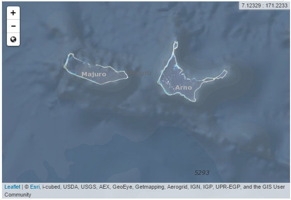
The Island of Delap (AKA Majuro) shown in the map above has gone thru a lot of evolution (above water). The original airfield from WWII was naturally located at the highest, longest, widest ground, at the southeast corner of the island. Today that is where the “town” of Majuro is. The current airport was relocated to the west in 1972.
Here is a photo progression of Majuro, from the old airfield to today the town. It confirms the tide gauge data trend. With no part of the island higher than three meters above sea level, the land Majuro sits on has not changed in 70 years.
1945:
http://www.airfields-freeman.com/HI/Majuro_45Aug.jpg
1976 USGS Photo:
http://www.airfields-freeman.com/HI/Majuro_76Jan11.jpg
Modern, 2014:
http://www.airfields-freeman.com/HI/Majuro_14Sep8_w.jpg
h/t Abandoned and Little Known Airfields for this collection.
This is BTW true and repeatable for literally hundreds of islands across the Pacific.
Thanks. So reality looks a lot like Michael Crichton’s “State of Fear”