Flooding The Islands of Hawaii
Welcome to our website…. This website explores how rising of sea level would affect the land and people of the islands of Hawaii. The website is composed of four sections. The first section, which is where you are now, is the introduction. This section shows some examples of what rising sea level would look like on Oahu through pictures and graphics. The second section illustrates a meter by meter encroachment of water onto the shores of Oahu and Maui. The third section of our web site shows how the graphics depicting the change of sea level were generated including where we got our data and how it was displayed. The fourth and final section of our web site tells a little bit about the Hawaii Mapping Research Group and other forms of research that we undertake.
I wonder if anyone at the university actually bothered to see if sea level is rising before publishing this tripe??


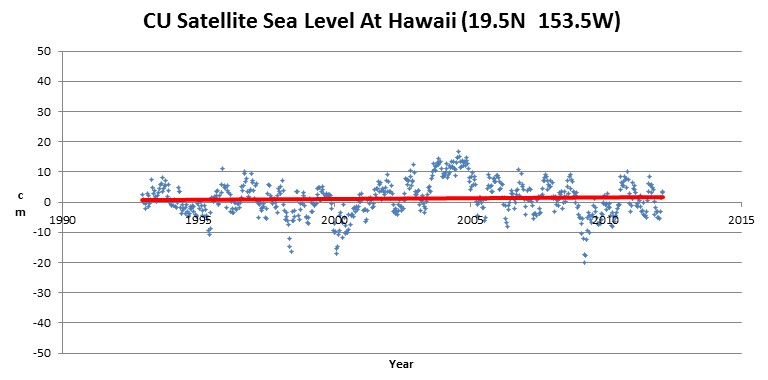
One silly millimeter in 18 years! We are doomed!!
Sorry, misread the chart. One silly cm or so instead.
To me it looks about 1/1/2 mm, but that’s still a proverbial “p**s in the ocean” so to speak.
Sorry the scale on the left is in cm, so 1& 1/2 cm over 22 or more years still completely irrelevant. Just like the aforementioned proverbial.
Steve: What is the link to CU? That looks like a good source for sea level….
sealevel.colorado.edu/content/interactive-sea-level-time-series-wizard
Thanks. I have a different site one from CU, but I like this one better.
NOAA claims (at tides and currents)-
Honolulu- 1.5 mm/yr over the past 100 years, but practically zero since 1990.
Nawiliwili- 1.5 mm/yr since 1955, but practically zero since 1980.
Mokuoloe- 1.3 mm/yr since 1960, but practically zero since 1980.
Hilo- 3.3 mm/yr since 1930, but much lower since 1980.
Kahului- 2.3 mm/yr since 1950, but practically zero since 1990.
Hmmm. Maybe they should do more snorkelling and less blabbing.
“..data from the Maldives and observations in Tuvalu in the Pacific show that islands do have the capacity to grow vertically. This occurs in storm events when waves break and flow over the top
of islands. Under such circumstances, sediment is transported from the reef and beach to the island surface.
“We have documented increases in island elevation of up to 0.3m in parts of the Maldives.
“This vertical building process is also evident in Tuvalu and other low-lying Pacific islands…”
http://www.theaustralian.com.au/news/features/coral-islands-left-high-and-dry/story-e6frg6z6-1225878132101
http://www.sciencedirect.com/science/article/pii/S0921818110001013
More here:
http://www.psmsl.org/data/obtaining/
&
http://www.psmsl.org/products/trends/
That must be some really good sh*t!
Surf’s up dude! 😉
you can send them an email message and point out the FACTS to them: [email protected]
Of course, there is no volcanic activity in Hawaii that could possibly affect things.
Millions of years from now, there will be no Hawaii. It will of sunk below the sea surface regardless of mans efforts. All of it.
South, South, East of the old Hawaii will be the new Hawaii. Volcanically active and forever climbing to the sky. This has always been happening there for millennia as the Volcanic centre moves relative to the crust.
Andy the crust is moving … the hot spot has been relatively stationary for 10’s of millions of years.
Nowhere on the site does it say that the sea level is rising. Sea level rise is just implied as fact. Someone spent a lot of time, effort, and (presumably) money to create a bunch of pretty, and ultimately, meaningless pictures. Perhaps next we’ll see a slick website on the effects of a 300 meter sea level rise on West Virginia.
9000 feet is better ;P
To determine the future of Hawaii, all one needs to do is look at the islands to the northwest, that have moved off the hot spot and are being reclaimed by the ocean.