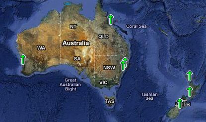
NOAA monitors seven sites in Australia and New Zealand. The average rise rate is 1.63 mm/year, with none of the sites exceeding 3mm/year. At this rate, it will take 613 years to rise one metre and 3067 years to rise Hansen’s five metres.
Average      1.63
---------    ----
Fremantle    1.48
Sydney       0.59
Newcastle    2.19
Townville    1.11
Lyttelton    2.36
Wellington   2.41
Auckland     1.29


Presumably the melting of the southern ice cap is causing isostatic rebound a few thousand miles south of the land masses?
Here I thought t was a regional reaction to the India plate working its way under the Asia plate!
I remember reading something about this on the John Daley site years back that showed only picking location where the levels are rising,
No one noticed the absurd differences, like between Auckland and Wellington, 1.12 mm/year.
More then the rise at Townville and Sydney.
Large tracts of land have risen from or sunk under the sea at Wellington as a result of seismic activity even since the period of European settlement. Auckland sits on a semi-dormant volcanic field and Lyttleton, the port of Christchurch, had a 7.1 earthquake just a couple of months ago and regular big aftershocks since. There is so much seismic activity, now and in the past, that relating sea level to land features must be all but meaningless. NZ is not known as the Shakey Islands for nothing.
If you go to the actual psmsl page: http://www.psmsl.org/data/obtaining/
you can see many more stations which show a different picture. In some places, like
Port Taranaki, the recent trend is down http://www.psmsl.org/data/obtaining/stations/996.php
In most stations the positive trend happened some time ago, with a rather flat tendency in the last 15-20 years.