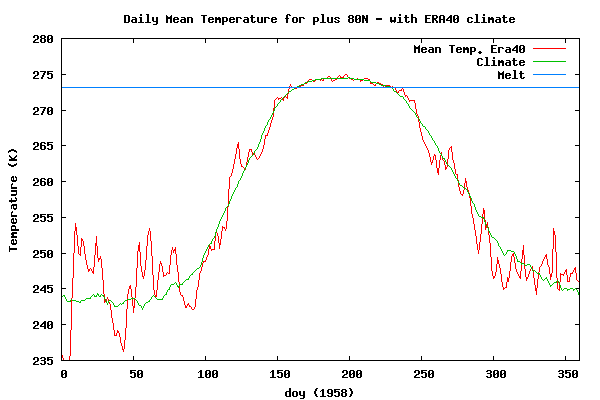
In 1958, temperatures were as much as 10C above normal. The low CO2 levels of the time forced untrapped heat to the pole.
Disrupting the Borg is expensive and time consuming!
Google Search
-
Recent Posts
- Gaslighting 1924
- “Why Do You Resist?”
- Climate Attribution Model
- Fact Checking NASA
- Fact Checking Grok
- Fact Checking The New York Times
- New Visitech Features
- Ice-Free Arctic By 2014
- Debt-Free US Treasury Forecast
- Analyzing Big City Crime (Part 2)
- Analyzing Big City Crime
- UK Migration Caused By Global Warming
- Climate Attribution In Greece
- “Brown: ’50 days to save world'”
- The Catastrophic Influence of Bovine Methane Emissions on Extraterrestrial Climate Patterns
- Posting On X
- Seventeen Years Of Fun
- The Importance Of Good Tools
- Temperature Shifts At Blue Hill, MA
- CO2²
- Time Of Observation Bias
- Climate Scamming For Profit
- Climate Scamming For Profit
- Back To The Future
- “records going back to 1961”
Recent Comments
- conrad ziefle on “Why Do You Resist?”
- conrad ziefle on Gaslighting 1924
- Bob G on Gaslighting 1924
- John Francis on “Why Do You Resist?”
- conrad ziefle on Gaslighting 1924
- Bob G on Gaslighting 1924
- Bob G on Gaslighting 1924
- Bob G on Gaslighting 1924
- conrad ziefle on Gaslighting 1924
- Bob G on Gaslighting 1924


lol….. that lack of CO2 is some powerful $hit!
Steven:
I think you left out the “Important” part of the Arctic Circle Between 66.33N and 51 N!
There must not have been much ice that Winter. Maybe that was the year the Submarines were surfaced at the North Pole! That was probably an event staged by the Sceptics to promote uncertainty regarding climate change! The photo of the submarines was probably taken on a back stage lot in Arizona! 😉
I’ve got a buddy, a retired Navel submariner. He’s got a picture very similar to those pics. I’ll see if I can’t get hold of him one day and produce yet another pic.
It was probably taken in Lake Mead! The Navy used to have a Base out side of Las Vegas to support all the submarines in Lake Mead!
At least I used to ask girls if they wanted to go watch the Submarine Races that were held mainly at night so as not to disturb the tourists! 😉
There really was a Lake Mead Naval Base just north of Nellis air base and it is now part of Nellis. The submarines in Lake Mead are designed to be “Stealthy” and for the 50+ years I lived near there I did not actually see any! But there are rumors! Sort of like Area 51 and Groom Lake!
Your “melt line” is misleading. The ice doesn’t melt only when the air temperature is above freezing because 97 percent of the ice is below water. Ice melts from contact with this water which by definition is at a temperature above freezing. Ice volume decreases when air temperatures are not cold enough to freeze enough water to counter the melt volume. Your melt line shows melting from about day 160 through day 230, whereas the actual melting cycle runs from about day 75 (mid-March) to day 255 (mid-September).
Did you play first base for the Red Sox?
Who is the guy talking about “the melt line”. Am I missing something. You (steven) showed a braph of Arctic temperatures. There isn’t anything having to do with melt lines.
Is this one of the programs that pick out key words and then send an automated canned answer? If such a thing actually exists?
Philip:
The blue line is designated MELT! 😉
Didn’t mean to pin this on Steven, I just see this graph being misinterpreted a lot. Saying Bill Buckner “played” first base for the Red Sox is being charitable. No, I am not him.
Davis …oh that blue line!
B Buckner:
Does that explain the loss of ice during Winter months also? If you watch a time lapse clip of satellite reconstructions for the region you might actually notice ice drifting south past Greenland even during the Winter if the wind is blowing in a favorable direction for ice reduction! Yes Due to normal ocean currents warmer water enters the Arctic region from the Equatorial region. Sometimes faster and sometimes slower, just natural variations that all global weather patterns experience!
The overall end result is that Arctic ice content is just a way to waste taxpayer money as the extent is not proof of anything more than changing weather patterns.
Yes, warm water melts the ice……when the wind and currents take it far enough south.
lol, That’s not Steven’s line.
http://ocean.dmi.dk/arctic/meant80n.uk.php
Take the line up with the Danish Meteorological Institute. They probably put that there just to trick everybody. Or maybe it could be to just supply a reference point.
And tell Steve, it wasn’t just the Sox, didn’t you spend several years of futility with the Cubs?
Way OT, but I think its funny…..
From Curry’s blog,
Martha | March 3, 2011 at 8:23 am | Reply
Curry: “This is consistent with sea ice simulations I did in the 1990?s with a stand alone sea ice model. It is pretty difficult to get the wintertime sea ice not to return, would need much more warming than say tripling CO2.”
No it is not consistent with what you did back in the 90’s; and your statement is not consistent with the researcher’s.”
Martha is telling Curry what Curry’s work was and wasn’t consistent with.
http://judithcurry.com/2011/03/02/the-harry-potter-theory-of-climate/#comment-51708
So much for epistemic levels.
LOL
1958 was another cold, snowy winter along the east coast, unusually cold in Florida. There was a 3 inches snowfall in Tallahassee. their all time record.
It was a prime example of warmcold ahead of its time!