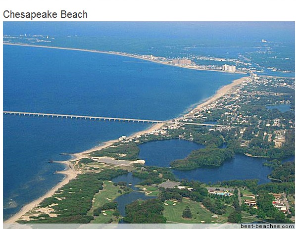
For most of the 20th century, Chesapeake Beach, Maryland, was known for its boardwalk, amusement park, and wide, sandy beaches, popular with daytrippers from Washington, D.C. “The bathing beach has a frontage of three miles,” boasted a tourist brochure from about 1900, “and is equal, if not superior, to any beach on the Atlantic Coast.”
Today, on a cloudless spring afternoon, the resort town’s sweeping view of Chesapeake Bay is no less stunning. But there’s no longer any beach in Chesapeake Beach. Where there once was sand, water now laps against a seven-foot-high wall of boulders protecting a strip of pricey homes marked with “No Trespassing” signs.
Surveying the armored shoreline, Jim Titus explains how the natural sinking of the shoreline and slow but steady sea-level rise, mostly due to climate change, have driven the bay’s water more than a foot higher over the past century. Reinforcing the eroding shore with a sea wall held the water back, but it also choked off the natural supply of sand that had replenished the beach. What sand remained gradually sank beneath the rising water.
EPA scientist warns Atlantic seaboard will be swallowed by rising seas | Grist
Complete BS. There was never any beach by the boardwalk, and the other beaches are still there. See old and recent pictures below.
mywildrace – ChesaPeake Beach, MD
h/t to Robertvdl


List of dams and reservoirs of the Susquehanna River
The Susquehanna River, in the Mid-Atlantic States of the USA, has a collection of dams. These dams are used for power generation, flood control, navigation and recreation. These dams have local and regional environmental impacts on the river and the CHESAPEAKE BAY, both positive and negative.
The dams have a positive impact on the environment. They slow water, trapping silt and pollutants. Conowingo Dam is credited with preventing much of the silt from Pennsylvania from reaching the Chesapeake Bay.
https://en.wikipedia.org/wiki/List_of_dams_and_reservoirs_of_the_Susquehanna_River
https://en.wikipedia.org/wiki/Susquehanna_River#Bridges.2C_ferries.2C_canals_and_dams
https://en.wikipedia.org/wiki/File:Susq.png
NO silt NO beach one plus one equals
The river drains 27,500 square miles (71,000 km2), including nearly half of the land area of Pennsylvania. The drainage basin (watershed) includes portions of the Allegheny Plateau region of the Appalachian Mountains, cutting through water gaps in the lateral mountain ridges in a broad zigzag course to flow across the rural heartland of southeastern Pennsylvania and northeastern Maryland. The river empties into the northern end of Chesapeake Bay,
What do people think most beaches are? They are mountains broken to pieces.In this case part of the Appalachian Mountains.
The Appalachians first formed roughly 480 million years ago during the Ordovician Period, and once reached elevations similar to those of the Alps and the Rocky Mountains before they were ERODED
https://en.wikipedia.org/wiki/Appalachian_Mountains
However, not all sand is from rivers, much is from wave action on shore rocks. Analyses of sand shows the sands in the South are pulverized rock from the North—New England Coast and North. It’s called “longshore drift” or transport. That’s why people noticed patches of colored sand moving across their beaches and decided to put up jetties to stop from losing their sand. Of course, this caused sand to accumulate on the north side of a jetty and to erode away from the south side. The result was the building of jetties all the way down the Eastern Seaboard. More recently, as people realized the idiocy of this idea, many jetties have been removed and sand allowed to move naturally. They were, in effect, robbing Florida of its sand by putting jetties up in New Jersey.
Higley:
The sand originates in the mountains as they erode and a good portion of Florida is probably from Canada and the Appalachians. Erosion of the beaches is part of the natural process, but the sand must be allowed to be replenished from the mountains. Building to close to the shore has removed necessary vegetation that helped control erosion.
More man made beach problems.
Nile Delta
The outer edges of the delta are eroding, and some coastal lagoons have seen increasing salinity levels as their connection to the Mediterranean Sea increases. Since the delta no longer receives an annual supply of nutrients and sediments from upstream due to the construction of the Aswan High Dam,
https://en.wikipedia.org/wiki/Nile_Delta
Po Valley
Since the Messinian (7-5 mya) the system has been filling with sediment mainly from the older Apennines but also from the Alps. The shoreline of the Adriatic depends on a balance between the sedimentation rate and isostatic factors. Until about 1950 the Po delta was prograding into the Adriatic. After that time due to human alteration of geologic factors, such as the sedimentation rate, the delta has been degrading and the coastline subsiding, resulting in ongoing contemporaneous crises in the city of Venice.
etc etc
I have a townhouse right on the bay in Chesapeake Beach with a wide, white sandy beach 20 yards from my back door which is same as it was 15 years ago. Also, I’m sorry but that is NOT a photo of Chesapeake Beach.
you’re right
https://en.wikipedia.org/wiki/File:AerialviewoftheentrancetotheChesapeakeBayBridgeTunnel.jpg
https://en.wikipedia.org/wiki/Chesapeake_Bay_Bridge-Tunnel
If you’re lucky you can see these pass by
http://1.bp.blogspot.com/-n7D3_9q40lA/T0C4OHd7c3I/AAAAAAAADyI/kS9mp3NxJWM/s1600/uss_theodore_roosevelt_(cvn_71),_aircraft_carrier.jpg
I was there two months ago and I was not impressed.