Four years ago, BOM’s leading expert declared that Australia was in a permanent drought.
Richard Macey
January 4, 2008IT MAY be time to stop describing south-eastern Australia as gripped by drought and instead accept the extreme dry as permanent, one of the nation’s most senior weather experts warned yesterday.
“Perhaps we should call it our new climate,” said the Bureau of Meteorology’s head of climate analysis, David Jones.
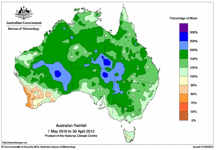
Since his ingenious remarks, Australia has had its wettest two year period on record.


damn! I moved from what was a hot dry area…to a wetter cooler place,
the old place is topping the rain records
and all I got was cooler not wetter.
bad move:-)
This is why Gillard needs to shut down the internet sites that provide facts. It is imperative to keep the proles frightened and the truth hidden. 🙂
The above rainfall map 1 May 2010 to 30 April 2011 includes six months of a ‘Dry’ Cycle (alleviated by explosive volcanic ‘albedo’ in Indonesia ) and six months of a ‘Wet’ /Normal period exacerbated by ‘albedo’ from volcanic activity in Mexico and Chile. (disruptive volcanic dust cloud over Southern Australia associated with flooding in NSW and Victoria.)
We have since seen the onset of a One Solar/Earth Year ‘Dry’ Cycle over Australia (early January 2012) accompanied by the break up of monsoon cloud (no categorised cyclones over the Australian Mainland from December 2011 to the present.) The recent rain events experienced on the Eastern coastal fringe were the result of rain bands formed from the broken up monsoon cloud (originating over a vocanically active Indonesia) forced Southward by the onset of this ‘Dry’ Cycle.
The ‘almost’ cyclone over Fiji was also the result of one of these ‘rain bands.’ These cloud movements are easily followed on the daily satellite cloud maps.
There was also a rain event originating in the Indian Ocean that precipitated over Eastern Australia in April, emphasising the unique nature of Australia as one of the last countries to be affected by the ‘orbit’ of these ‘Dry’ Cycles. The Indian Ocean and related longitudes are now in a Two Solar/Earth Year ‘Wet’/Normal Period. (Note, the prevailing weather/cloud travels West to East, the ‘Dry’ Cycle encroaches East to West (30 degrees longitude/month, with the Earth’s Magnetic Field.) We are now experiencing the full effects of the current One Solar/ Earth Year ‘Dry’ Cycle over Australia. This ‘Dry’ Cycle has ended over Europe and is soon to be ended over America, to be replaced (in turn) by a Two Solar/ Earth Year ‘Wet’/Normal Period, (Australia 2013 – 14) and then a severe Five Solar/Earth Year ‘Dry’ Cycle, (Australia 2015 – 19.) These ‘Dry’ Cycles were identified and exactly predicted by Alex S Gaddes in his book ‘Tomorrow’s Weather (1990.) An updated version of this work (including ‘Dry’ Cycle forecasts to 2055) is available as a free pdf from [email protected]
Nothing to do with El Nino/La Nina.
Nothing to do with CO2/AGW/hockey.
Maybe Davie Jones should put his new climate back in his locker
Didn’t they say dry areas would get drier and wet areas would get wetter? B.S.