Did Global Warming Set Stage For Duluth Flooding?
Climate Central | June 22, 2012 12:51 p.m.
Here are some of the facts regarding the unprecedented and devastating flooding event that took place this week in Duluth. A cold front sparked slow-moving thunderstorms that repeatedly moved over the Duluth area between June 17-19, dumping between 8 and 10 inches of rain in a 24-to 36-hour period on Duluth and neighboring communities in Minnesota and Wisconsin. An all-time record 24-hour rainfall was set in Duluth, with 7.24 inches of rain falling during that period. The rainfall came during an already wet month in Minnesota, as the state rapidly lurched from drought conditions during the spring to suddenly having a precipitation surplus.
Did Global Warming Set Stage For Duluth Flooding? · OPB News
Temperatures were normal or below on the 19th and 20th – the days when the rain fell. The rain was triggered by cold air, not global warming.
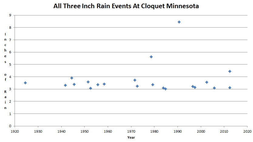
The graph below shows all three inch rain events at Duluth, including the two last week. There was an 8.3 inch rainfall in one day in 1990, more than the sum of the two days last week.
In 1978 there was a 5.6 inch rainfall, more than either day last week. 1978 was one of the coldest years in Minnesota history. As usual, Heidi is just spreading propaganda.
U.S. Historical Climatology Network


The forecast Two Solar/Earth Year ‘Wet’/ Normal Period (Alex S. Gaddes ‘Tomorrow’s Weather’,1990) has reached Duluth. (thirty degrees of longitude/month with the Westward Solar orbit of the Earth’s Magnetic Field.) I invite interested parties to follow its progress across America and the Pacific, reaching Australia early January 2013. Those seeking scientific ‘proofs’ can be obtained in an updated version of the above work (with ‘Dry’ Cycle forecasts to 2055) available as a free pdf from [email protected]
I live here. This was a classic clash of air mass we usually see in cooler months with lake enhanced precipitation. On this map: http://weather.unisys.com/archive/sfc_map/1206/12062000.gif
You will notice Minneapolis at 91F with 68F dewpoint. Duluth, just above the warm front, has a temp of 61F and dewpoint of 57F. Grand Marais is NE of Duluth on the shore of the lake with a temp of 55F and dewpoint of 54F. Winds were E to NE off the Lake bringing in cooler but humid air clashing with the hot humid air coming in from the south. Lots of humidity with a big temp difference, and good lift. The ridges on the Lake shore enhance the lift with the east winds, and BAM! Lots of precip. Classic! A couple trained spotters reports came in with 10″ readings. One in Duluth and one in Two Harbors just up the shore, but mostly 5-8″ readings in the area. This was just an awesome weather event with a slow moving front perfectly positioned to do what it did.
Since when does CO2 dictate the speed and position of pressure systems?
Duluth? Clearly the floods were God’s vengeance for their evil racism…… http://suyts.wordpress.com/2012/06/22/have-you-seen-anything-more-obscenely-stupid/