Guest post by Joe Bastardi.
Joe lets us know what to expect over the next nine months.
————————————————————————————–
The coming nino is in line with the cold pdo el ninos we saw in the 1950s-1970s and most recently in 2009-2010. This has been well telegraphed and a mainstay of the Weatherbell.com forecast since winter. In fact the pattern is not dissimilar to the la nina/el nino couplet of 1975-1976 where a very warm winter was followed by a very cold winter. The key is that the el nino coming, because of the overall now cold decadal state of the Pacific, will be centered in the central Pacific while the eastern Pacific is not as cool.
As a side note, the forecast of the development of the nino was part of the reason Weatherbell has the lowest Ace Index forecast of the major players. I believe that that lass than 1/3 the total ace of 70-90 this year occurs south of 25 north, where we have seen the strongest of the storms in the big ace season the past 10 years. However the forecast, made back in March , is already showing merit with the idea that the problem this year will be in close development with over 50% of the ace within 200 miles of the US coast. There seems to be linkage to very cold 400 mb temps in March with el ninos coming on, as the 10 lowest ace years have temps below normal from Africa to the Caribbean at that level in March and in 7 of them, an el nino developed! Well it did this year too. By the way, the way I started looking at that was because I was debunking the IPCC trapping idea and came up with this linkage in my studies. So this will be an interesting test. I presented this idea, along with a tornado linkage to temps at that level, at the ICCC7 conference, so its not like I am saying this after the fact.
The reason for this is that the el ninos of the cold PDO are basically a response to the longer lived colder signals of the la ninas. Joe D Aleo ‘s research shows that cold pdo el ninos last on average 9 months, while the la ninas average 21. It was why I was adamant last year that the la nina WAS NOT DONE and that the el nino would come on this year. In fact , in statements made at the end of the winter 10-11, I said I was uncertain about the temps of the winter 11-12, but felt that the winter of 12-13 would be very cold for the US.
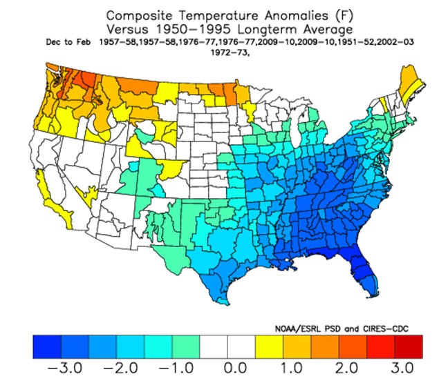
The key again is the fact that the nino is simply a reaction to the cooling that is occurring. This means that once the reaction is complete, it will fade, and part of the reason for that is that the Pacific is in its cooler mode, so the cool will quickly try to attack the warmth. The closest analogs to the upcoming winter are 57-58,76-77,09-10, with secondary winters of 51-52, 72-73 and 02-03. 02-03 was included because a long standing 3 year la nina occurred before it. The fact is of the last 6 years, we have had 4 years with la nina and now this will make 2 with the el nino. This is in line with the jagged temp fall that has started since the pdo flipped
A look at ALL el nino winters since 1951 shows this:
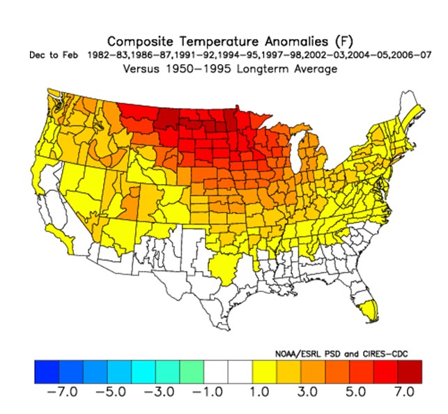
Now look at the ninos when the PDO is warm in its decadol sense, the 1980s into the 1990s
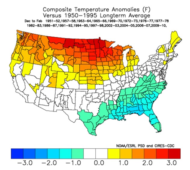
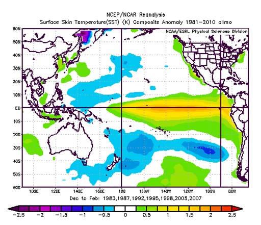
Here is the blend of the cold PDO nino winters
now my winters, double weighted for the prime analogs, with the secondary ones, from this point given a single weight
What is needed for the very cold winter is a sudden spike of the PDO during the winter while the nino is occurring. Both the warmer cases, 51-52 and 72-73, were not as cold in the PDO. But you can easily see the major differences in the warm and cold versions. The warm versions have the water warmer in a larger area from the cent pac all the way back to the coast
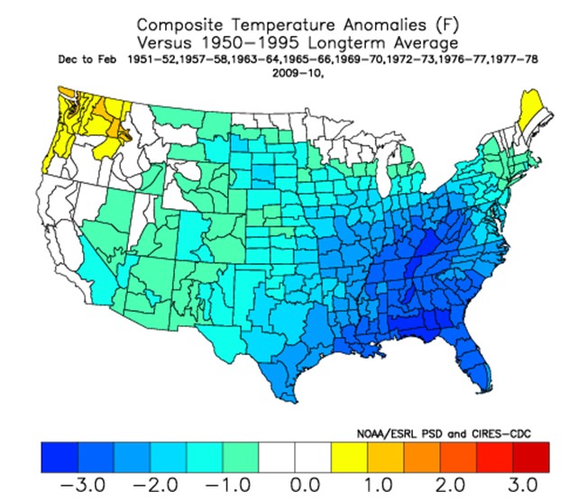
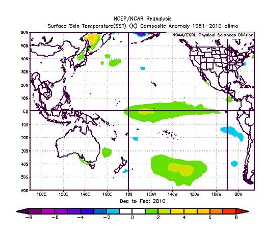
The cold winters, have the water warm in the central Pacific the most recent example 2009-2010
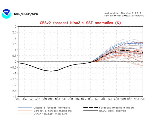
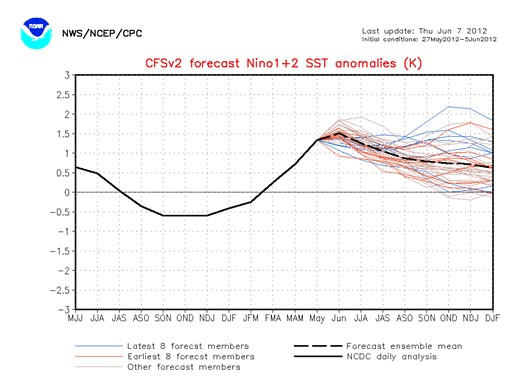
A look at the CFSV2 shows the water warming into the core of winter in nino3.4
while we fade in nino1.2 ( east)
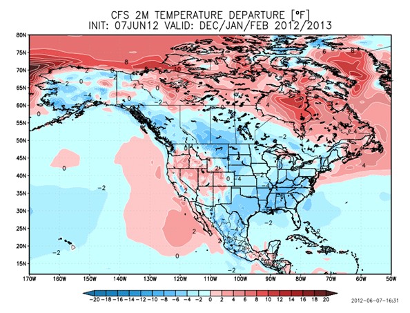
one can see the CFS looking very much like the analog package I picked out back in March for the upcoming winter
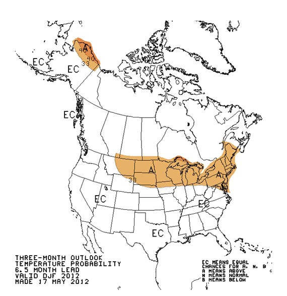
which is quite a bit different from NOAA which seems to be just taking the warm pdo ninos, though I can t speak for them since I was not a part of the forecast. It does look like the international research institute forecast which makes me wonder, why is it a noaa function when it simply comes from the IRI, or looks too
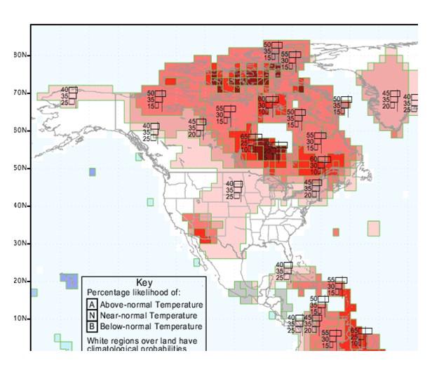
For instance look at the IRI for Sep-Nov
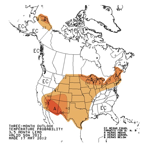
Here is Noaa for the same time
You can look at all of them and see how close they are, which makes me wonder, is taxpayer money being spent when its simply the same thing as the IRI?
You can go line all the rest up over the next 4 forecast periods, you will see they are by and large, the same forecast. The IRI does not go past 4 months, so here is the NOAA winter, which looks like the warm pdo version
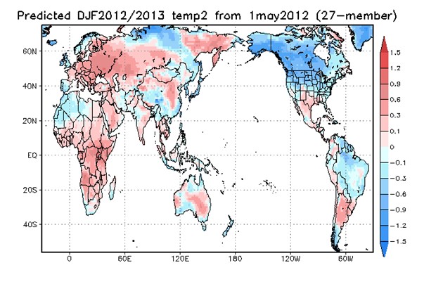
and the JAMSTEC and obviously myself are not in agreement
But this was predictable and for those following us on weatherbell, we have said this is a slam dunk nino coming on. The JAMSTEC has had it for over 6 months , btw. So now we have an el nino watch. Watch all you want, its coming because of the cyclical reality of the climate pattern. Its that simple, even though a lot of people that make a lot of money at researching this will scream at me for that comment


Good content, bad grammar.
Sentence fragments from the grammar critic.
I’m just saying, the post would look more professional if it were cleaned up.
Content is really all that matters John B.
Thanks Joe for pointing out how simple it really is when you take out the “CO2 forcing”.
The winter of 1976-1977 was memorable, being the only year in my lifetime it snowed here in central Florida:
http://news.google.com/newspapers?nid=rwEhk56xNqMC&dat=19770119&printsec=frontpage&hl=en
Joe, I watched your presentation at Heartland. Loved it. excellent. It was one of my favorites. You are obviously a very smart guy. I’ll side with John and suggest a cozy relationship with spell check. 🙂 This will ensure you properly represent your extensive expertise. Very interesting, this report. I like the fact that those of us in the NW are less likely to get the deep freeze. We love El Nino up here.
Well I’ve been following Hansen’s weather predictions since about 2008 and it’s become obvious to me that he doesn’t have a clue. Sometimes he forecasts the exact opposite of what happens.
Now look at Joe’s forecast which was not bad at all from a year ago:
http://wattsupwiththat.com/2011/07/22/bastardi-just-say-no-to-el-nino-at-least-till-2012/
Regardless of the grammar, it is so very refreshing to have a post that is not so obviously skewed to promote a doctrine, one from which I can learn much (and check to see how things play out in the coming months). I will be spending some time comparing the weather patterns. Thank you.
You are on the wrong track Joe.
ENSO/La Nina is a failed forty year Fantasy, exported from places like the University of East Anglia in the early 1970s, and unfortunately taking root in Australia, Canada etc. It has no predictive qualities whatsoever when applied to long range weather forecasting or Climate Change. (Note the dismissal of the influence of ENSO by Steffen and the ‘Hockey Stick’ Push in the ‘Critical Decade’ Report – thus sparking the ongoing dispute/competition with the ENSO/La Nina obsessed BoM.)
Both Ideologies are insupportable by current events, logic, or historical records.
America has just entered a Two Solar/Earth Year ‘Wet’/Normal Period, after a One Solar/Earth Year ‘Dry’ Cycle. This One Solar/Earth year ‘Dry’ Cycle reached Australia January 1st, 2012. The Two Solar/Earth Year ‘Wet’/Normal Period started over the longitudes of China more than a year ago, and will affect Australia 2013 -14. This Two Year ‘Wet’/Normal Period will precede a severe Five Solar/Earth Year ‘Dry’ Cycle, that will reach Australia 2015 -19. These Solar induced ‘Dry’ Cycles and the intervening ‘Wet’/Normal Periods orbit the planet with the Earth’s Magnetic Field (thirty degrees of longitude/month.) Australia is one of the last countries to be affected in the orbit of these Cycles.
Alex S. Gaddes identified and worked out an exact method of forecasting these ‘Dry’ Cycles, based on Astronomical/Gravitational/Geometrical Ratios in his book ‘Tomorrow’s Weather’ (1990.) An updated version of this work (with ‘Dry’ Cycle forecasts to 2055,) is available as a free pdf from [email protected]
You remind me of Johannes Kepler’s Harmonices Mundi. 😉
we will see what we will see
I slapped this together very fast for Real Science as the dreaded El Nino watch was issued yesterday. Sort of like a heavy snow watch, after 5 inches has fallen
So, for Joe Bastardi (whom I have followed for years), will this be a Modoki setup on El Nino?
Still hanging out at Underground Weather? I quit going there a couple years ago…
No…I told them to stick it.
lol. So Hansen is finally going to be right?
A broken clock is right twice a day.
lol. When you say there will be an el nino over the next 5 years you stand a good chance of being.
This guys voice, attitude and body language bothers me. All is not well with him. No doubt.
Great article, well supported with facts. Joe you have never pretended to be an English major, your stats and analysis far trumps the grammar. Thanks for this!
I hope you are wrong about the 76-77 analog…that was the driest winter on record here in the Eastern Sierra.