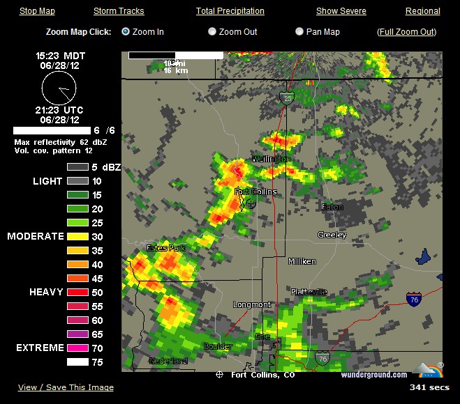
Current Cheyenne NEXRAD Radar Map | Weather Underground
* Flash Flood Warning for…
central Larimer County in north central Colorado
* until 445 PM MDT
* at 315 PM MDT… National Weather Service Doppler radar indicated
very heavy rain from a thunderstorm within the High Park wild fire
area approximately 2 miles southeast of BUckhorn Mountain… or 11
miles west of Fort Collins. This storm was nearly stationary.
* Locations in the warning include but are not limited to BUckhorn
Mountain.
Precautionary/preparedness actions…
National Weather Service radar has indicated that 0.40 to 0.50 inch
of rain has fallen on the southeast side of the High Park burn scar
in the past 30 minutes.
A Flash Flood Warning means that flooding is imminent or occurring.
If you are in the warning area move to higher ground immediately.
Residents living along streams and creeks should take immediate
precautions to protect life and property. Do not attempt to cross
swiftly flowing waters or waters of unknown depth by foot or by
automobile. Turn around… do not drown.
Excessive runoff from this storm will cause flash flooding of creeks
and streams… roads and roadside culverts. The heavy rains could also
trigger rock slides or debris flows in steep terrain.


It was 108 today in Illinois and Indiana. That sounds incredibly hot, until you learn it was 118 in Illinois during 1954 and 116 in Indiana during 1936.
The fires made the TV news here down under. “Epic” was used to describe them.
I guess everyone in Colorado has evacuated to Florida.
Nothing epic about the fires. A few hundred houses burned, because people built them in places which were a disaster waiting to happen.
Very True.
Read my article
http://www.gather.com/viewArticle.action?articleId=281474981434965
No fires UK No summer
http://news.sky.com/story/953954/travel-havoc-ahead-amid-heavy-flooding