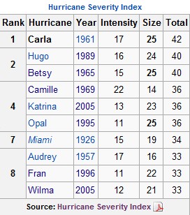
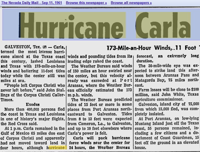
The 1960s brought three of the most intense hurricanes in US history, led by Carla – which made landfall with 173 MPH winds. Joe Romm wasn’t around at the time to blame it on Barry Goldwater.
Disrupting the Borg is expensive and time consuming!
Google Search
-
Recent Posts
- Gaslighting 1924
- “Why Do You Resist?”
- Climate Attribution Model
- Fact Checking NASA
- Fact Checking Grok
- Fact Checking The New York Times
- New Visitech Features
- Ice-Free Arctic By 2014
- Debt-Free US Treasury Forecast
- Analyzing Big City Crime (Part 2)
- Analyzing Big City Crime
- UK Migration Caused By Global Warming
- Climate Attribution In Greece
- “Brown: ’50 days to save world'”
- The Catastrophic Influence of Bovine Methane Emissions on Extraterrestrial Climate Patterns
- Posting On X
- Seventeen Years Of Fun
- The Importance Of Good Tools
- Temperature Shifts At Blue Hill, MA
- CO2²
- Time Of Observation Bias
- Climate Scamming For Profit
- Climate Scamming For Profit
- Back To The Future
- “records going back to 1961”
Recent Comments
- Bob G on Gaslighting 1924
- Bob G on Gaslighting 1924
- conrad ziefle on Gaslighting 1924
- Bob G on Gaslighting 1924
- Bob G on Gaslighting 1924
- arn on Gaslighting 1924
- conrad ziefle on Gaslighting 1924
- Gordon Vigurs on Gaslighting 1924
- conrad ziefle on Gaslighting 1924
- Robertvd on Gaslighting 1924


You’re not exactly correct. It wasn’t the most powerful hurricane in history. That honor goes to Hurricane Wilma in 2005. It was the most intense land falling hurricane because of its size.
http://en.wikipedia.org/wiki/Hurricane_Carla
What Carla was was the worst hurricane according to the Hurricane Severity index. It takes into account size and strength. Camille was stronger but smaller, for example, so it ranks lower.
It struck TX as a category 4 hurricane. It was weakening at the time from its peak intensity.
Wilma was stronger, but smaller. Carla was also one of the largest hurricanes on record.
Largest hurricane doesn’t mean strongest hurricane and doesn’t always mean most intense. Gusts also were as high as 170mph, but it did not make landfall with 170mph sustained winds.
I have far too many hurricanes under my belt that I’ve lived through. Carla wasn’t one, but I didn’t have to do much research to see that you didn’t do a whole heck of a lot before posting this.
Correction, “it was the strongest on the hurricane severity index due to its size”
One might equate “size and strength” with power ;^)
Hehe, size is like current (amperage), strength is like voltage. Yeah, I like that.
You could multiply the two, and then multiply by (or, better, integrate over) duration, and multiply by a conversion factor, and rate hurricanes by energy in kW-hours or joules. 🙂
“Joe Romm wasn’t around at the time to blame it on Barry Goldwater.”
Perhaps not, but even if someone had tried to blame the hurricane on convervative policies or rampant industrialism, they would surely have just been ignored and assumed to be off their rocker! I doubt anyone, scientist or otherwise, would have paid them a moment’s notice. That says a lot, I think.
RTF
* conservative
Wind gusts to 173 are still pretty impressive compared to Irene’s awesome 48 mph winds.
http://www.wunderground.com/blog/JeffMasters/comment.html?entrynum=1906
“The eye of Hurricane Irene is back over water, after the hurricane completed a 11-hour crossing of eastern North Carolina. Irene came ashore over Cape Lookout, North Carolina at 7:30 am EDT this morning as a Category 1 hurricane with 85 mph winds. The Cedar Island Ferry Terminal measured sustained winds of 90 mph, gusting to 115 mph at 7:19am, as measured by a Department of Transportation official. I suspect this measurement came when a thunderstorm near Irene’s center collapsed, sending a powerful downburst to the surface. A trained spotter on Atlantic Beach, NC measured sustained winds of 85 mph, gusting to 101 mph at 10:35 am. The Hurricane Hunters measured 80 mph winds over water at the time of landfall. However, no regular weather station or buoy has measured sustained hurricane force winds in Irene, with the highest winds being 67 mph at the Cape Lookout, North Carolina buoy as Irene made landfall. Winds have peaked along the coast of Virginia, where sustained winds of 61 mph were observed at 6 pm EDT at Chesapeake Bay Light. Irene’s passage over land weakened the storm slightly, and satellite loops show more dry air has wrapped into the storm. The radar presentation of Irene visible on the Norfolk, VA radar is still very impressive–Irene is dropping torrential rains over a huge area–but there is much less rain over the storm’s southeastern quadrant, over water. Radar-estimated rainfall shows a 50 mile-wide band of 8+ inches of rain has fallen from where Irene made landfall at Cape Lookout, North Carolina, northwards to Dover, Delaware. Some isolated amounts of 15+ inches may have fallen, according to the radar estimates. Bunyan, NC has received 14.00″ so far, and the towns of Washington, New Bern, Grifton, Newport-Croatan, Wonona, NC, all received more than ten inches. Norfolk, Virginia had received 7.73″ as of 7pm EDT, and Suffolk, Virginia, 8.00”
SMFR data also showed the hurricane force winds were mostly off shore.
Something you may not realize is that ground weather stations in hurricanes rarely capture the highest winds because they lose power, or they’re too far apart, or the highest winds are too narrow that they aren’t recorded.
http://www.nhc.noaa.gov/data/tcr/AL092011_Irene.pdf
It was technically a hurricane at landfall but the strongest winds were well east of the center. The hurricane hunters don’t lie. The dropsonde and SMFR data is pretty much as-is when they release it.
What are you getting at? Are you trying to say that Camille’s 190 MPH winds weren’t extreme?