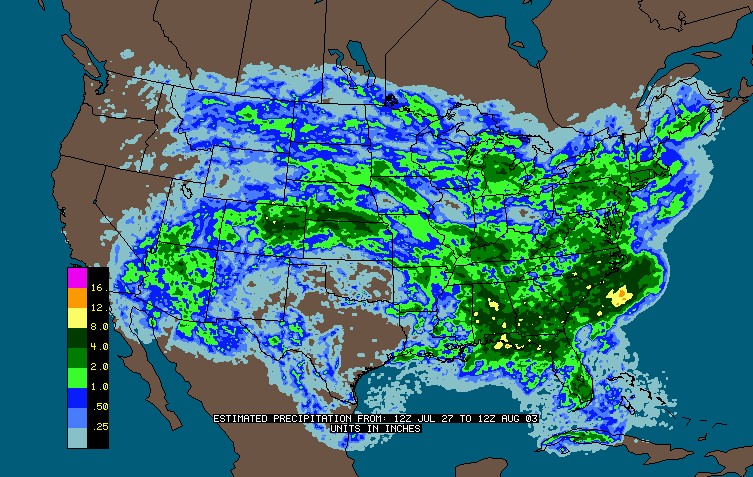
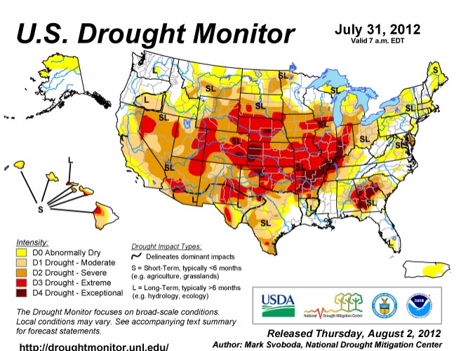
Much of the state got 25-35% of the normal annual rainfall this week, and is listed by the the (always honest) US Government as being under extreme drought.
Disrupting the Borg is expensive and time consuming!
Google Search
-
Recent Posts
- Analyzing The Western Water Crisis
- Gaslighting 1924
- “Why Do You Resist?”
- Climate Attribution Model
- Fact Checking NASA
- Fact Checking Grok
- Fact Checking The New York Times
- New Visitech Features
- Ice-Free Arctic By 2014
- Debt-Free US Treasury Forecast
- Analyzing Big City Crime (Part 2)
- Analyzing Big City Crime
- UK Migration Caused By Global Warming
- Climate Attribution In Greece
- “Brown: ’50 days to save world'”
- The Catastrophic Influence of Bovine Methane Emissions on Extraterrestrial Climate Patterns
- Posting On X
- Seventeen Years Of Fun
- The Importance Of Good Tools
- Temperature Shifts At Blue Hill, MA
- CO2²
- Time Of Observation Bias
- Climate Scamming For Profit
- Climate Scamming For Profit
- Back To The Future
Recent Comments
- Bob G on Analyzing The Western Water Crisis
- arn on Analyzing The Western Water Crisis
- Bob G on Analyzing The Western Water Crisis
- Bob G on Analyzing The Western Water Crisis
- Bob G on Analyzing The Western Water Crisis
- Hank Phillips on Analyzing The Western Water Crisis
- Hank Phillips on Analyzing The Western Water Crisis
- Hank Phillips on Analyzing The Western Water Crisis
- Hank Phillips on Analyzing The Western Water Crisis
- Bob G on Analyzing The Western Water Crisis


Most of the state got 1 to 2″ of rain. Only a small part got above 4″, and the only spot that got 8″ was at the highest elevations above 14,000 ft – which you would expect.
It takes more than a quick week of rain to reverse an extreme drought. Remember that earlier this year, the FL panhandle had pretty decent drought, and it took about 20″ of rain for it to reverse.
The heaviest rain is in the urban corridor around Denver and on the eastern plains which are listed as extreme drought. If you lived in Colorado (as I do) then you would know that the heaviest thunderstorms occur on the plains. Nice try though.
You can’t read a map then. That yellow dot is not Denver.
Besides even if they got 8″ of rain in one day, or would week, you need long term persistent relief to reverse a bad drought.
The heaviest precipitation occurs at the highest elevations. Period. It’s called orographic precipitation.
http://stevengoddard.wordpress.com/2012/08/04/we-have-a-booby-prize-winner/
To prove it for you:
http://www.wrcc.dri.edu/pcpn/co.gif
Here is the last 60 days…
http://naturalclimate.files.wordpress.com/2012/08/screenhunter_05-aug-02-12-472.jpg
Looks kind of wet there if you ask me. Classic droughtflood?
It’s funny that they have us in such a dark red down here when it sure doesn’t look like an extreme drought here.