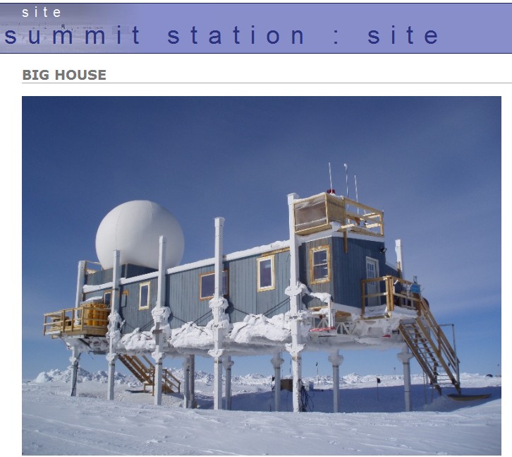
The Greenland Summit camp is on stilts, so that they can jack it up to keep it from getting buried by the metre of meltdown which accumulates every year.
Disrupting the Borg is expensive and time consuming!
Google Search
-
Recent Posts
- Gaslighting 1924
- “Why Do You Resist?”
- Climate Attribution Model
- Fact Checking NASA
- Fact Checking Grok
- Fact Checking The New York Times
- New Visitech Features
- Ice-Free Arctic By 2014
- Debt-Free US Treasury Forecast
- Analyzing Big City Crime (Part 2)
- Analyzing Big City Crime
- UK Migration Caused By Global Warming
- Climate Attribution In Greece
- “Brown: ’50 days to save world'”
- The Catastrophic Influence of Bovine Methane Emissions on Extraterrestrial Climate Patterns
- Posting On X
- Seventeen Years Of Fun
- The Importance Of Good Tools
- Temperature Shifts At Blue Hill, MA
- CO2²
- Time Of Observation Bias
- Climate Scamming For Profit
- Climate Scamming For Profit
- Back To The Future
- “records going back to 1961”
Recent Comments
- Bob G on Gaslighting 1924
- Bob G on Gaslighting 1924
- conrad ziefle on Gaslighting 1924
- Bob G on Gaslighting 1924
- Bob G on Gaslighting 1924
- arn on Gaslighting 1924
- conrad ziefle on Gaslighting 1924
- Gordon Vigurs on Gaslighting 1924
- conrad ziefle on Gaslighting 1924
- Robertvd on Gaslighting 1924


Where are the wind turbines that supply power for this operation? It must be a drag to get up on the roof and clean snow off the solar panels all the time.
I don’t see an awful lot of evidence that much emphasis has been placed on Clean Energy and Recycling. Shame to have to ruin the environment like that just to prove that it snows in Greenland all the time.
There actually is a wind turbine there, but their site seems to be down now so I can’t get the picture.
Seriously? I expect they get most of their electrical power by diesel generation.
Lubricant in the turbines has to be heat traced in the cold. I wonder what the ratio of power input to power output of a turbine is.
http://www.summitcamp.org/site/
The place would make a very good denialist re-education camp. I think.
Latest Reported Power Generation
Type Power Total Energy At
Generators Total (10) 41.060 kW 1613.41 mWh 2012-08-07 00:15 WGST
Wind (22) 0.005 kW 23813 kWh 2012-05-30 14:15 WGST
http://www.summitcamp.org/status/power/
There are two reasons for the stilts:
As you said, to keep the accumulated snow from burying the building,
But also to keep the heated building from melting the snow and ice and sinking. All the buildings at Thule Airbase are built that way to keep them from sinking into the permafrost. This is common practice in the Arctic.
It is now but all the buildings on Thule Air base are not built that way. Mess Hall isn’t, Hangars aren’t, If I remember the BX isn’t, not sure about the TOW club.
In fact if you really want to get down to it, none of the buildings in Thule are built like the one above, although allot of them are built on steel frames, some what elevated above ground, and allot are skirted to the ground, but not like the one above.
The stilts are there to protect the station from a dangerous increase in sea level, brought on by the current massive meltdown. You cannot see the lifeboat, as it is lashed to the far side, next to the water slide.
So that’s what the fishing rods and harpoon on the roof is for, OK.
At least they may survive flooding if Ernesto or Florence should hit Greenland.
I wonder if the 6 storey tall DYE-2 station been completely subsumed in wintertime yet?
Dye-2, central Greenland, just erected:
http://www.lswilson.ca/bl0021.jpg
This is a better “as new” photo (DYE-3):
http://www.lswilson.ca/dye-3.jpg
Extended in height 3 times before being abandoned.
2004:
http://plazamoyua.files.wordpress.com/2009/01/dye32006.jpg
In 1942 a squadron of p-38 fighters on route to England was forced to land on the Greenland icecap due to bad weather. Fifty years later a team recovered one of the planes (dubbed Glacier Gal) by digging and melting a hole through 268 feet of ice. So, in 50 years, that particular Greenland glacier gained ice … a lot of ice! Global warming just hadn’t ‘kicked in’ yet.
http://p38assn.org/glacier-girl-recovery.htm