Ice still delaying Shell Arctic offshore drilling
ANCHORAGE, Alaska — Moving ice may keep a Royal Dutch Shell petroleum drill ship away from a Chukchi Sea prospect for several days, a Shell Alaska spokesman said Tuesday.
Curtis Smith said at midday that a massive ice pack heading toward the Burger Prospect had slowed from 0.5 knots to 0.2 knots — about 1/4 of a mile per hour — and remained 10 to 12 hours away.
“Depending on conditions, it could be a few or, potentially, several days before it’s safe enough to resume drilling,” he said in an email response to questions.
The prospect is 70 miles off the coast. The Noble Discoverer drill ship has moved 30 miles south and will remain there until the ice — 30 miles long, 12 miles wide and up to 82 feet thick — has passed and is unlikely to change course and return.
Ice still delaying Shell Arctic offshore drilling – CBS News
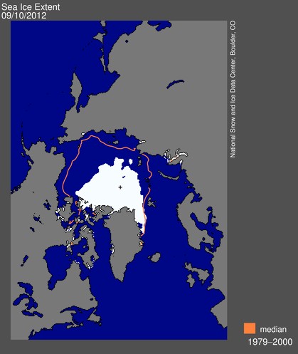
NSIDC’s super-sensitive sensors apparently can’t detect 82 foot thick ice in the Chukchi sea.


I think I can just see it on this map.
http://www.aari.ru/odata/_d0015.php?lang=1&mod=0&yy=2012
Back in the day when I was interested, I used to watch this map. You can see the ice here:
http://ocean.dmi.dk/arctic/satellite/index.uk.php
No you can’t. That’s clearly labelled “sea surface temperature”. The light gray you think is ice is actually sea surface temperature below -1.7*C. I emailed someone (Jacob L. Hoyer) from the website who confirmed that:
“Hi Robert,
I admit it can be difficult to see, but actually the light gray color is in the color bar, in the triangle to the far left.
This means that all temperatures (including sea ice) below -1.7 are marked light gray.
Hope this helped.
Best wishes,
Jacob”
Joe Bastardi has been claiming all week that there’s been a rapid recovery in Arctic sea ice this month by showing the map you linked to. He (and you) made a serious blunder. It’s difficult to see how you did this since you have to physically select “sea surface temperature” among the parameters in order to get the map you posted.
Here is the map from that website (from the DMI/COI) that actually shows the sea ice concentration: http://ocean.dmi.dk/arctic/icedrift_anim/index.uk.php
As you can see, there’s been no recovery this month. In fact, there has been continued melting.
There is plenty of new ice forming now, with temperatures near the pole at -10C. You can’t distinguish melt from compaction by looking at graphs.
Pretty big Ice increase since Aug 26
http://climaterealists.com/?id=10209
-1.7 C is the freezing point of sea water at the salinity of the Arctic Ocean, 31 PSU.
That is of course why they chose that number.
http://upload.wikimedia.org/wikipedia/commons/f/f7/WOA05_sea-surf_SAL_AYool.png
Calculate the freezing point yourself with this calculator:
http://www.csgnetwork.com/h2ofreezecalc.html
My blunder was minor.
How are the Polar Bears going to survice on that small piece ice?
Lance, when is your 100 holes of hell? If not by next week, you might be playing in the snow.
Head out tomorrow! Weekend looks great so far!!
I’m confused????
How can the speed of a non-existent object be tracked?
It´s Heisenberg´s uncertainty principle. If you measure the velocity of ice, it is impossible to track. And if you see it, it is not there.
Very illusive indeed. New Normal Phenomena in Post Normal Science!
Is it now called Dark Ice? Just as no one has seen dark matter or can detect dark energy, you just can’t detect Dark Ice.
Dark Ice is moved by Strange Attactors (An attractor can be a point, a finite set of points, a curve, a manifold, or even a complicated set with a fractal structure known as a strange attractor. See http://en.wikipedia.org/wiki/Attractor), and this proxy for the Dark Ice reveals its movement.
🙂
New ice that is 82 feet thick? Now that is something. 😉
PIOMAS says it will be gone soon. So you have a choice—will you believe the real world or will you believe a computer model?
Sadly, it probably depends on who is writing the checks to pay your mortgage.
And your gas err something.
http://www.youtube.com/watch?v=P36x8rTb3jI&feature=player_embedded