
The rowers are now six weeks and almost 25% of the way through their trip, with sub-freezing weather forecast at Pond Inlet in a few days. Hopefully they brought their steel oars for cutting thorough the metre thick ice when they arrive at Pond Inlet in December.

The waders will be back home this time next month if they don’t find a way to kill themselves on this foolish venture.
Mr owl pointed out a mast they could use to rig a sail. Did they notice? http://mainstreamlastfirst.com/arctic-wildlife/
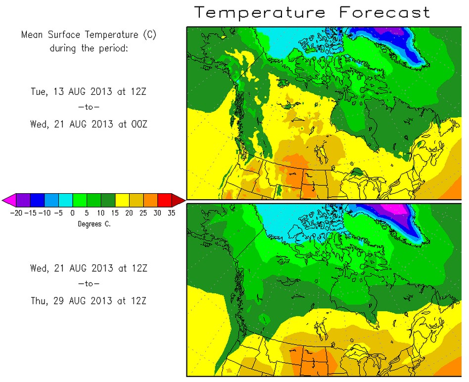
High of 81 in Coppermine tomorrow. Coppermine is south of their route. Maybe. I thought Paulatuk was south of it, too. High of 46 Thursday week. Low approaching freezing. Summer in the Arctic is over.
http://www.weather.com/weather/tenday/Coppermine+CAXX1310:1:CA
Plus, the Gales of November come early. Cambridge Bay showing 20-25 mph winds. No way they can cross to Victoria Island. Unaided, that is. They can’t wade the channel; wind will keep them from rowing across. Set course for Coppermine. Drag on.
It looks dangerous through the strait!
http://arctic.atmos.uiuc.edu/cryosphere/NEWIMAGES/arctic.seaice.color.004.png
Maybe if they’d put tires (or tyres) on the silly thing, they’d manage better.
http://www.youtube.com/watch?v=WNkvASxfEWQ
No 97% melt of Greenland this summer!
They are probably regretting the decision to row rather than use jet skis.
They’ve gone about 230 Km over the last week; an average of about 32-33 Km /Day. At this pace, their big decision at Lambert Island comes in ~6 days; cross the 5 mile gap or stay to the south shore. The second chance decision is at 7 days, Hop across the two smaller islands (Douglas Island) or turn the corner to head toward Kuglutuk (Copper Mine).
The forecast for Eureka has max and min daily temps below freezing starting on the 17th with daily snow possible. Winter is quickly approaching from the North.
Their last ping I can see was over 14 hours ago in the bay on the west side of Cape Young Yellow Knife. There is an airport there, Cape Young IATA (YUI). A road, three buildings and the runway are barely visible on GMaps. That bay appears to be about 600 km by water from Kuglutuk.
The two French Canadian fireman kayakers are pulling further away–already in the Coronation Gulf, approximately 150 km from a hot shower in Kuglutuk.
They would have to be complete idiots to continue. Conditions are going to deteriorate rapidly from here on out.
Looks like tomorrow will be deceptively nice for a ship of fools.
The Rowing Team’s legacy is likely to be similar to Shakleton’s H.M.S. Endurance if they don’t pay attention to the forecast.
http://www.bbc.co.uk/news/science-environment-23682521
How about general cargo ship “Tunis”? It just went from Singapore to the North Pole in about an hour! 🙂
http://www.sailwx.info/shiptrack/shipposition.phtml?call=V2QN8
http://www.marinetraffic.com/ais/shipdetails.aspx?mmsi=304010627
Ship “OS 8154” – which I think is “LE MANGUIER” (but I’ve forgotten why) is on the move.
http://www.sailwx.info/shiptrack/shipposition.phtml?call=OS8154
http://northwestpassage2013.blogspot.co.uk/2013/07/draft-2013-arctic-boat-list-comments.html
If I understand this page correctly… :
http://www.marinetraffic.com/ais/shipdetails.aspx?MMSI=244538000
Greenpeace ice-breaking party-ship “Arctic Sunrise” left Kirkenes on the 11 Aug, heading to a place called “Operational” which it expects to arrive at on the 24 Aug. It’s not reporting its position.
http://www.sailwx.info/shiptrack/shipposition.phtml?call=PE6851
Oceanographic Research sailing ship “Tara” is still heading east, where I think they’re going to find some ice.
http://www.sailwx.info/shiptrack/shipposition.phtml?call=FVNM
http://earthdata.nasa.gov/labs/worldview/?map=56696.029992,621620.599641,1039736.029992,1093684.599641&products=baselayers,!MODIS_Aqua_CorrectedReflectance_TrueColor,MODIS_Terra_CorrectedReflectance_TrueColor~overlays,arctic_coastlines_3413&time=2013-08-09&switch=arctic
(Check the date on the satelite map.)