[youtube=http://www.youtube.com/watch?v=IvmY4RdIWGk]
Disrupting the Borg is expensive and time consuming!
Google Search
-
Recent Posts
- Gaslighting 1924
- “Why Do You Resist?”
- Climate Attribution Model
- Fact Checking NASA
- Fact Checking Grok
- Fact Checking The New York Times
- New Visitech Features
- Ice-Free Arctic By 2014
- Debt-Free US Treasury Forecast
- Analyzing Big City Crime (Part 2)
- Analyzing Big City Crime
- UK Migration Caused By Global Warming
- Climate Attribution In Greece
- “Brown: ’50 days to save world'”
- The Catastrophic Influence of Bovine Methane Emissions on Extraterrestrial Climate Patterns
- Posting On X
- Seventeen Years Of Fun
- The Importance Of Good Tools
- Temperature Shifts At Blue Hill, MA
- CO2²
- Time Of Observation Bias
- Climate Scamming For Profit
- Climate Scamming For Profit
- Back To The Future
- “records going back to 1961”
Recent Comments
- Gordon Vigurs on Gaslighting 1924
- conrad ziefle on Gaslighting 1924
- Robertvd on Gaslighting 1924
- conrad ziefle on Gaslighting 1924
- arn on Gaslighting 1924
- Gordon Vigurs on Gaslighting 1924
- Bob G on Climate Attribution Model
- conrad ziefle on Climate Attribution Model
- Ohio Cyclist on Climate Attribution Model
- Bob G on Climate Attribution Model


Out of their depth, out of their minds.
They were towed!
If I was going to cheat on this trek, I would think about using a sea plane as a tug boat.
Did anyone check what speed they made on that SELY course? That is into the wind.
Check this noon map – SE at 15 knots.
http://weather.gc.ca/data/analysis/jac18_100.gif
On a train bound for nowhere.
http://www.youtube.com/watch?v=8tSo4IICBTY
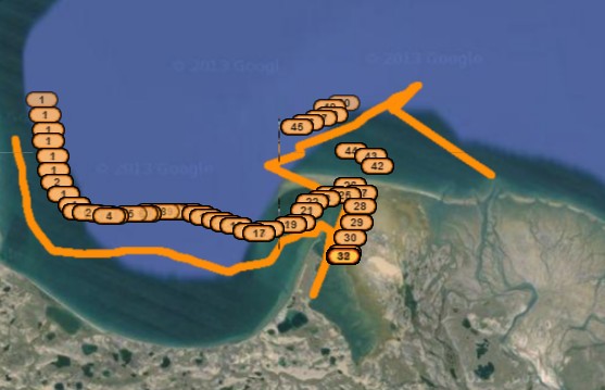
Towards the end of their rowing day it seems they tried to make a direct route out of the bay, but couldn’t beat the wind or ice. 12 hours later, they were back on a beach. They’d better get out of that bay or they stand a chance of the ice pack will move in on them.
Measurable ice is already upon what they called “refuge islet” where they were about 5 days ago.
http://ice-glaces.ec.gc.ca/prods/WIS39CT/20130804180000_WIS39CT_0007195459.pdf
Steve I hope they did no roll over the boat,.???? last GPS signal was 4 hours ago out over deeper water off shore
Maybe they meant that they were going to wade and row the same distance as the North West Passage, not row through the North West passage which they clearly aren’t going to accomplish this year or maybe during any other year for that matter. I only hope that those two precious girls get to see and hug their daddy again.
They are probably being driven to madness by “green” scumbags with a profit agenda.
Hopefully images of those precious girls will persuade their daddy to come to his senses. They are not in a fox hole realizing there really is a God, but at some point at least one will start to break and decide this was supposed to be an adventure, not a suicide mission. I’ll be very surprised if they last two more weeks without one or more cracking under the pressure.
I’m sure Lamestream is applying a lot of pressure to press on.
I’ll bet the draggin’ team signed waivers that completely absolve Lamestream from any responsibility should the team end-up on the wrong side of a floe collision, or polar bear encounter.
The Lamestream corporate publicity hounds are probably sociopaths who will spin the story to benefit Lamestream should the draggin’ team meet an untimely end.
i.e. the rotton slushy first year ice was carried by wind into a large heap that crushed the team. Or starving polar bears & cubs were driven by desperation to attack the sleeping team. The usual warmista rot in any case.
Hmmm…maybe – but – it’s quite disconcerting to think that such a damaged set of genes has been passed on.
If you are into the green agenda thing, doesn’t that make you a rent seeking scallywag instead of a businessman?
Yes.
Maybe they need to put of a sail and iceboat thru the NW Passage.
Did they pick up a replacement anchor in their 28 hour layover?
Here’s some damn good advice for the rowers.
http://www.youtube.com/watch?v=U5PtSJEfajw&feature=player_embedded
It looks like they are hunting with Ray Charles.
I don’t get it: from yesterday’s ‘death spiral’ shaped route I go the bed get up (Day Off) check the mainstream website at 09:42 GMT and the convoluted tracking shape of eight hours ago is now a perfect NEE trajectory.!! WTF is going on?
http://mainstreamlastfirst.com/
Sorry ENE trajectory
OT but something of interest in the latest Satellite photos. A huge area of sea just north of Finland and Norway is currently bright light turquoise blue. I saw something similar once on David Attenborough’s Blue Planet. Would this be the billions of Arctic herring spawning? It’s not ice and not pollution or silt and definitely not methane calthrate.
http://www.arctic.io/observations/8/2013-08-03/8-N69.799485-W125.702951/Canada-Inuvik
Phytoplankton, check out: http://en.wikipedia.org/wiki/Barents_Sea#Ecology
RE: Lawrence13 says:
August 5, 2013 at 8:44 am
If you go to the box at the left of their GPS map and click from “page one” (today’s path) to “page two” you will see yesterday’s odd meandering.
Why did they meander? Your guess is good as mine. Sandbars? Ice floes? Head winds? A slavering, swimming polar bear? A beautiful mermaid sitting on a white berg and playing a golden harp?
Someday maybe they’ll tell us, or maybe they won’t.
Thanks Caleb. I take it the numerical tracking points are for a session of rowing and not the whole trip?