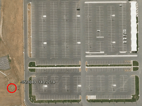
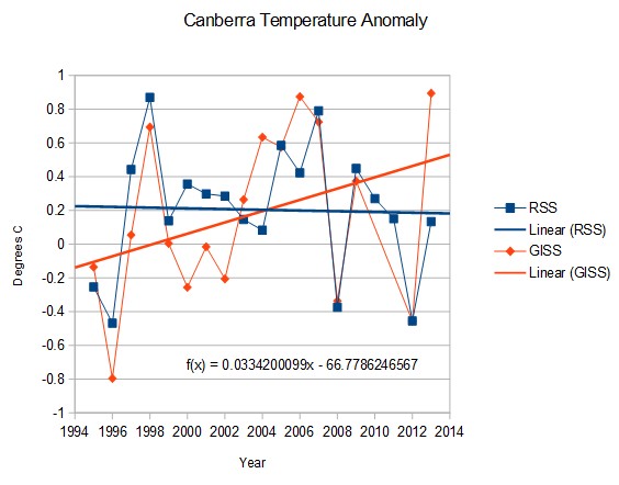
The BOM thermometer at Canberra Airport is cleverly located adjacent to a huge parking lot, and showed 2013 as the hottest year ever. That thermometer shows Canberra warming at 3.3°C/century since 1996
Lower troposphere temperatures measured by satellites above Canberra tell a completely different story. Last year was cooler than average, and is cooling since 1996.


RSS is satellite I thought??
Did you get the labels the right way around?
Of course he did. RSS is declining, GISS is increasing. That’s how it always is.
(GISS doesn’t want us to know that RSS exists.)
When the pot boils, the scum rises to the top.
[Eliot, Belknap Papers, 1777]
The late, great John Daly was onto this in the early 2000’s. He compared the reported temps at Canberra airport vs Wagga Wagga airport. They are both at around the same latitude, except that Wagga is about 250km further inland than Canberra. As anyone with a passing knowledge of Australia will tell you, the further inland you get from the coast, the hotter it usually is. So, what did John find?
http://www.john-daly.com/stations/canberra.gif
A slight upward trend at Canberra compared to Wagga, but pretty similar. Now, want to guess when they built that bloody great carpark? Here’s a graph from Ken’s Kingdom, updated to around 2010:
http://kenskingdom.files.wordpress.com/2010/12/canberra.jpg
It was probably the inefficiency of government bureaucracies in many countries, and not a designed scheme, that resulted in weather stations not being relocated when asphalt jungles grew up around them over the years, sharply skewing (upward) their temperature findings. But now it’s obvious that those in charge are manipulating the data for political purposes. Sad.
Interesting .. if you look at the site photograph on the BoM website, they have taken it facing away from the car park and show the open field.
http://www.bom.gov.au/climate/change/map/stations/070014.shtml
That, right there, is diabolical. They even cropped or framed the shot at the bottom to avoid showing the roadway from which the shot was plainly taken. So if as daveandrews says above those above are simply manipulating data he is seriously understating things. Giving them the benefit of the doubt that this was not a planned program, failing to admit the obvious UHI effect, failing to act to correct the UHI effect, using the UHI as propaganda and then further manipulating the public perception of all of the preceding is, as I said, diabolical.
It is deliberate – they do it on all their airport site photographs.
Cairns, for example:
http://www.bom.gov.au/climate/change/map/stations/031011.shtml
Who would know this was at an airport?
If I had someway to insert photos here I would prove to you that the met station was moved away from the car park prior to 6 May 2011 to a location well away from any asphalt. More recently the car park has been extended to cover the old met station location. If you want the photos just email me and I will send them to you.
That is the lat/lon currently listed on the BOM web site
Let me send you the aerial photos and you can see they have moved the met site. They also appear to have run two site on the AP for a few years for comparison.
The location you are pointing to is now a new extension of the car park. There is clearly no met station there any more. It now closer to the start or runway 30 but still a good distance from it.
Perhaps if actual temps continue to fall, they will try to move the station into the path of the jetwash. That will buy them a little more time to try to convince people that it is warming.
RTF
The problem seems to be that when they relocated the weather station, they also renumbered it.
The RCS listing shows Canberra Airport as #070014, at the Lat/Lon shown in the photo at top.
The BoM Observations page shows Canberra Airport as #070351, at -35.31 / 149.20 – i.e. closer to the runway.
http://www.bom.gov.au/products/IDN60903/IDN60903.94926.shtml
The RCS page has not been updated. I guess their quality control (?) in all things leaves a lot to be desired.
And you can see the drop in temp where GISS mirrored RSS for a few years and then when back to being above RSS again.
So are you saying that they were briefly tempted to tell the truth and then figured, “why change now?”
Who knows why it dropped relative to RSS. But this is a story about UHI, not fake adjustments.
Surely any uhi would have reached maximum when the airport works adjacent to the station were completed? Any idea why temps continue to rise?
Forrest Mims once showed that if you are within a quarter of a mile of a paved road, there is a detectable increase in temperature. It is on the web somewhere.
http://mynasadata.larc.nasa.gov/804-2/measuring-temperature-islands-page-4/
With a Supreme Court like this you might as well make Obummer King and be done with it.
http://fortune.com/2014/06/23/scotus-epa-greenhouse/?xid=ob_rss
http://www.foxnews.com/politics/2014/10/14/emails-show-cozy-ties-between-epa-environmental-group-over-power-plant-rules/?utm_source=feedburner&utm_medium=feed&utm_campaign=Feed%3A+foxnews%2Fpolitics+%28Internal+-+Politics+-+Text%29
Is GISS missing data for 2010, 2011? Why no data points for those years in the GISS series?
Yes, they are missing data
A bit of an update on Ebola And the DemiRats political spin. Remember how we have been reassured by CDC that contact with bodily fluids is the way it spreads and it is not airborne spread?
Well it seems the stuff can survive on surfaces for days and it possibly could be airborne.
CNN in the mean time is bashing Obama’s Admin.
Ebola: Five ways the CDC got it wrong – CNN.com
Remember Ted Turner, founder of CNN said:
“A total population of 250-300 million people, a 95% decline from present levels, would be ideal.”
Mike Savage is really ripping the Obama Admin a new one but then Dr. Savage has a PhD from the University of California and studied epidemiology as well as botany and nutrition. He has been studying epidemics for a long time. Michael Savage: ‘If you like your Ebola, you can keep your Ebola’
The Liberals of course are spinning like mad.
Excuse #47: The Republicans cut funding to the CDC, sniff, sniff, whine. Of course if you read the fine print there was no budget cuts they just didn’t get the increases they wanted so the DemiRats rollout the inflation excuse. (Note this is never mentioned when talking about Obummer and the Economy.)
Pass the buck why don’t you, you @(*^$$H*%& !
More from The Hill:
thehill(DOT)com/blogs/ballot-box/campaign-ads/220576-dem-ad-blames-republicans-for-cdc-budget-cuts
One of the commenters nails the lie to the wall:
I don’t see Ebola anywhere on that list do you?
I hope the Republicans can manage to kill these spin ads fast!
If there are mass quarantines, that will affect the election outcome, because people will not be able to vote. Even by mail, if they should want to. A quarantine in an area will cause ballots mailed in from that area to be quarantined.
Watch for only neighborhoods of a certain type to be quarantined. Watch for Republican leaders going along with it, and claiming that everyone should accept whatever the CDC says.
RTF
If the NIH had more than 10 years working on the problem and many billions of dollars spent already, then don’t bother giving them any more, because clearly they never will finish the job.
Give the money to someone else or better yet just offer a fixed sum to the first private lab that can demonstrate a vacine.
+1
I think if you infected all the NIH scientists with Ebola, they would come up with a vaccine in a couple of hours. It’s all about motivation. Currently they have little.
Anybody see any problems with the location of this RCS weather station?
http://www.bom.gov.au/climate/change/map/stations/046037.shtml
…or this one?
http://www.bom.gov.au/climate/change/map/stations/010592.shtml
…or this one ?
http://www.bom.gov.au/climate/change/map/stations/017031.shtml
Grading of sites plus error HERE
All of those are class 5