
Since 1992, the tide gauge at Atlantic City shows 3.3 mm/year sea level rise, while satellites show 2.1 mm/year. This indicates that the land is subsiding more than 1mm/year.
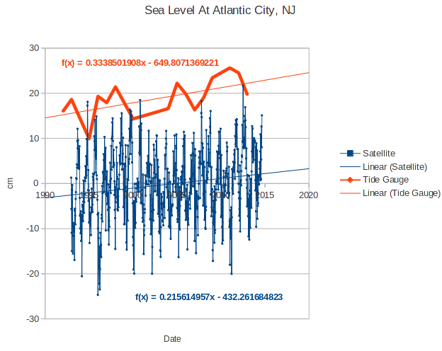 Both are down from the century average of 4.1 mm/year
Since 1992, the tide gauge at Atlantic City shows 3.3 mm/year sea level rise, while satellites show 2.1 mm/year. This indicates that the land is subsiding more than 1mm/year.
Both are down from the century average of 4.1 mm/year

There’s no hope left. Now CO2 can make the land sink? We’re doomed.
mm = millimeters. 25.4 mm/inch. 3.3 mm is about 0.125 or 1/8th inch. Are you suggesting satellites can measure sea level to mm resolution? Or that a tide gauge has mm precision? Or are these both just statistical constructs?
Statistical constructs just like everything else in Climastrology.
It is 3.3 mm +/- 10 feet for satellites (Just kidding but probably closer to reality than anything you would get from a Climastrologist.)
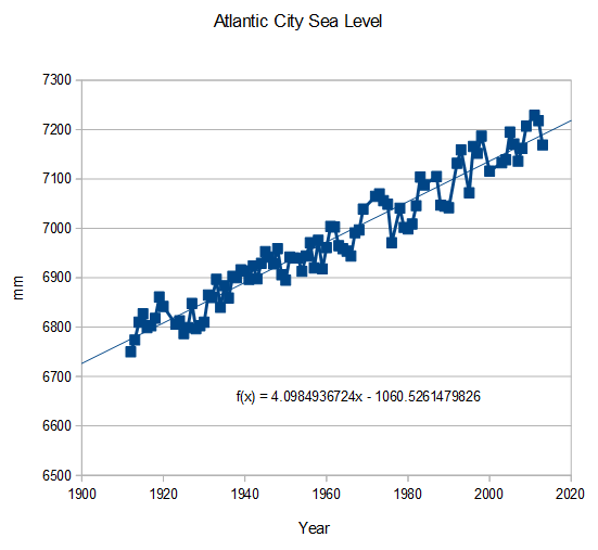
If you run 30 year smoothing on that data you find that there was a peak of 5.6 mm/yr 1921-1950 that by 1966 declined to 2.2 mm/yr but by 2005 had resumed to 6.0 mm/yr. Since then the 30 year rate has declined to 4.8 mm/yr. Overall a rate of 4.1 mm/yr increasing by 0.008 mm/yr.
If you run smoothing for time periods other than 30 years you get different answers none of which get you anywhere near a meter by 2100 or whatever the usual claim is.
By the way, If you figure the rate from 1912 to 1962 it’s 3.9 mm/yr and from 1962 to 2013 the rate drops to 0.05 mm/yr
Atlantic City data:
http://www.psmsl.org/data/obtaining/rlr.annual.data/180.rlrdata
AC is on a barrior beach not rock solid land. It will be always sinking not the sea level rising.
http://tidesandcurrents.noaa.gov/sltrends/sltrends_station.shtml?stnid=8516945 This kings point on more solid land. Sea level has gone down last four years…..trend still up though