
An efficient way to form lots of Antarctic sea ice during the autumn growth season is to have strong winds that push the ice away from the coastline. Pushing sea ice away leaves open water that can lose heat to the atmosphere, creating more sea ice.
Steig is blaming the record Antarctic sea ice on global warming, and then describing it is a negative feedback which is somehow consistent with climate models. That directly contradicts the foundations of Hansen’s feedback theories. Hansen predicted peak global warming of 8°C – right where the peak sea ice gain has occurred in the Weddell Sea.
archive.org/…. epa.gov/climatechange/…./Challenge_chapter2.pdf
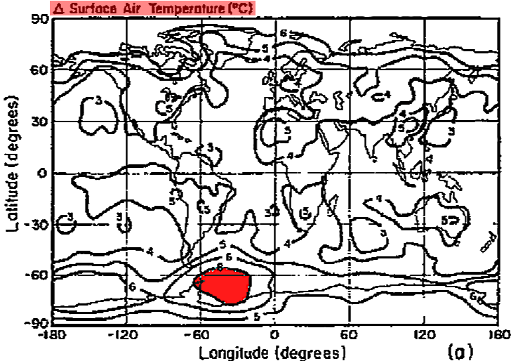
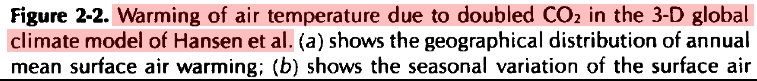
Hansen also predicted peak sea ice loss in the Weddell Sea, right where the peak sea ice gain has occurred.
No, they didn’t predict it all along, and a negative feedback is a direct contradiction of a fundamental tenet of global warming theory.
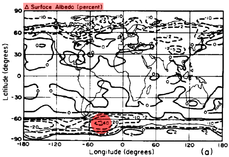
But it is worse than it seems. Not only is Antarctic sea ice at record levels in winter, but it is also at record levels in summer, when the sun is highest in the sky. Thus more sunlight is getting reflected back into space, which further cools the Earth. Another negative feedback, undermining global warming theory.
arctic.atmos.uiuc.edu/cryosphere/timeseries.south.anom.1979-2008
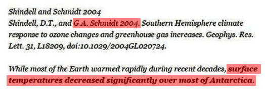
Ten years ago, Gavin reported that temperatures decreased significantly over most of Antarctica.
But it is even worse than it seems. Experts like Walt Meier used to claim that the Antarctic sea ice anomalies occurred only in winter, when it didn’t affect albedo. Obviously that isn’t correct.
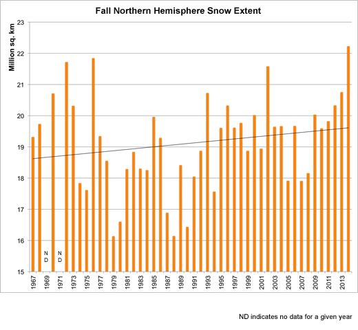
But it is even “worser” than that seems. Gavin claims this is the hottest year ever, with record Antarctic sea ice and near record winter and autumn northern hemisphere snow extent.

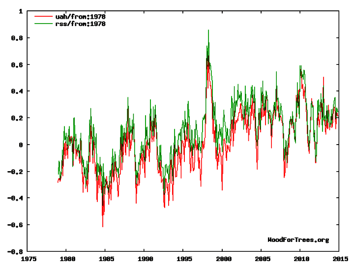
The team also cleverly ignores the fact that satellite data shows the troposphere is nowhere near the warmest on record.
This entire global warming farce is in complete collapse, and they are in full on propaganda mode now. All they have left is fabricating data and making up fake ad hoc excuses.

“All they have left is fabricating data and making up fake ad hoc excuses.”
And an endless army of useless idiots.
It is that endless army that is the problem.
Yes indeed, I deal with a few of those useful idiots at DTT dot com. Once people swallow the AGW meme they seem to be incapable of any independent thought. Their vicious remarks towards Tony, towards myself, show that they have adopted AGW as a religious belief like the type that need an intervention.
CAGW plays into their belief that mankind and particularly those from the USA are EVIL and must be punished. Never mind the fact that if you were to make them live as they want the rest of us to they would throw a temper-tantrum of such epic proportions you would hear it around the world.
They are also completely blind to the fact that the energy generated by wind and solar can not replace all the energy used in building and setting up wind and solar. They are a net energy loss. (But you won’t find many who will tell you that.)
DIT – that is what they use to call the state IT department here, and it was universally reviled. SO they changed their name. But not their reason for revulsion in the first place.
And shouting abuse, of course.
Why on Earth they believe that calling people names is going to advance their cause is a mystery.
Then again, as they are almost without exception “Progressives” AKA Socialists, I suppose it goes with the territory.
Name calling works well for leftists, mainly because pop culture and the media parrot those names, giving them false legitimacy.
“Racist” has been used with great efficacy to silence many discussions, and stopped Americans from possibly solving one of the biggest problems the US faces.
There will not be a solution to the ‘racism’ problem until everyone realizes there is just one race…human. The ‘problem’ is all political.
Yes it is all political and Obama’s favorite …. LOOK A SQUIRREL!
If there were no other issues, the damage Obummer has done to race relations should still put him as the worst president ever.
I was quite surprised that race relations were a heck of a lot worse in the Bastille of Marxism, Boston MA then they are here in hickville NC. We were warned this was KKK territory. The only two KKK members I met were two buddies, one black and one white who spent about an hour educating us dumb yanks. (The black did most of the talking)
I’ll see their racist card and raise them a genocide.
Their burning of food (biofuels) mostly mandated in the name of CAGW has easily caused more deaths from starvation in third world countries than the deaths caused by Hitler’s holocaust.
Gail, down (up) here in WV the only confirmed KKK member I know of is the late Sen. R. C. Byrd…or was that ‘ex-member’ (but I thought KKK was like most things…once a member always a member…).
Snowleopard says:
“I’ll see their racist card and raise them a genocide….”
That is one of my primary reasons for hating the UN and WTO and the IPCC and all the politicians stuffing their pockets with money while deliberately making children starve.
I can not understand how anyone with a conscience can support these people, but they do in droves.
Gail –
Back in the 60s, I believe it was black comic Dick Gregory who said:
“Up North, the whites don’t seem to care how big we get as long as you don’t get too close”
“Down South, the whites don’t seem to care how close we get as long as we don’t get too big”
It’s all a matter of perspective, eh?
The irony? The north’s subjugation of the south assured that blacks had an equal footing. But the rules that “enforced” that were never applied to the north, so it never happened there.
I thought the accepted term was “useful idiots”.
Only the other side considers those idiots useful.
At least both sides agree on the idiots part.
Not useless – but definitely idiots. Every megalomaniac needs useful idiots.
Jim Hansen said that all feedbacks are positive. Nuff said. He also made some great puppets like Kermit and Miss Piggy back in the day.
Well that explains the “The Frogs are Dying” meme.
https://www.youtube.com/watch?v=DbCI68eSNsA
That song works on so many levels.
More great work.
Have you had your Christmas card yet from The Team, Tony? No? Must be stuck in the post, somewhere. Ho ho ho! 🙂
Merry Christmas Sir, you’ve produced some brilliant work this year.
One point missing in that great roundup was covered by RACookPE1978 at WUWT.
Comment on Albedo starting here
ALso see: wattsupwiththat(DOT)com/2014/02/18/how-much-sunlight-actually-enters-the-system/#comment-1571596
Which is why I pay attention to the guy.
Nothing like an engineer to point out the holes.
But it pays the bills. Bad thing is that it is our hard earned money that funds the fraud.
“….In general, Antarctic sea ice forms near the coastline, where upwelling waters cool to the atmosphere. It melts when the winds and currents push it into areas of warmer water to the north. In the summer, it melts pretty much all the way back to the coast.…..”
http://www.realclimate.org/index.php/archives/2014/12/clarity-on-antarctic-sea-ice/
My lord what absolute bovine feces. I guess he missed the Christmas Turkey and the Ship of Fools last year who also made the same mistake of believing the propaganda and not bothering to look at the actual satellite images.
(The winter solstice was Sunday, December 21 so it is summer in the SH.)
http://www7320.nrlssc.navy.mil/GLBhycom1-12/navo/antarcsstnowcast.gif
http://arctic.atmos.uiuc.edu/cryosphere/IMAGES/seaice.recent.antarctic.png
http://arctic.atmos.uiuc.edu/cryosphere/IMAGES/global.daily.ice.area.withtrend.jpg
Here is what the IPCC has said on Antarctica sea ice.
One of the points left out is just where the Arctic and Antarctic are:
A good chunk of the shore line extends beyond 70S
http://cgc1d.wikispaces.com/file/view/Antarctica%20Map.gif/387724148/Antarctica%20Map.gif
The Arctic ocean is pretty much within 70N
https://nsidc.org/sites/nsidc.org/files/images//arctic_map.gif
And that doesn’t even get into the earth’s tilt.
I hope the “Serious Case of The Schmidt’s” isn’t contagious 😉
Steve , Merry Christmas. Your blog is a source of information and entertainment.
I think NOAA is producing a new hockey stick in terms of its renewed version of sea surface temperatures – http://wattsupwiththat.com/2014/12/15/noaa-is-updating-their-sea-surface-temperature-dataset/
Although they claim to use satellite data as a reference, this temperature profile is very different to other profiles. For example, 2014 is suddenly higher than the 2004 – 2009 general level, whereas RSS and UAH show 2014 around the 2004 level. (I know they are measuring totally different things, but the satellites are used as “reference”).
Worse, the new NOAA information suggests 2014 sea temperatures are suddenly higher than 1998’s mega El Niño. Hmmmnn.
This will be / is being used to tout the “2014 as warmest ever meme”, as you have covered many times and as also covered by Judith Curry. http://judithcurry.com/2014/12/09/spinning-the-warmest-year/
BullSchmidt.
Reblogged this on Centinel2012 and commented:
What more can one say their theory is a joke, they know it, and they are trying to hide it with common core science!