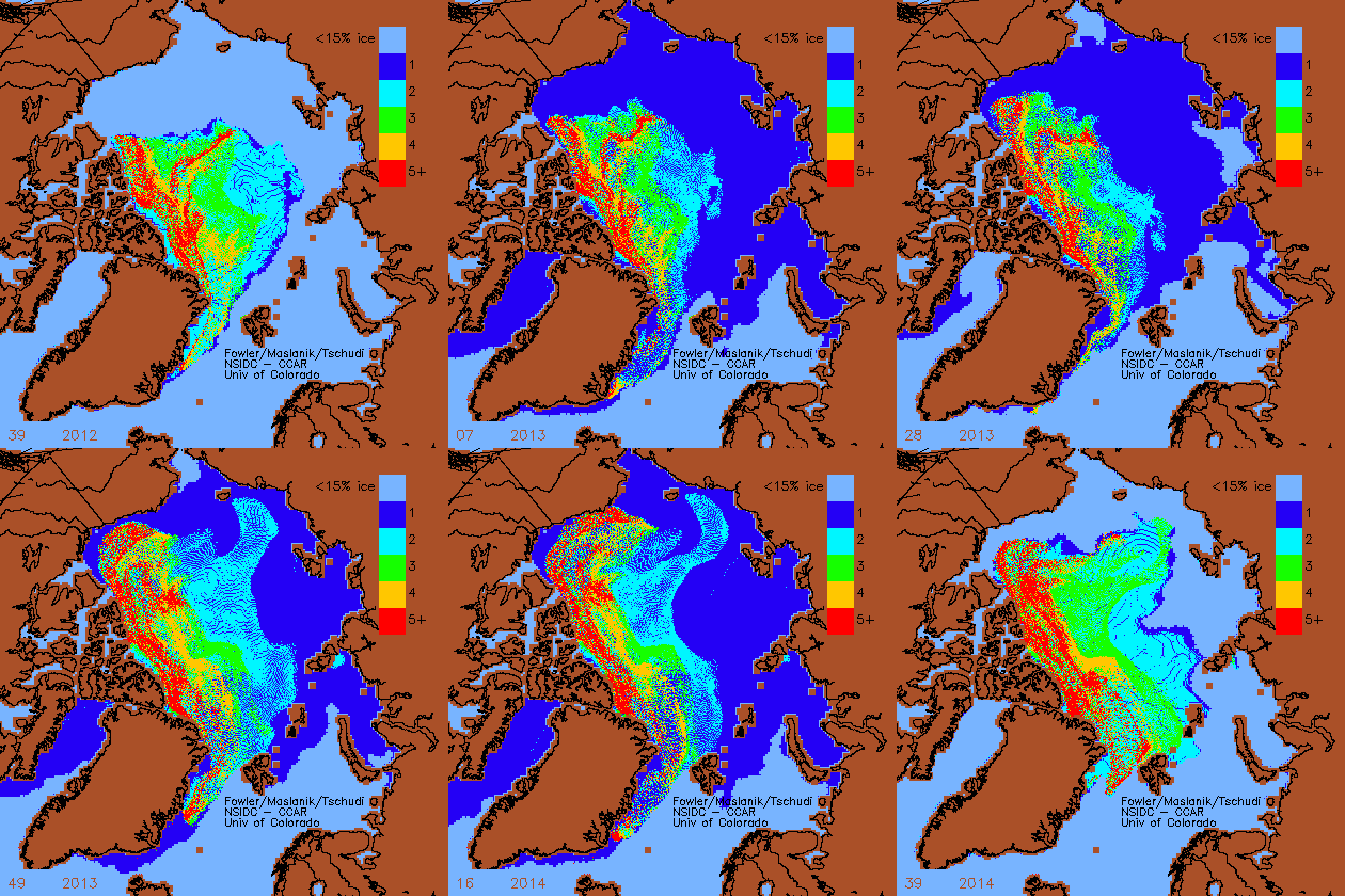
Over the last two years, older thicker ice has been moving into the western Arctic (towards Alaska) making low summer minimums much less likely. Color code shows ice age in years
Disrupting the Borg is expensive and time consuming!
Google Search
-
Recent Posts
- Gaslighting 1924
- “Why Do You Resist?”
- Climate Attribution Model
- Fact Checking NASA
- Fact Checking Grok
- Fact Checking The New York Times
- New Visitech Features
- Ice-Free Arctic By 2014
- Debt-Free US Treasury Forecast
- Analyzing Big City Crime (Part 2)
- Analyzing Big City Crime
- UK Migration Caused By Global Warming
- Climate Attribution In Greece
- “Brown: ’50 days to save world'”
- The Catastrophic Influence of Bovine Methane Emissions on Extraterrestrial Climate Patterns
- Posting On X
- Seventeen Years Of Fun
- The Importance Of Good Tools
- Temperature Shifts At Blue Hill, MA
- CO2²
- Time Of Observation Bias
- Climate Scamming For Profit
- Climate Scamming For Profit
- Back To The Future
- “records going back to 1961”
Recent Comments
- Bob G on Gaslighting 1924
- Bob G on Gaslighting 1924
- conrad ziefle on Gaslighting 1924
- Bob G on Gaslighting 1924
- Bob G on Gaslighting 1924
- arn on Gaslighting 1924
- conrad ziefle on Gaslighting 1924
- Gordon Vigurs on Gaslighting 1924
- conrad ziefle on Gaslighting 1924
- Robertvd on Gaslighting 1924


The real fun begins when the 5+ year ice reaches the Berents sea!
Barents Sea.
Bearenstein Bears sea?
THis is cool but it also shows that a lot of thick multi-year ice escaped the Arctic by moving down the east coast of Greenland in the Greenland Sea between Svalbard and Greenland.
If it didn’t do that, the Arctic Ocean would be full of ice thousands of feet deep.
Really? There is so much ice being pushed toward the Greenland – Canada – Alaska shores that some of it (not “a lot”) spills into the bigger sea, and you notice the trickle leaving? Look at the big picture.
Sea-ice is *almost* always leaving the Arctic basin via the Fram Strait. It is the amount which is important. If you compare the last two years to say, 1988-1996 which ice transport was extremely high, you’ll get a sense of how low it has been the last two years.
Like the comments here ( http://wattsupwiththat.com/2014/10/06/real-science-debates-are-not-rare/#comment-1756825) about ENSO, the ice at the North Pole is the product of not only temperature and ocean current but also the unique geography (i.e. the shape, or even the overall geomorphology) of the area. IMO the ice accumulation is a product of the wind, ocean currents, and temperture and their unique circulatory interaction with these topographic features.
That’s to say the North Pole’s unique characteristics determine how and when ice accumulates and disperses more than Hansen’s lunatic hypothesis that the Arctic is somehow a predictor of global conditions. The condition of the Arctic does not predict anything it is only affected by what is current.
There’s something hokie about this animation. I keep staring at the yellow bands, expecting them to turn red. 4 year old ice (yellow) should turn to 5 year old ice (red) within a year. It doesn’t.
It does. Look when the ice finishes contracting. You see a discontinuity in the colors. It happens twice, one at about the middle of the animation, and again at the end.