Guest Post By Joe Bastardi
No question this a field day for the heat, and part of the reason is a) its darn hot and b) there was a wild weather event that occurred with the Derecho. But for the people convinced that these events are a sign of an AGW apocalypse , try to answer these questions
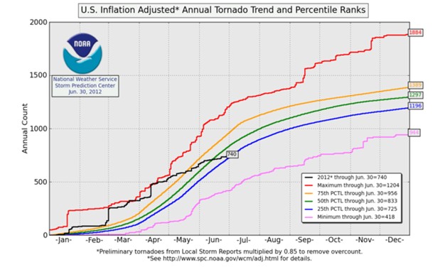
After big tornado outbreaks to start the year and then in mid April. What happened to that? Recall the hysteria that was occurring with it, saying here we go again. Since I stated loudly the tornado season would go into the tank, I think I have the right to ask you where did they all go. From the fastest start ever, we are now near the 25% of normal range, meaning since then, and even with the mid April outbreak and extra tornadoes form Debby, this has probably been a top 5 slow April and May Opposite of last year, and may I remind you on National TV, I said would be one of the busiest Aprils and Mays on record.
SO if its your precious AGW, how did I, who does not believe a lick in it, nail the forecasts of the big event , and then the crash we see this year, if it is because of what you seem to think? I am sorry for the apparent “tooting” of my horn, but again forecasts before the facts based on sound meteorology trump voodoo agenda driven explanations after.
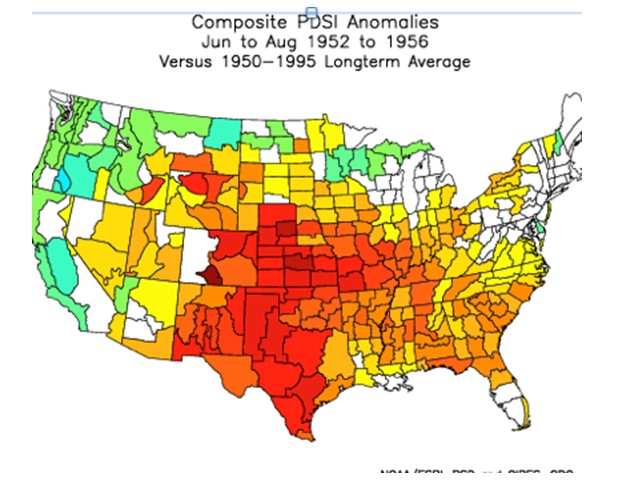
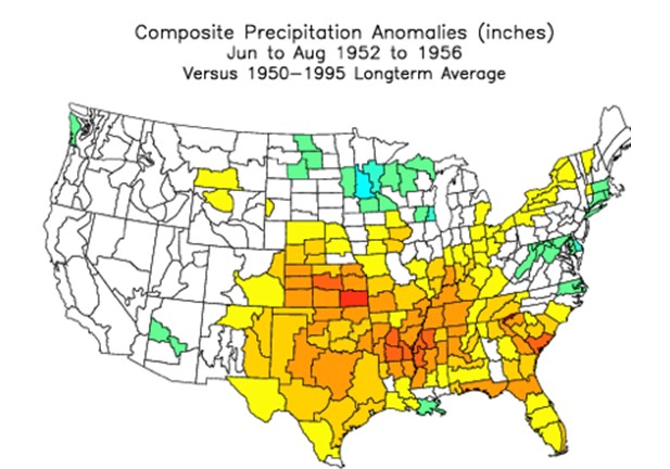
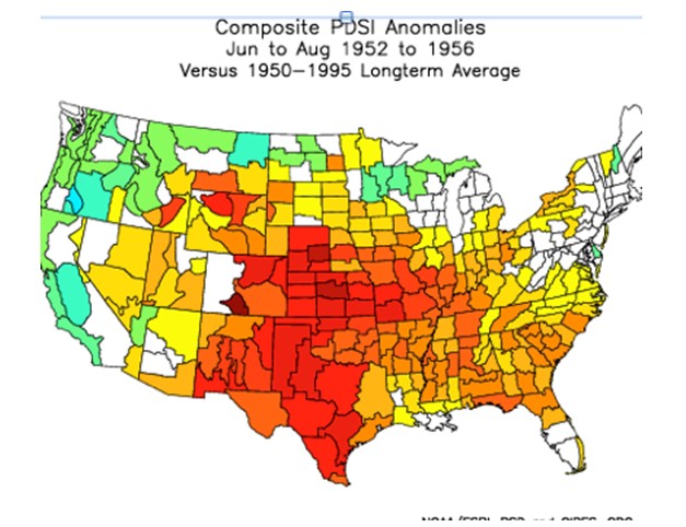
The heat. Very impressive, no doubt. Much like the last time the PDO flipped to cold while the amo was warm.. in the 1950s
Palmer Index Summers 52-56
Precip summers 52-56
Temps summers 52-56
I am not going to bring up the 1930s but the extremes of this heat wave , with 105-110 in much of the deep south IS NOT AS IMPRESSIVE AS THE AUG 1975 heat wave in New England. Its one thing for Atlanta to hit 106 for an all time record , but the Massachusetts record high of ONE HUNDRED AND SEVEN was set in Aug 1975 ( co2 was much lower) This is a far greater extreme meteorologically because of the geographic location of New England. Keep in mind within 2 years of this event ( I still am stunned at how hot it got with that) there was talk of an ice age coming. I am confident that we will see the return of cold , as it did in the late 1950s el nino after the la ninas, and of course like 2009 that will be blamed on Global warming.
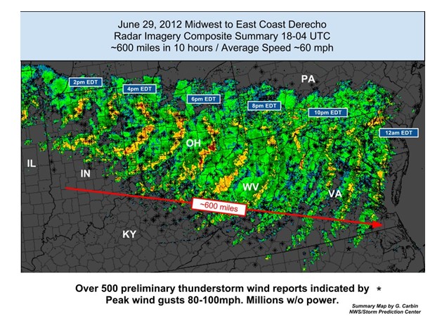
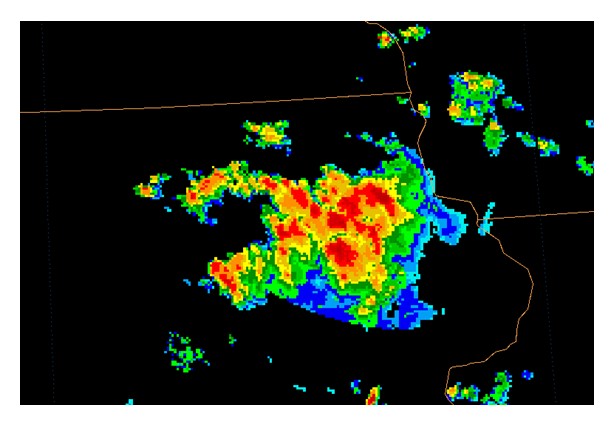
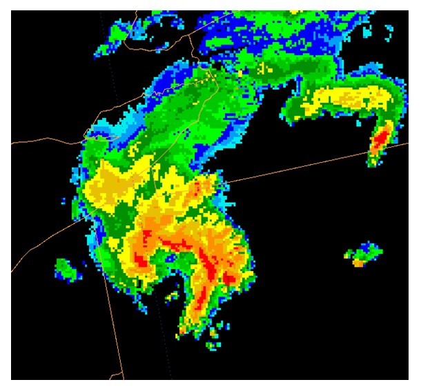
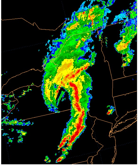
But there is more. The Derecho was IMPRESSIVE AND WILD..
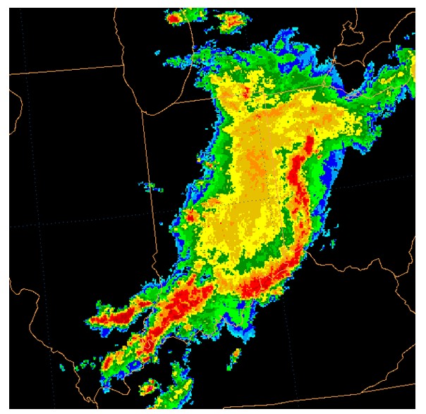
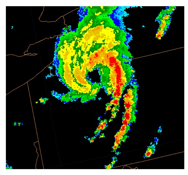
But did it beat what happened meteorologically July 21,2003
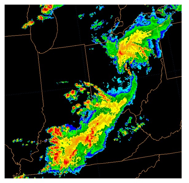
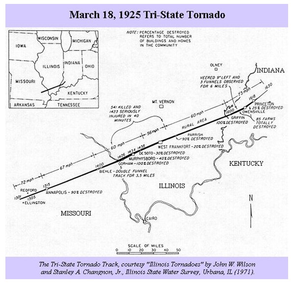
Or the 1925 Tri State Tornado
And speaking of hurricanes… oh we weren’t, but we are now, as happens almost all the time when people open their mouth about AGW induced weather events, the hurricanes have gone south. But to refresh your memory, which is the more extreme event METEOROLOGICALLY a hurricane that drives 13 feet of water into Providence Rhode Island with a 5 minute wind speed at the height of Skyscraper in Boston of 121 mph WITH A GUST TO 186, or big hurricanes hitting the gulf coast like we say in 2005 and 2008. And by the way, the hurricane hits of the back to back 1915-1916 seasons matched 04-05 anyway. But when we are talking extremes of the weather, hurricanes like 1944 and 1938, with the ferocity so far north are more impressive than anything we have seen south of 30 north in the AGW hysteria age against established normals. In fact one has to wonder, why we have not seen them.
Downtown Providence.. Not New Orleans which is in some places under sea level on the gulf, but a city near 42 north , in the 1938 hurricane
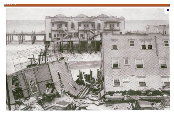
Here is a shot of Ocean City NJ after the 1944 hurricane
There is no question the weather has been extreme the past week, though you have not heard the media and the climate charlatans mention all the record cold that has also occurred. But if people are ignoring the fact that more extreme examples of weather have occurred in the past its either because they are ignorant and don’t know, or do know and wish to deceive their audience with what they are saying. Either way it is a sign of someone not willing to actually tell the truth about what has happened in the past and is trying to take advantage of those that they think they can sway.
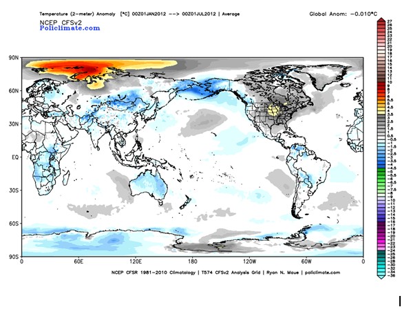
As hot as it is, globally ncep temps remain a minus .01 for the year against the 30 year running mean which is against the start of the satellite era
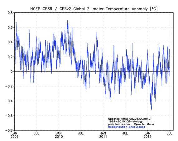
and since the pdo flip, against the 30 year mean, a jagged retreat of temps is evident here
You be the judge,. I WANT YOU TO LOOK AND CHALLENGE YOURSELF TO FIND THE TRUTH, not assume you wont and just will accept what is written and march along like sheep.



Thanks Joe for articulateing what sensible people already understand. And thank you Steven for again having him here. CO2 drives nothing and we who think clearly are very weary of hearing the hype and stupidity of the agw promoters. Joe , I see you are getting your forecasts better tuned as you learn more in your search for understanding weather. I for one appreceate the effort you put into being reliable and will continue to consider what you say as a very possible scenareo of what the weather will be weeks and months out. I trust none of the forecasters who come from the global warming camp as their record of forecasting is continual fails. Having an idea of what the weather might bring a few months out is helpfull in making farming decisions and as expect you are right about the cold I am laying in the firewood. Those who have only electricity to heat their homes might be in trouble in the coming winter what with the poor decisions we are seeing the leadership make.
Reblogged this on Climate Ponderings.
http://seekingalpha.com/article/685061-the-midwest-drought-will-heat-spread-east-and-which-markets-may-it-affect?source=google_news
Thought it was interesting.
Some how the Providence Picture did not get in there, I had two of Ocean City NJ. Look at this link for some photos of what happened there, which is another event I have a tough believing could happen ( the 1938 hurricane) even though it did
http://www.google.com/imgres?imgurl=http://www.oocities.org/hurricanene/38new2.jpg&imgrefurl=http://www.oocities.org/hurricanene/hurr1938.htm&h=402&w=650&sz=80&tbnid=MfvoL15LympM9M:&tbnh=72&tbnw=117&prev=/search%3Fq%3Dprovidence%2BRI%2B%2B1938%2B%2Bhurricane%2Bpictures%26tbm%3Disch%26tbo%3Du&zoom=1&q=providence+RI++1938++hurricane+pictures&usg=__RMrCslFNDdMqba3LZC_WYE8NGR4=&docid=64k_HeBYnWeoqM&sa=X&ei=ntXxT4rjCYna0QGlrv36Ag&ved=0CEUQ9QEwAA&dur=304
Hard to fathom something like this
Incorrect links and copy/paste failures seem to be a feature of WordPress. I’ve seen similar occurrences on other sites.
Joe,
I just want to say “Thanks!” for your intelligent, insightful, yet easily understood, examinations of weather/climate phenomena. All that along with the guts to put it right out there for people to read and see without all the weasel-words from most everyone else. You’re a gem, Joe, and I appreciate you taking the time to educate others through your posts.
Thanks to you too, Steve, for working with Joe to get these posts.
Keep up the great work!
Good explanation Joe one day people will understand. Since pdo turned cold detroit set all kind of snowfall records. Here’s a few most march snow most February snow 6out of 10 years 60″ or more of snow
Snowiest back to back winters 07-08 08-09 137″ 2000-2009 16 storms 6 +” of snow. six calendar months saw
21+” of snow in less than 3 years. Only happened 30,times from 1880-2007. 5 of top ten Snowiest winters happened from 2000-2011. I remember being told I’m the mid-1990 in school that. Because of global warming the winters would have less snow and cold in Detroit but they were wrong keep the information coming to the public Joe.
Great writeup, Joe!
I am now in College Park, MD into my 4th day with no power, air conditioning, hot water, Internet, cable TV, etc. At least I am able to hide out in my office that does have power. I admit, I don’t like living a 19th Century lifestyle, especially no air conditioning with 100 degree heat.
The local media is hyterica about the Derecho l with the word “unprecedented” being thrown about. But anyone checking the record can find many comparable episodes.
Similar events in DC during Juily 1965, July 1976 and June 1989, each producing 70 mph winds and hundreds of uprooted trees.
In June 1954, Derecho swept down all the way from Wisconson to DC after a 100 degree day. Almost the exact same damage as last Friday night with trees uprooted all over Washington, DC and 70 mph winds
During June 1929, a similar storm in DC broght 100 mph winds and widespread damage.
In July 1913, a severe DC storm blew in windows at the White House and blew down multiple trees on the grounds. Thirty huge windows were shattered at the Department of Printing and Engraving and 1000 $1 bills were blown out of the building. A three story building at 7th and L Sts. collapsed, resulting in 2 deaths.
On July 4, 1874, whole city blocks were unroofed in Washington, DC, when a Derecho made a path of death and distruction from Lake Erie to DC.
(Reference from Washington Weather, 2002)
Anyone who checks the records will see that there is very little unprecedented about the current storm.
Another demonstration (always appreciated) that these people make their claims in bad faith. The real question to my mind is, what is the basis of this “bad faith”? I prefer not to speculate, but it doesn’t look to me like it’s outright intentional deception in most of these cases. (I’d actually feel better if it were.)
“I WANT YOU TO LOOK AND CHALLENGE YOURSELF TO FIND THE TRUTH, ..”….. nah, they won’t. There seems to be few and fewer hardcore CAGW believers. The ones left are very dedicated leftists and the others who will refuse to admit they were wrong.
Excellent write-up, a fine piece of work.
Thanks Joe, always appreciate your insight, I’ve learned so much from you!! Keep up the good work!!
This is kind of off topic, but did anyone see the merger between the weather undergound and TWC? Looks like more climate change BS from Dr. Masters, and more liberal propaganda going brainwash the public into believing in CAGW, which will make things a little tougher for us skeptics.
I happened to see a bit of Kevin Trenberth on PBS Newshour tonight interviewed by Judy Woodruff. He was quick to blame all the recent years of extreme weather as what “we” (meaning he and his like minded colleagues) expect in a world warming caused by human intervention and gave the examples of Russia, Texas, Australia heat waves etc, and the current “unprecedented” heat wave/storms in the U.S. at large. Of course Judy Woodruff with all the seriousness of an objective journalist, asked the tough questions such as “what does all this mean”?
Oh yes, I almost forgot. Trenberth also explained how the mountains in Colorado (IIRC, could have been in general) used to have snow on them to help cool the atmosphere and bring water to the lower altitudes in summertime, but now that doesn’t happen because AGW has screwed it all up, so heat waves will be the new normal. but I fell asleep. Judy had such a serious “OMG” look on her face during his answers. There was more, but I fell asleep.