
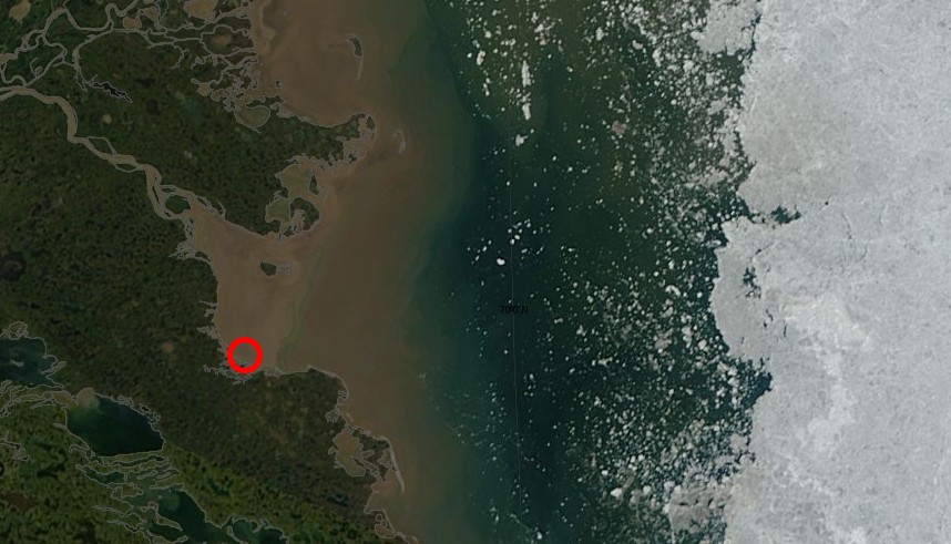
Reggie thinks that the brown McKenzie River delta mud they have been stuck in this week (red circle below) is in the Beaufort Sea
Reggie also wants the rowers to launch their little boat into an ice pack of thousands of massive chunks of constantly moving and shifting ice, so that Reggie can collect whatever financial reward he has tied up in this.
The rowers said this morning that they were hoping the wind would break up the ice blocking their path, but perhaps they can complete their Northwest Passage voyage while sitting in the McKenzie River delta.

The brown is sediment being carried by 20000 cubic meters of water per second being discharged from the Mckenzie River into the Beaufort Sea ever
You better report the error to google
http://econnexus.org/wp-content/uploads/2013/07/2013-07-10_Joule_Beaufort.png
Steve, are you going to correct this error downstairs?
“Wind is blowing large amounts of ice (red below) into the intended path of the rowers”
.http://stevengoddard.wordpress.com/2013/07/12/rowers-path-to-the-beaufort-sea-blocked-with-ice/#comment-248347
Reggie, do you have any response to the second paragraph of the present post?
2nd paragraph:
“Reggie also wants the rowers to launch their little boat into an ice pack of thousands of massive chunks of constantly moving and shifting ice, so that Reggie can collect whatever financial reward he has tied up in this.”
RTF
What ice is that? The rowers posted photos on the Facebook page of their arrival in Tuk and there was no ice to be seen. Maybe if Steve was honest he would have posted a photo from today that was zoomed in, or at least given his readers a sense of scale.
Steve, how old is that photo?
Are you then confirming that there is a financial reward for you that hinges at least in part on whether the team proceeds out from Tuk by water? RTF
No, I wasn’t confirming that.
Fine, but is it true?
Reggie is thinking that they are going to row through the NW Passage without leaving the McKenzie River delta.
Reggie, you deny that the are not yet in the Beaufort Sea and that their route is blocked by ice.
From the horses mouth:
11 Jul 13 – Posted by Mainstream:
“We’re moored within a rolling green grassland broken by small lakes and inland waterways. There are no trees here, only pingos rising out of the landscape surround. These low lying grassy hills – distinctive in this region of the Mackenzie delta – rise several hundred feet and are formed by ice pushing up from beneath. ” – so they ARE still in the delta and haven’t reached the Beaufort Sea.
“And the forced break may be a blessing in disguise too. Ice still blocks our route ahead “
Ice does block their route, about 200km east of Tuk.
Do you now what pingos are, they haven’t been part of a delta since the last ice age.
Pingo Canadian Landmark is in the geological structure called the Beaufort-Mackenzie Basin. For at least the last 100 million years, this area has received sediments from the Richardson Mountains and other more or less extinct landforms around the Mackenzie River. The bedrock in the Tuktoyaktuk area formed from these sediments and is made up of both sandstone and shale. The youngest bedrock is the so-called Beaufort Formation, which contains a range of material from gravel-sized particles to clay.
Above the bedrock lie thick deposits of sand, capped by mixed sediments left by the last glacial advance. The sands form two layers. The lower layer is a grey, well-sorted, medium-grained deposit – called the Kidluit Formation – which was probably deposited in a broad alluvial plain. Above these Kidluit sands is a brown, fine-grained layer called the Kittigazuit Formation. This formation is thought to be the deposits of a large delta, but also includes sand that was blown around in the cold, dry climate leading up to the last glaciation. These sands are exposed at Peninsula Point, where Kilutqusiaq Pingo has been cut and eroded by the ocean. They also underlie the massive icy beds found in the area.
Above the sand layers is mixed sediment, called glacial till, which is a direct remnant of the last ice sheet to cover the region. The massive ice at Peninsula Point formed between the Kittigazuit sands and the glacial till. The top of the massive ice lies between one and ten metres below the ground surface.
http://www.pc.gc.ca/eng/docs/v-g/pingo/index.aspx
Row, row, row your boat gently down the stream. Fun for the feeble minded! Trust me, they will show up somehow, even if they don’t row a mile. Or even a kilometer for that matter.
Salt water Reggie, salt water.
That’s what makes a sea a sea, an ocean an ocean.
Not an estuary.
If the “Rowers” would just hook THIS boat to their other boat, they could begin travelling right away.
http://www.shawneemt.com/contact/press/press_photos/whatsnew0910_groomer_large.jpg
I had to look up “Brawndo” and now I understand Reggie, For those who don’t know, it’s the drink of the stupid masses in the movie Idiocracy. http://en.wikipedia.org/wiki/Idiocracy
We are all on a journey, me, you, Reggie and the 4 rowers. The rowers are just beginning to face a reality that is not in complete agreement with their belief. I appreciate that Reggie is on this board defending his beliefs. Maybe he can learn a little something of real science, as we all can.
I just hoping that no-one has a life insurance policy on the rowers. It looks like they might be pushed into an extremely dangerous trip, without any hope of actually making it. Who is going to pay to rescue them?
Don’t feed the troll.
pure comedy, thanks Regg