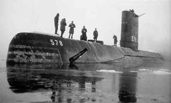
Skate (SSN-578), surfaced at the North Pole, 17 March 1959
Disrupting the Borg is expensive and time consuming!
Google Search
-
Recent Posts
- Gaslighting 1924
- “Why Do You Resist?”
- Climate Attribution Model
- Fact Checking NASA
- Fact Checking Grok
- Fact Checking The New York Times
- New Visitech Features
- Ice-Free Arctic By 2014
- Debt-Free US Treasury Forecast
- Analyzing Big City Crime (Part 2)
- Analyzing Big City Crime
- UK Migration Caused By Global Warming
- Climate Attribution In Greece
- “Brown: ’50 days to save world'”
- The Catastrophic Influence of Bovine Methane Emissions on Extraterrestrial Climate Patterns
- Posting On X
- Seventeen Years Of Fun
- The Importance Of Good Tools
- Temperature Shifts At Blue Hill, MA
- CO2²
- Time Of Observation Bias
- Climate Scamming For Profit
- Climate Scamming For Profit
- Back To The Future
- “records going back to 1961”
Recent Comments
- Bob G on Climate Attribution Model
- conrad ziefle on Climate Attribution Model
- Ohio Cyclist on Climate Attribution Model
- Bob G on Climate Attribution Model
- Bob G on Climate Attribution Model
- Bob G on Fact Checking NASA
- arn on Climate Attribution Model
- Bob G on Climate Attribution Model
- Bob G on Climate Attribution Model
- Bob G on “Why Do You Resist?”


March??………………
But we all know the NH ice was much healthier back then…Tamino showed it!
http://tamino.wordpress.com/2010/10/16/history-of-arctic-and-antarctic-sea-ice-part-1/
What I love is how he claims that the SH ice has dropped a ton from 1940 to the last 1970s, but that claim is in apparent conflict with his claim at another time that modern global warming started in 1975.
-Scott
Seadragon US submarine at North Pole 1962
http://navsource.org/archives/08/0858411.jpg
HMS Investigator got trapped in ice on the last leg of the North West Passage in 1853
http://www.msnbc.msn.com/id/38459028/ns/technology_and_science-science/
ummmm, March of 1959 you say? Just around the peak Arctic extent.
I wonder what it looked like up there that year in September.
Sereze? Julienne? Bueller? Anyone?
the poor bears…or is it polar bears?
We should be wary of Arctic ice claims until the satellite data will be able to show the polynyas
It’s a nice bright day in that picture, normally it is dark around that time of year at the North Pole isn’t it?
The sun would be just coming up, and it looks foggy.
Yes, that would explain it. I wondered if they had used another “library” photo which had more water in it than they actually encountered. Certainly a lot of water there for that time of year.
Andy
Pingback: 24 Hours of Climate Reality: Gore-a-thon – Hour 10 | Watts Up With That?