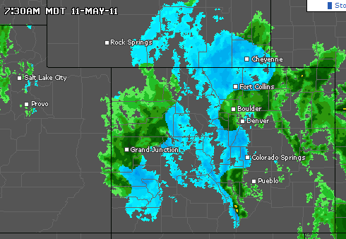
The mountains of Colorado and Wyoming already have near-record snowpack, and are getting lots more today. This is because of the early spring and declining spring snowpack which the models predicted.
Disrupting the Borg is expensive and time consuming!
Google Search
-
Recent Posts
- The Real Hockey Stick Graph
- Analyzing The Western Water Crisis
- Gaslighting 1924
- “Why Do You Resist?”
- Climate Attribution Model
- Fact Checking NASA
- Fact Checking Grok
- Fact Checking The New York Times
- New Visitech Features
- Ice-Free Arctic By 2014
- Debt-Free US Treasury Forecast
- Analyzing Big City Crime (Part 2)
- Analyzing Big City Crime
- UK Migration Caused By Global Warming
- Climate Attribution In Greece
- “Brown: ’50 days to save world'”
- The Catastrophic Influence of Bovine Methane Emissions on Extraterrestrial Climate Patterns
- Posting On X
- Seventeen Years Of Fun
- The Importance Of Good Tools
- Temperature Shifts At Blue Hill, MA
- CO2²
- Time Of Observation Bias
- Climate Scamming For Profit
- Climate Scamming For Profit
Recent Comments
- Francis Barnett on The Real Hockey Stick Graph
- Bob G on The Real Hockey Stick Graph
- Bob G on The Real Hockey Stick Graph
- arn on The Real Hockey Stick Graph
- Bob G on The Real Hockey Stick Graph
- arn on The Real Hockey Stick Graph
- Bob G on The Real Hockey Stick Graph
- Bob G on The Real Hockey Stick Graph
- Gordon Vigurs on The Real Hockey Stick Graph
- arn on The Real Hockey Stick Graph


Northern mountain snowpack is up, but we have had a very dry season on the Front Range. This moisture is very welcome indeed.
You mean along the plains adjacent to the Front Range? I drove up to Cameron Pass on Sunday, and there was incredible amounts of snow. I anticipate flooding along Boulder Creek, similar to 1995.
Just east of the foothills (a few miles) was indeed a dry winter, thankfully!
I’m glad to get the recent rains though, stuff is just as green or greener than normal now, with little sign of letting up. At this point, looks like we’ll stay green until at least June, which is average…even later than that would be great!
Also, glad to see that we’re getting some spring this week. Went from winter to summer (last week), now regressed a little. 🙂
-Scott
Another major Pacific storm will be slamming into the West Coast this weekend with it cold enough for more substantial snows at the ski resorts. Basically a cool weather pattern for the next week or so over the US.
There were several record highs in Iowa yesterday, apporaching 100 degrees, but that should not last very long.