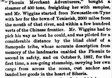
I’m guessing no GPS, lights, sonar, Internet, phones or satellite maps.
Disrupting the Borg is expensive and time consuming!
Google Search
-
Recent Posts
- Gaslighting 1924
- “Why Do You Resist?”
- Climate Attribution Model
- Fact Checking NASA
- Fact Checking Grok
- Fact Checking The New York Times
- New Visitech Features
- Ice-Free Arctic By 2014
- Debt-Free US Treasury Forecast
- Analyzing Big City Crime (Part 2)
- Analyzing Big City Crime
- UK Migration Caused By Global Warming
- Climate Attribution In Greece
- “Brown: ’50 days to save world'”
- The Catastrophic Influence of Bovine Methane Emissions on Extraterrestrial Climate Patterns
- Posting On X
- Seventeen Years Of Fun
- The Importance Of Good Tools
- Temperature Shifts At Blue Hill, MA
- CO2²
- Time Of Observation Bias
- Climate Scamming For Profit
- Climate Scamming For Profit
- Back To The Future
- “records going back to 1961”
Recent Comments
- John Francis on “Why Do You Resist?”
- conrad ziefle on Gaslighting 1924
- Bob G on Gaslighting 1924
- Bob G on Gaslighting 1924
- Bob G on Gaslighting 1924
- conrad ziefle on Gaslighting 1924
- Bob G on Gaslighting 1924
- Bob G on Gaslighting 1924
- arn on Gaslighting 1924
- conrad ziefle on Gaslighting 1924


Dear Steven,
If you acTUAlly bothered to read THE article, you’d SEE that “within a few hundred verts of the Chinese frontier”. I dare you TO refute that WITH facts.
Signed,
Doughy Toucan
The GPS and satellite maps were of to low a resolution to be of much use. I would also hazard a guess that the vessel was not a nuclear powered ice breaker class freighter!
After all a nuclear powered ice breaker class freighter is just a modern day version of an ocean going steam ship. It just uses a little different method of heating the water.
Actually, back then metallurgy was so poor we had to use wooden satellites for navigation. Sometimes it gets pretty dry up there in space and the satellite will warp, throwing off all the navigation signals (it is rather heavily dependent on the length of the telegraph wires remaining constant to insure an accurate reckoning). I ended up in Biafra one time when I meant to sail to Bongo Toga!
This is a cool one!!