Disrupting the Borg is expensive and time consuming!
Google Search
-
Recent Posts
- Gaslighting 1924
- “Why Do You Resist?”
- Climate Attribution Model
- Fact Checking NASA
- Fact Checking Grok
- Fact Checking The New York Times
- New Visitech Features
- Ice-Free Arctic By 2014
- Debt-Free US Treasury Forecast
- Analyzing Big City Crime (Part 2)
- Analyzing Big City Crime
- UK Migration Caused By Global Warming
- Climate Attribution In Greece
- “Brown: ’50 days to save world'”
- The Catastrophic Influence of Bovine Methane Emissions on Extraterrestrial Climate Patterns
- Posting On X
- Seventeen Years Of Fun
- The Importance Of Good Tools
- Temperature Shifts At Blue Hill, MA
- CO2²
- Time Of Observation Bias
- Climate Scamming For Profit
- Climate Scamming For Profit
- Back To The Future
- “records going back to 1961”
Recent Comments
- Bob G on Gaslighting 1924
- Bob G on Gaslighting 1924
- conrad ziefle on Gaslighting 1924
- Bob G on Gaslighting 1924
- Bob G on Gaslighting 1924
- arn on Gaslighting 1924
- conrad ziefle on Gaslighting 1924
- Gordon Vigurs on Gaslighting 1924
- conrad ziefle on Gaslighting 1924
- Robertvd on Gaslighting 1924
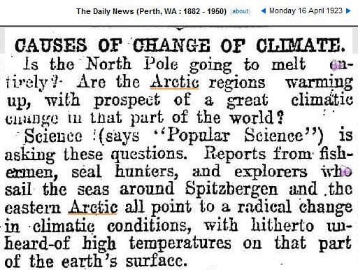
1923 Shock News : Radical Climate Change Melting Down The North Pole
This entry was posted in Uncategorized. Bookmark the permalink.


And the article continues…
“The expedition sailed as far
north as 81deg. 20min. N. latitude in ice
free water. Such a thing, hitherto, would
have been deemed impossible.”
Looks like that’s about 1 degree further South than the ice edge today.
http://www.iup.uni-bremen.de:8084/ssmis/arctic_SSMIS_nic.png
http://stevengoddard.wordpress.com/2012/08/21/1935-russian-ship-sailed-500-miles-from-the-north-pole-in-ice-free-water-2/
And it may have been a lot different in the past. But “real scientist” wouldn’t wont to look there.
http://www.detectingdesign.com/ancientice.html
Here is a map from 1923:
http://brunnur.vedur.is/pub/trausti/Iskort/Pdf/1923/1923_08.pdf
And here is a map from yesterday:
http://www.iup.uni-bremen.de:8084/ssmis/arctic_SSMIS_nic.png
A few minutes ago you were complaining that you couldn’t see the ice edge in today’s satellite photo. The satellites in 1923 were much better.
How come your map shows no ice on Greenland? I fly over it regularly and promise you it is covered in ice up to altitudes as high as 14,100′ for the greater portion of the island. It is a massive ice block.
I think the highest point on Greenland is less than 10,500 feet.
Oh come now !!!
What did those meteorological slack jawed yokels know back then??!!??
They didn’t even have computer models !!!