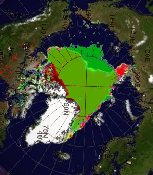
Barring a huge change in the weather, the map below shows the minimum possible extent for 2012 vs. 2007
Green is 2012 and red is 2007. This is based on current ice thickness and temperature forecasts. Chances are that 2012 will finish larger than what I showed, because there is a lot of MYI in the Chukchi Sea which is not likely to melt out.
The only thing which could change this would be very strong southerly winds, like those which occurred in late summer 2007.


“The only thing which could change this would be very strong southerly winds, like those which occurred in late summer 2007.”
Or data tampering…
We have satellite images. There really isn’t any way for people to tamper with data.
As part of my lengthy college career, I was a Remote Sensing major. All one has to do is redefine ice categories, and voila! An artifact is born!
Kind of like what Muller did with station quality categories, in his WORST study.
That’s what PhotoShop is for. Would they stoop that low? maybe….
The only explanation I have for 2007 is, PDO shift that slowed down the Gulf Stearn and North Atlantic Current, which allowed Arctic ice more summer sun exposure.
Anybody else with consistent explanation, let’s hear it
2007 was primarily a wind driven event.
Combination, since England noted a a strong Gulf Stream reduction that year
Gulf Stream sorry
The forecast models indicate pools of unusually cold air rotating around the Arctic Basin for the next couple of weeks. That should limit the amount of melt quite a bit. After that, the season is basically over. If Hansen tries to claim August is much above normal in that region, that would be yet another smoking gun about his dishonesty.
He will. I guarantee it.
Meanwhile the Arctic rowers are stuck at 2 miles south of Barrow, Alaska, about 100 feet from shore because of the incoming sea ice.
http://www.arcticrow.com/2012/08/04/a-tough-spot/
You can read on https://www.facebook.com/arcticrow
Large sheets of ice are swiftly moving into Barrow, exposing the team to a dangerous pinch against coast
Team is backtracking to take cover. Incoming storm is a rare event in strength – even for the Arctic.
Once safe, team could be iced in for up to 10 days before ice retreats.