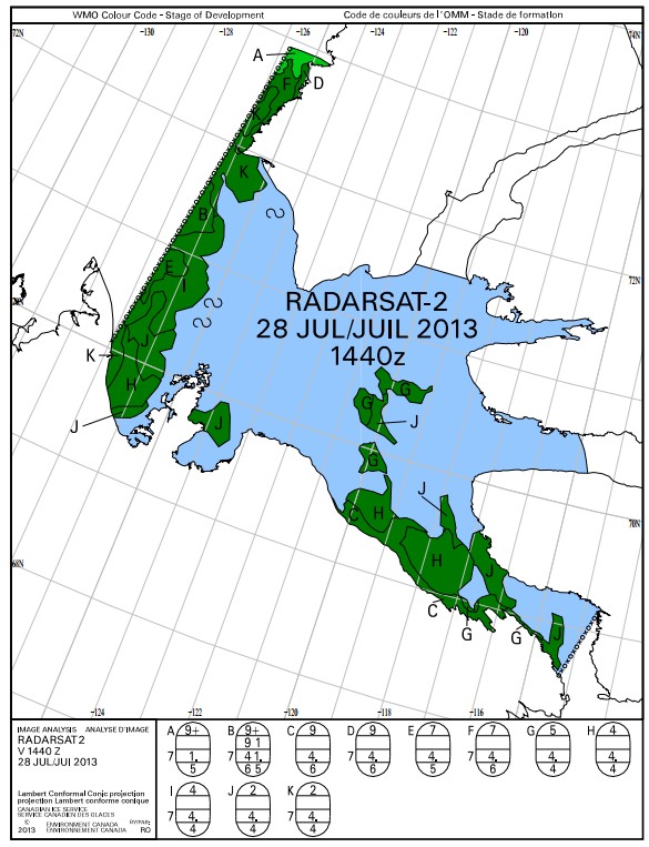
The rowers have been obscured by clouds for several days, but radar from two days ago shows how close the Beaufort Sea ice was to Cape Parry on Sunday. It is undoubtedly much closer to the rower’s tiny island now, where they are stuck in a storm.
It is dangerous to listen to greedy people who are looking to make money off your suicide mission.
ice-glaces.ec.gc.ca/prods/WIS139SD/20130728144000_WIS139SD_0007183404.pdf


What are the green bits, Steve?
ice!
What are the white bits then??!!
land!
One more silly question then!!
The ice is graded A, B, C etc. It appears A is the thickest/most concentrated.
Do we know what the scale is?
http://www.ec.gc.ca/glaces-ice/default.asp?lang=En&n=84F6AA59-1&wsdoc=FE5C2688-21A8-4165-8FFB-5D28B2A1D943
Translation of ‘J’ areas – 2 tenths coverage – thick first year ice – medium floes
Given that “egg” scale, then they folks generating those maps don’t worry much about those itty bitty ice floes of a size that parked on the rowers’ anchor.
Yet our Darwin Award wannabes are cruising around in a boat that can’t shrug-off the medium ice floes (100-400meters) of thick first year ice (4. = > 1 meter thick) Which just happen to lie between them and Paulatuk.
And 20% concentration doesn’t mean much if they get caught between 2 of the medium chunks of “slushy rotten first year ice” that just happens to mass 5000-125000 tons (lots of math assumptions with tapering edges, etc) (metric tons or English tons, who cares, it’s a lot of mass with which to make a pancake outta a row boat)
Hell that boat is in trouble arguing with “Ice cake” of the 2-20 meter class floes.
Since the Brawndo Blowhard Blowtorch was an Arctic no-show, the boys should declare victory and pack it in.
When their satellite SPOT tracker comes back on, they’ll be heading up the southern coastline, no doubt-:)
Looks like they might reasonable weather tomorrow, then it goes downhill again, with strengthening winds, turning easterly by the weekend.
http://www.wunderground.com/cgi-bin/findweather/hdfForecast?query=cape+parry
Just wait till they get some heavy rain, which they seem to have avoided so far.
I was wondering why they didn’t make a beeline to Paulatuk.
That collection of ice on the downwind side of the peninsula is only going to get larger and thicker. and the big wall is approaching at about a mile an hour.
They’re well and truly… Erm… Stuck is a polite word I suppose.
I think its too rough for them, even with the wind behind.
Pet your earlier question . . .
The Egg Code
http://www.ec.gc.ca/glaces-ice/default.asp?lang=En&n=7901F1A0-1
Doesn’t translate easily.
The egg code …. tabernac.
Our.
Colin de binne la!
You know Al Gore is tracking them on Satellite pictures not that tracker that turns on and off. Hedge funds use real-time zoom in satellite pictures to track certain business to see if they are busy. Spies in the sky.
Maybe you can get some one to pull some up.
Solid white east of Bernard Harbour. Ice field?
Solid white (not land) = no data
Thx.
These thrill seeking grandstand era asked for it. I was always told to be careful want you ask for, because you just might get it.
I’m rooting for Karma.
“Grandstanders”, not “grandstand era”. Damned iPhone.