
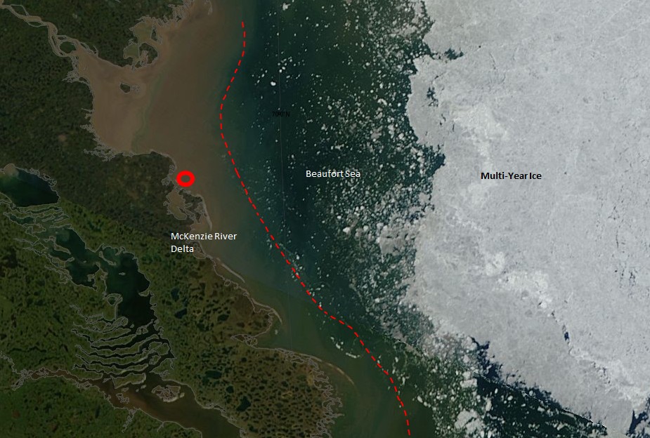
Red circle is the boat’s location. (We still haven’t seen any pictures of them actually rowing the boat.)
Left (south) of the red dashed line is dominantly muddy freshwater in the McKenzie River delta.
Right (north) of the red dashed line is Beaufort Sea saltwater.
Large bright ice mass on the right is multi-year ice, which is being pushed by the wind towards the coast. The image was taken three days ago. The ice is closer to shore now, but is obscured by clouds.

At their current rate of progress, they’ll have to return for several summers to finish their “trek”.
Maybe they aren’t drinking enough “Brawndo”. It has electrolytes!!!
They’re booking now at about 2 mph.
Actually, there is a picture of the boat coming into Tukyoyatuck. It was snapped by a local and posted on their facebook page.
Regardless of he salinity of the water, they are rowing briskly, having reported good progress around 11:10.
It does seem, however that the rate of progress may not be sufficient to get them to Pond Inlet, ice or no ice. Especially since the winds bother them, and winds can get very strong in the arctic, as your the Greenland adventurers found out last month.
“rowing”
Do you think they are using their blowtorch for propulsion?
I believe that picture was posted by their Sponsor….. so, not exactly a “local” who happened to see them.
Reblogged this on Climate Ponderings.
Looks like they are headed to shore. Back toward the brown water.
The “shore” is river sediment accumulated in the delta.
It seems they’re up to about 15 knots. Did they hitch a ride?
Probably!
Technically, that is Fluvial Geomorphology. Always appreciated a good Meandering Thalweg.
I spent time up there on DEW Line stations (PIN Sector) and the ice can be so far offshore you can’t see it and the next morning the low tide beach will be covered in huge ice walls and jumbles.
All about the wind now.
Not only now, the ice extent is more about movement and packing than temperature.
Blowtorch Driven Climate Change (BDCC)
http://www.psmsl.org/data/obtaining/stations/1000.php
Better get the life jackets ready.
Seriously, if you don’t think they are rowing, how do you think they are moving? There doesn’t seem to be outboard motor and no sail.
They may have a kite sail.
Maybe they are being towed by a 510hp Seadoo 230
Snark/off
Reggie:
That is entirely possible!
If they had some other means of propulsion, they wouldn’t get stuck so often.
Check out this photo from the Facebook page of Henry Stccn, the Inuit gentleman who posted the picture of the rowers coming ashore at Tuk.
The first photo is of his awesome 510hp Seadoo 230 kicking butt in the Beaufort during the Canada Day holiday weekend. That was the time when the “torch” visited Tuk, notice the lack of Ice?
https://www.facebook.com/photo.php?fbid=10153023055265002&set=pb.567015001.-2207520000.1373752767.&type=3&theater
https://www.facebook.com/photo.php?fbid=10153023051230002&set=pb.567015001.-2207520000.1373752768.&type=3&theater
Why would there be ice in the McKenzie River Delta in July?
Are you a complete moron?
Here is some Advanced Glacial Geomorphology 402 for you…..
Pingo Canadian Landmark is in the geological structure called the Beaufort-Mackenzie Basin. For at least the last 100 million years, this area has received sediments from the Richardson Mountains and other more or less extinct landforms around the Mackenzie River. The bedrock in the Tuktoyaktuk area formed from these sediments and is made up of both sandstone and shale. The youngest bedrock is the so-called Beaufort Formation, which contains a range of material from gravel-sized particles to clay.
Above the bedrock lie thick deposits of sand, capped by mixed sediments left by the last glacial advance. The sands form two layers. The lower layer is a grey, well-sorted, medium-grained deposit – called the Kidluit Formation – which was probably deposited in a broad alluvial plain. Above these Kidluit sands is a brown, fine-grained layer called the Kittigazuit Formation. This formation is thought to be the deposits of a large delta, but also includes sand that was blown around in the cold, dry climate leading up to the last glaciation. These sands are exposed at Peninsula Point, where Kilutqusiaq Pingo has been cut and eroded by the ocean. They also underlie the massive icy beds found in the area.
Above the sand layers is mixed sediment, called glacial till, which is a direct remnant of the last ice sheet to cover the region. The massive ice at Peninsula Point formed between the Kittigazuit sands and the glacial till. The top of the massive ice lies between one and ten metres below the ground surface.
http://www.pc.gc.ca/eng/docs/v-g/pingo/index.aspx
It look’s like Garmin maps are wrong too, you should inform them that they are mistaken.
https://www.facebook.com/photo.php?fbid=10152812156750002&set=pb.567015001.-2207520000.1373752827.&type=3&theater
BTW, I did take advanced glacial geomorphology back in 1977 and aced it.
ROFLMAO – so a small peak sticking barely above the McKenzie river delta changes what?
Steve, do you realize how ignorant you appear to individuals who are not into your fact free “faith based” science?
Who pays you to make post this crap?
Anyone who has taken a freshman class in geology knows what a river delta looks like, except for obviously you.
You spread garbage propaganda for pay. I counter it for free, as a labor of love.
So Steve, in your alternative reality, Garmin, Google and Park’s Canada are all wrong, but you are right.
What propaganda do I spread?
They aren’t wrong. You just don’t have any idea what we are talking about.
Steve, that is projection on IMAX scale.
Their track, shown on http://mainstreamlastfirst.com/, shows them skipping Tuk.
Their GPS gracker evidently was turned off while they were hunkering down in the Pingo’s. There are photos of them in Tuk.
And after rowing in a triangle and going backwards, they have evidently decided to call it quits for the day.
Why would a local need a boat like that if the ice never thaws there?
For that matter, why is it called the NW Passage if it is not passable?
Looks like the rowers are having trouble with wind again. They just sailed in a triangle and ended up back of where they started.
Care to explain to me how the river formed 150 high pingos?
http://stevengoddard.wordpress.com/2013/07/13/rowers-route-blocked-with-ice/
So you can’t give an explanation how a river 25 km away can form 150 foot tall pingos, which aren’t even fluvial in origin.
facepalm
Has the possibility occurred to either of you that the definition of where a bay ends and a sea or an ocean begins might be entirely arbitrary rather than scientific or objective??
In any event, it is certainly the case that they are much more exposed to sea-like conditions now than they were when they left Tuk, and Steven this merits recognition, regardless of whether they are in the Beaufort Sea right now.
At the same time, Reggie, your attempt to prove Steven wrong about his definition of the outer boundary of an estuary or river is strange, because your effort depends exclusively on the nature of surrounding landforms, and ignores the conditions of the water (e.g. waves, current, depth, distance to land in all directions, tidal effects) which in my view would be central to any acceptable definition, even an arbitrary one.
Notice I did not mention salinity because I don’t consider that to be central to the question, which is ultimately about the proper boundary between a bay and a sea, and the presence or absence of a river draining into the bay is irrelevant to this. This is a question of boating conditions and at what point the conditions warrant recognition that a boundary has been crossed from a bay into a sea. And the fact that there is a river and fresh water in the vicinity is irrelevant to the question of where the bay ends and the sea begins. (As irrelevant as are the nature of the surrounding landforms!)
RTF
Is that some more of your “faith based science”?
http://richardtfowler.wordpress.com/
Richard T. Fowler Offering Christian and Christ-centered commentary about climate- and energy-related issues
Reggie, thanks for that non sequitur answer.
This is a useful demo of how sophists of this ilk always try to get in the last word even when it’s completely irrelevant to the subject being discussed. In other words the idea is to score points – if not by winning the argument, then by casting aspersions.
How does BrawnDo mutilate thirst? How’s the company doing? Do they pay minimum wage? Are they an equal opportunity employer? Do they reduce their corporate tax with the Irish Double or with the Dutch Sandwich?
It’s a logical deduction, as are your thoughts. Both are subjective. As a wise person named Andrew once stated at Curry’s blog, any actual science departed this scene a long time ago.
RTF
Bravo.