
The wind is too much and the rowers have apparently quit trying to reach land. They are headed out to open sea with a strong tail wind, poor visibility, no anchor and possible ice. Where will they end up?
The wind is too much and the rowers have apparently quit trying to reach land. They are headed out to open sea with a strong tail wind, poor visibility, no anchor and possible ice. Where will they end up?

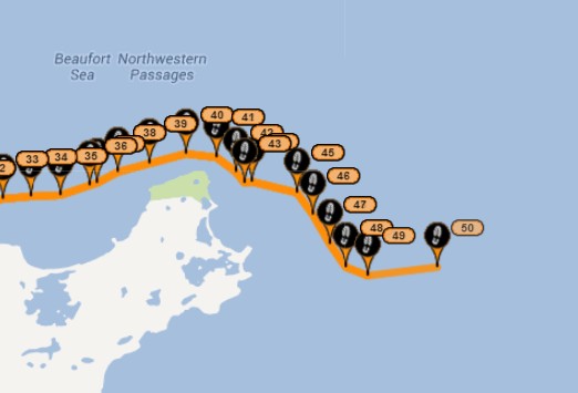
There is a small “Gilligan’s Island” ahead on the satellite.
They are headed for the beach.
Wahoo! 15 miles today – a big one.
That area is also known for polar bears.
Big ones. Google Cape Parry.
Polar Bears are extinct. American SUVs drowned them.
http://en.wikipedia.org/wiki/Cape_Parry
They probably need a permit to land there, it’s a protected area.
Is there a “Stand Your Ground” law in Canada against polar bears?
They’re not rowing – they’ve tied themselves to an iceberg, and letting it pull them along.
Either that, or they’ve thrown the GPS overboard, and letting it drift.
From the July 29 post “The Smoking Hills Of Franklin Bay”:
“There’s significant ice throughout the bay and our only choice is to travel south, deeply into it, until we find and adequately safe point to cross.”
Going to be a long trip if they’re hugging the coast, but have to constantly look for safe shore areas to park and rest.
Check out Tom Nelson’s page. Mainstream first-to-be-last posted a picture of their boat caught in the ice, on Facebook. Tom took a screenshot of it- the picture appears to no longer be there.
The picture is in the latest on http://mainstreamlastfirst.com/
It’s also in their flickr photostream.
http://www.flickr.com/photos/95019072@N08/9391527356/
Grab yer copies of those photos now. Like Change.org, history will be scrubbed so that the believers may continue to believe. (Change.org scrubbed most of it’s content since they removed all the broken Oh-Bomb-Ya promises from their site. Especially the one about the Oh-Blame-Ya administration pledging to protecti whistleblowers It’s Snowden’s fault you see…..)
http://mainstreamlastfirst.com/wp-content/uploads/2013/07/Paul-in-ice-small.jpg
http://mainstreamlastfirst.com/wp-content/uploads/2013/07/Chsi-de-Berg-small.jpg
(Can’t quite figure out how to post images, though likely Steve doesn’t allow it)
Missed this one.
http://mainstreamlastfirst.com/wp-content/uploads/2013/07/dragging-Franklin-Bay-small.jpg
A photo of the primary propulsion system (feet & rope) with Growlers all around….
I figured as much a long time ago…they would find the shore line where the ice had melted and pull it along….however, that is only good for a while.