
The animation below shows why the Canadian Archipelago rowers have delayed their launch. On their advertised start date of July 1 the route was completely impassable. They have had a lucky break though, and between July 1 and July 4 southerly winds blew the ice 30 miles to the north, opening up a little bit of room for them.

One minor quibble with the photo you posted
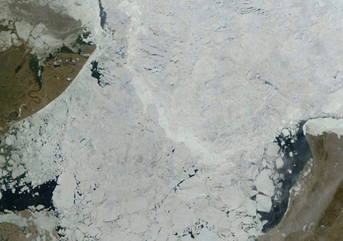
It isn’t anywhere near the mouth of the McKenzie River were the rowers hit the Beaufort sea. Your pic is showings Banks Island which is about ten days into the row.
August 9th is the ass kicker date, Reggie!
@Reggie wrote:
It took them more than ten days to reach even a third of the distance to Banks Island. At fifteen days in, they’re still not much more than a third that distance.
I’ve got the spreadsheet on my site: I’m predicting arrival at Pond Inlet (at their rate so far) of November 28 or so. A bit tricky, considering that impassable ice that will have set in many weeks before.
Of course, westerly winds are likely at some stage.
Care to wager on their likely completion this year?
===|==============/ Keith DeHavelle
Here is something you may find interesting, the ice in the waters around their destination has melted out already, a full month before it did last year.
Remember the +90F temperatures at Kugluktuk last week? The ice in the bay has melted and there is now a huge algae bloom.
What does their destination point have to do with the bulk of the voyage?
http://www.ijis.iarc.uaf.edu/cgi-bin/seaice-monitor.cgi
Also, search 2012 on the same date…
I have a much better way of looking at ice conditions that allows you to compare day to day and year to year.
http://earthdata.nasa.gov/labs/worldview/?map=-45110.286291,-48690.54186,322505.713709,138957.45814&products=baselayers,MODIS_Aqua_CorrectedReflectance_Bands721~overlays,arctic_graticule_3413&time=2013-07-4&switch=arctic
Go to the route of the row, magnify it to the highest setting and observe the ice.
Compare that to what was there a mere week ago. Then compare it to last year
You can argue until you are blue in the face, but that isn’t going to change the reality of the situation.
Looks nice:
http://www.esrl.noaa.gov/psd/map/images/fnl/sfctmp_01.fnl.html
You bet it looks nice, it couldn’t look better for an open NW Passage
. The SST around the NW corner of Baffin Island ( the destination)are already near 4C. This area was still frozen solid last year.
I believe the NW passage was declared open last year on July 28. This year it will be open at least a week earlier.
August 9th!!!
Here a link for the SST.
http://www.esrl.noaa.gov/psd/map/images/fnl/sfctmp_01.fnl.html
http://www7320.nrlssc.navy.mil/hycomARC/navo/arcticsstnowcast.gif
Correction: Here a link for the SST.
Too many tabs open
Are they not rowing down a small channel in the McKenzie delta … that appears to be what their location sez?
http://mainstreamlastfirst.com/?slide=home
That link just takes you to the main page and then u need to go into news to find the locator / progress map or trip tracker.
Re: Mackenzie spelling.
I fooked up when I assumed Reggie had a brain …. I want to spell it Mac but noticed Reggie spelled it Mc and assumed he had it correct … not …. Mackenzie is correct – “mac” and a small “k”. You can learn something everyday 😉
OMG!
I made a spelling mistake, therefore everything I have written is completely wrong.
I am curious, did you bother to take the time to click my link and actually look at the present ice conditions?
Nope to ur link but I went elsewhere for the same but what does that have to do with anything? I made no comments on ice conditions only on the rowers position and spelling!
In a couple days, high pressure will be bringing in North to East winds over this area. That’ll bring the ice back into the shoreline along with cooler temps.
It’s a trap!
Chewage: What is the significance of August 9th?
Looks like about 1 MPH the last day or so.
http://mainstreamlastfirst.com/?slide=home