
They are 50 miles away from 40% concentration ice. Red circle shows their location. Blue circle shows the ice.
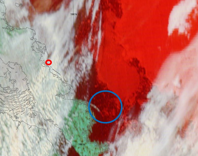
This ice has blown in during the last three days. Compare with July 10 below
If the current winds continue, their route will be completely impassable in about three days.

The “Blowtorch” tm will get there first! 😉 Just ask Reggie!
Maybe the rowing team need a “boobsled” just like these intrepid kite surfers.
http://www.cairns.com.au/article/2013/07/14/245254_local-news.html
They would probably do better with that than what they have.
The organizers have promised inflatible dinghies and bear repellant spray for the next team of morons who make the attempt.
They will be eating their dead any day now!
The Polar Bears will take care of that! No Worry!
Polar bears won’t eat road kill.
OH yeah! They do, just like any other bear. They are hunters of opportunity. If they do not clean up the remains other critters will.
I smacked an 8′ Brown Bear after my son woke me up at 2:45AM (AK Time) this morning after he completely destroyed our garbage dumpster, and I never need to worry about the bears until late August – through September, so we’re wondering if the bears know something about the upcoming seasonal change that we don’t:)
Summer is really going to be short this year.
I understand they are mapping the coast for a real estate developer, Brawndo Developments. Apparently lots of people from Arizona will be moving up there to escape the heat. They get a free blowtorch with every block purchased.
Boy! Now you tell me about the Blowtorches! I bought twenty blocks last week, before they were offering the “Torches”. 🙁
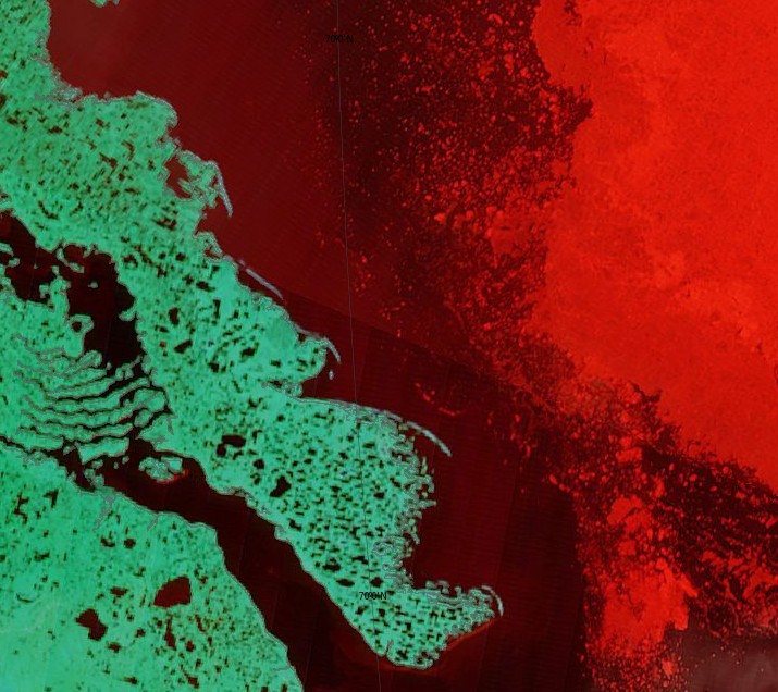
The Modis Aqua satellite view has a few less clouds that than Terra and gives a clearer view.
http://earthdata.nasa.gov/labs/worldview/?map=-2355680,-292689.856351,-2015200,-98129.856351&products=baselayers,MODIS_Aqua_CorrectedReflectance_Bands721~overlays,arctic_coastlines_3413,arctic_graticule_3413&time=2013-07-13&switch=arctic
That certainly isn’t 40 percent concentration in your circled area when viewed with 721 correction, According to Ice Canada, the compacted ice off shore is 40 percent concentration and first year ice.
The marine forecast calls for north west winds at 20 knots tomorrow and north winds at 15 knots on Monday.
The rowers will have to decide whether or not to proceed on Monday, if they get that far. There is only one more potential blockage in their immediate path, unfortunately neither satellite got a peek of it today.There is a third one more than 7 good days of rowing away, after that it will be clear for several weeks.
One thing about the weather: even the best (save perhaps Piers Corbin) cannot predict that far ahead. Not even three days, accurately.
If a “GOOD DAY” of rowing is two steps forward and three steps back, they should make their starting point by mid August. They should arrive, again, in TUK tomorrow.
🙂
Reggie:
You should really go back to school and learn about River Deltas! I learned about them in the 60s. You are still making yourself look foolish!
Please give me an explanation how a river 25 km away can form 150 foot tall pingos, which aren’t even fluvial in origin.
facepalm
Reggie:
You are the only one talking about the pingos. Everyone else is talking about the river delta that is and was created by the river carrying mud into the ocean and dropping it where the water stops moving as it meets the ocean. It could be deposited a hundred miles away and it would still be part of the river delta. You might want to rethink your claim the pingos are not fluvial in origin. some thing had to deposit the material they are composed of, unless they are Basalt or remnants of volcanic activity, which I seriously doubt.
A gift:
pingo [?p??g??]
n pl -gos
(Earth Sciences / Physical Geography) a mound of earth or gravel formed through pressure from a layer of water trapped between newly frozen ice and underlying permafrost in Arctic regions
BTW: You are in need of a “FacePalm” for your display of ignorance!
Are you that dense?
Here is some Advanced Glacial Geomorphology 402 for you…..
Pingo Canadian Landmark is in the geological structure called the Beaufort-Mackenzie Basin. For at least the last 100 million years, this area has received sediments from the Richardson Mountains and other more or less extinct landforms around the Mackenzie River. The bedrock in the Tuktoyaktuk area formed from these sediments and is made up of both sandstone and shale. The youngest bedrock is the so-called Beaufort Formation, which contains a range of material from gravel-sized particles to clay.
Above the bedrock lie thick deposits of sand, capped by mixed sediments left by the last glacial advance. The sands form two layers. The lower layer is a grey, well-sorted, medium-grained deposit – called the Kidluit Formation – which was probably deposited in a broad alluvial plain. Above these Kidluit sands is a brown, fine-grained layer called the Kittigazuit Formation. This formation is thought to be the deposits of a large delta, but also includes sand that was blown around in the cold, dry climate leading up to the last glaciation. These sands are exposed at Peninsula Point, where Kilutqusiaq Pingo has been cut and eroded by the ocean. They also underlie the massive icy beds found in the area.
Above the sand layers is mixed sediment, called glacial till, which is a direct remnant of the last ice sheet to cover the region. The massive ice at Peninsula Point formed between the Kittigazuit sands and the glacial till. The top of the massive ice lies between one and ten metres below the ground surface.
http://www.pc.gc.ca/eng/docs/v-g/pingo/index.aspx
It look’s like Garmin maps are wrong too, you should inform them that they are mistaken.
https://www.facebook.com/photo.php?fbid=10152812156750002&set=pb.567015001.-2207520000.1373752827.&type=3&theater
BTW, I did take advanced glacial geomorphology back in 1977 and aced it.
To show I am a really nice guy that thinks you should learn of what you are speaking:
http://en.wikipedia.org/wiki/River_delta
http://en.wikipedia.org/wiki/Fluvial
Reggie:
Did you read what you wrote:
“this area has received sediments from the Richardson Mountains and other more or less extinct landforms around the Mackenzie River. The bedrock in the Tuktoyaktuk area formed from these sediments and is made up of both sandstone and shale. The youngest bedrock is the so-called Beaufort Formation, which contains a range of material from gravel-sized particles to clay.”
The Material was “DEPOSITED” The area is a fluvial deposit and ice cones pressed up the material to form the pingos.
miked, you are right out of the movie Idiocracy
Did you miss this in my post?
“Above the sand layers is mixed sediment, called glacial till, which is a direct remnant of the last ice sheet to cover the region”.
and this….
“This formation is thought to be the deposits of a large delta, but also includes sand that was blown around in the cold, dry climate leading up to the last glaciation.”
What part of, “leading up to the last glaciation”, don’t you understand?
That means the top layers were formed from materials that are not fluvial in origin and were deposited before the Mckenzie was even formed.. The fluvial deposits which predate the last period of glaciation are under the glacial till , thus ruling out being part of a current delta.
Learn to read complete sentences!
You are too dense to waste keystrokes on, ciao.
Reggie:
Where do you think the sand originated from. It does not matter what the name of the river was or even if it was laid down by a glacier. It is still considered fluvial as it is the result of erosion of the mountains that formed the water shed for that region.
Getting back to the post, currently the rowers are travelling though the muddy waters that originated from the river. That means they are still travelling through the river delta. When they reach salt water they will be in the ocean, but they will have left the muddy water behind.
BTW, I specifically made reference to the deposits being part of a large “DELTA”! NUMBNUTS! What is part of the current delta is the mud and sand washing into the sea at this time!
The super fast rowing sings a different tune:)
http://www.youtube.com/watch?v=7otAJa3jui8
It’s global weirding, Reg. Freakish CAGW/CC winds are blowing the ice around.
Reggie:
You should sue the school that taught that class, because you did not learn Squat!
Correction:
DIDDLEY SQUAT!
Delta:
http://en.wikipedia.org/wiki/Ganges_Delta
http://en.wikipedia.org/wiki/Yukon%E2%80%93Kuskokwim_Delta
And
http://en.wikipedia.org/wiki/Mackenzie_River
40% and climbing as they head east.
40+% means moving back and forth while navigating the bergs without a clear view ahead.
The amount of iceberg action will make the next 5 days quite miserable…
Icebergs come from from glaciers.
The ice the rowers are facing is first year ice less than a foot thick, so if 90 percent of it is below water, that only leaves a bit more than an inch above water. How is that going to block their view?
http://www7320.nrlssc.navy.mil/hycomARC/navo/arcticictnnowcast.gif
I live near Lake Huron in Michigan. It isn’t uncommon for the wind to pile up ice 6-8 feet high into huge walls. If you’re not careful after a fresh snow or during a snowstorm, they blend in with the background and snowmobiles/ATV’s crash into them. Does that occur in the Arctic? I don’t know, but that’s what it does on the lake here.
The Titanic could care less:)
Ant the delta of the river I live 500′ above is quite the number in fluvial deposit:
https://en.wikipedia.org/wiki/Copper_River_(Alaska)
I know all about glacial silt and have for a long time:)
Chewer:
But of course you would!
It is also just possible you might have seen what ice does as it is moved around by wind.
We should not expect such from Reggie. In his world ice is flat no matter what!
In Reggie’s world ice does not do this:
http://www.youtube.com/watch?v=fqptbtwXUCs
At that latitude, cold water mirage.
This occurs also out in the lake off shore, but not as high and the ice is not as broken up, at least in my experience: The thinner ice is broken up and pushed on top of the thicker stronger ice and form “walls”. You can’t see a thing past them.
http://news.bbc.co.uk/2/hi/americas/7934598.stm
Team Twisted have some really bad news in their future…
Their planned trip was not planned very well and if they’re relying on knowledge and experience from like minded individuals like Reggie, they should seek retribution when they get out of the living nightmare they’ve set out on…
On “Deadliest Catch” The “Wizard” makes its way thru thickening ice to harbor….and gets stuck.
Now, imagine this feat (even in less ice concentration) but with only human power for your craft.
http://www.youtube.com/watch?v=UlhFEzmmSlM
A row boat should be able to get through that with no problem!
Here is some evidence of what wind does to ice along the shore. Of course it is only “Thin” first year ice:
http://io9.com/freak-ice-tsunami-crunches-homes-in-canada-504411441
Figure rowing again. A nearly perfect triangle. 9.8 point.
Excellent thread.
A solid 8.75 on the RBEI.
Reggie Blowtorch Entertainment Index.
Because beclowning himself is a self inflicted wound,
They turned off their tracker after their retreat yesterday. They will either be at Pond inlet tomorrow or TUK. Depending on whether they hitched a ride with an ice breaker or got another tow.