
By 1975, scientists had figured out that UHI was warming temperatures by 2-4 degrees
Science News, Vol. 107
March 1, 1975Already man-made climate changes are clearly evident around cities. Buildings and pavement tend to store more heat than vegetation in the surrounding countryside, hence temperatures can range some 4.0 degrees higher in the summer and 2.0 degrees higher in the winter.
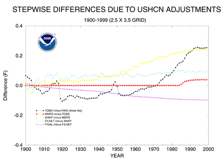
The NOAA UHI adjustment for 1975 is -0.09 degrees, less than 3% of the actual effect.

I don’t understand. I see nothing in the chart labeled “UHI.”
Final minus Filnet is the UHI adjustment.
So the ClimAsrologists are saying the Urban HEAT Island Effect COOLS the temperature by 0.1 degree so they have to ADD an additional 0.1 degree to the temperature readings.
Is this because of ‘the New Math’ they are using ?
https://www.youtube.com/watch?v=DfCJgC2zezw
Interesting…. the effect is small, but before 1910 the coal burning, urban areas were actually slightly cooler than the undeveloped rural sites. Or so they impute.
Probably due to the haze from particulate matter in the air. If the particles SOx and NOx got into the upper atmosphere it could block some incoming sunlight . Also particulate matter could act as nuclei for rain formation.
Doesn’t even have to be the SOx/NOx getting into the upper atmosphere to do it. The lower level, nearly constant smoke cloud will do some cooling all by itself…just like any other cloud cover.
The oxides would probably be a more ‘global’ effect and the smoke clouds would be more localized. Combined, they could very well be akin to putting SPF 45 sunscreen on the planet.
They didn’t have the massive amounts of concrete and tarmac paving we’ve got now. There was much more vegetation in cities so those probably lowered the UHI by a little bit.
Yes Neil but they also had all that fermenting Horse Manure in the streets. (We just have it fermenting in DC)
The Great Horse-Manure Crisis of 1894
(That should be required reading for everyone before they are allowed to vote. Test for comprehension mandatory.)
Okay, but burning organics is burning organics and the last time I checked, burning wood or dung was ‘smokier’ than coal, simply because coal had a lot of the volatiles ‘boiled off’. Am I misremembering (yes, I’ve seen the coal fired steam locomotive pictures …)?
In the late 1800s/early 1900s, especially in Europe (UK, in particular) a lot of the coal used by industry (other than iron working/smelting) and home heating was often the lower grades or even lignite (barely solid peat). That stuff is very smoky. The better stuff was reserved for trains, metal work and commercial power generation. It wasn’t very often that something like anthracite was available for ‘mundane’ uses.
Anthracite is much more volatile and hazardous to store and transport than Bituminous because of the dust. I have worked in the coal systems at a couple dozen different electrical generating units and another 8 or 10 places like cement plants and lime plants where coal fired their rotary kilns. All of them, even those in N. Dakota and near Las Vegas used bituminous. There are a few that use anthracite but not that many it seems.
I grew up in the anthracite region of NE PA. It burns nice and clean. But it seems that it was used close to the source, especially for power generation…in fact there are/were a couple of power plants that basically were built at the mines. So it came out of the ground and was used, no storage/shipping needed.
Okay. I don’t remember anyone using lignite around my neck of the woods, so I was misremembering. Re dust: well sure, the dust could be hazardous, just like fine sawdust or cotton dust.
See note below from NOAA site: Then go to link below for Steve McIntyres response to the study done by Tom Peterson.
NOAA 03-107
FOR IMMEDIATE RELEASE
Contact: John Leslie
9/15/03
NOAA News Releases 2003
NOAA Home Page
NOAA Public Affairs
NOAA STUDY OFFERS NEW TAKE ON URBAN HEAT ISLAND EFFECT
A new National Oceanic and Atmospheric Administration (NOAA) study of temperatures in America’s rural and city areas has prompted some scientists to reassess their understanding of the “Urban Island Heat” effect. The analysis, conducted by NOAA’s National Climatic Data Center (NCDC) in Asheville, N.C., indicates the temperatures of urban areas when compared to nearby rural locations are about the same. The analysis will be published in the latest issue of The Journal Of Climate. NOAA is an agency in the Department of Commerce.
The term Urban Heat Island refers to the well-documented fact that cities – with more buildings and roads and less grass and trees – are warmer than nearby rural areas.
Thomas C. Peterson, a climate expert at NCDC, conducted the study based on information from 289 rural and urban weather stations throughout the nation. He said the major difference in his analysis from previous urban heat studies is that he considered other factors that could influence the temperature observations.
Once NCDC adjusted the data to account for all other factors that cause differences in temperature readings, from the time of day the temperatures were recorded to the elevation of the station, differences between the rural and urban temperatures we examined were very small.
“This is not to say that Urban Heat Islands do not exist. Major highway intersections and industrial centers of cities may well be significantly warmer than rural areas,” said Peterson. But weather stations are more likely to be located in parks than industrial areas and other research has indicated that urban parks can be significantly cooler than the industrial parts of towns.”
Peterson also noted, “Rural sites are not necessarily pristine. Land use changes around rural sites – whether it is the growth of trees or the paving of driveways – can also impact temperature observations.”
NOAA’s Satellite and Information Service is the nation’s primary source of space-based meteorological and climate data. It operates the nation’s environmental satellites, which are used for weather and ocean observation and forecasting, climate monitoring and other environmental applications, including sea-surface temperature, fire detection and ozone monitoring. NOAA’s commercial licensing program draws on NOAA’s heritage in satellite operations and remote sensing applications.
The Satellite and Information Service also operates three data centers, which house global databases in climatology, oceanography, solid Earth geophysics, marine geology and geophysics, solar-terrestrial physics and paleoclimatology.
NOAA is dedicated to enhancing economic security and national safety through the prediction and research of weather and climate-related events and providing environmental stewardship of America’s coastal and marine resources.
On the Web:
NOAA: http://www.noaa.gov
NOAA Satellites and Information: http://www.nesdis.noaa.gov
National Climatic Data Center: http://www.ncdc.noaa.gov
I’ve written here before about the work Steve McIntyre did to debunk the study by Tom Peterson. This study is the reason NOAA does not make any UHI adjustments. If they did, CAGW would not be a topic of discussion any more.
Go to this link to read what Steve McIntyre did. Beautiful piece of work.
http://climateaudit.org/2007/08/04/1859/
Thanks for the pointer.