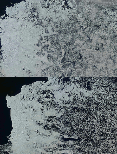
The blink comparator above shows the changes in the ice in the Beaufort Sea between August 15 and August 18, 2010. You can see several things happening.
- The ice is being blown to the north (right) by the wind.
- A lot of the thinner ice (on the right side) is melting out.
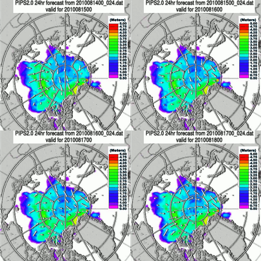
The blink comparator below shows the PIPS ice movement during that same period. You can see the strong winds pushing the ice edge.
So what is melting the thin ice in the top image? Warm winds blowing off North America and Siberia.


For years you have been telling us that when the air is at 0 deg C, the air can’t melt the ice. Then you try to explain that although too cold to melt the ice, the cold dry air can cause the sublimation of the ice.
Now you seem to have come up with the idea that convective heat transfer from the air is the major source of heat melting the ice again.
Please consider the idea, that the sea water under the ice melts the ice. The sea water under the ice can melt ice at temperatures down to -2 deg C due to salt assisted melting. The sea water carries thermal energy into the Arctic from the Atlantic and Bering Strait year round, and in the summer, absorbed solar radiation adds additional thermal energy to the sea water. The sea water carries the thermal energy under the ice pack, and melts the ice from below.
When the ice pack begins to fracture and break up, the melt rate increases since the sea water has more contact area to melt the ice floes from the sides, as well as from below. The pictures in this post, show the heavily fractured ice floes in the thin ice section of the Beaufort being washed by sea water.
At the edges of the ice pack, there is wave action due to the fractured ice; so in one sense, you have this correct. Wind does cause more ice melt, but not due to strong increasing melt from above, but due to wave action that increases convective heat gain from the sea water around the ice floes.
In the winter, the air temperatures drop dramatically, so instead of just a few degrees C difference between wind temperature and the ice, we see 30 to 40 deg C difference or more. Then heat transfer FROM the ice to the air makes sense. But in the summer, the amount of heat that is transferred from wind at 0 to 5 deg C, INTO the ice, isn’t significant compared to the heat transferred into the ice from sea water.
Mr. Goddard, please think this through… Your ideas aren’t holding together well.
[Reply : There are a number of problems with your statements, but I don’t want to discuss theory here. Note that the ice melted very quickly between August 15 and August 18. It is unlikely that there was much change in the water temperature during that period. The reason it melted was wind. I live near a large lake which completely melted out during two windy days in late March this year.]
Were the waves on your lake higher when the wind blew? Was the temperature of the air blowing over the ice higher than 32 deg F? If the wind is 50-60 deg F and is blowing across the ice, then surely the wind can melt the ice. But when the wind temperature is only around 32 deg F, then the melting due to thermal energy transferred into the ice from the air (wind) is unlikely. The main effect of a cold wind on ice melt, is the wave action that increases the convective heat transport of thermal energy from the water in the lake to the ice.
Funny, this is what you have been saying for years on the blogs; that cold freezing air can’t cause significant ice melt, and now you claim that cold winds are the primary source of ice melt in the Arctic. Think about it; please think about it.
There were no waves on the lake, because it was covered with ice. The air was around 40F, similar to the wind temperature coming off Alaska or Siberia in August.
Remember that the ice melt in the images above is at lower latitudes, and is 1000 miles from the pole.
The more I read this, and think about this, I believe you are saying that there were warm winds blowing over the Arctic this August, and thus the surface air temperatures in the Arctic were much higher than normal. Is this what you are claiming? And these warmer air temperatures coupled with the wind, melted the ice?
So I guess you now agree with the Hansen/GISS temperature record that claims there is significant warming of air temperatures across the Arctic? That no longer are summer air temperatures near 32 deg F (on average), but are 10-15 deg F higher (on average) and even higher during certain warm wind events?
Wow, this is a major shift for you, Mr. Goddard.
Hmmm, a thousand miles from the pole… I see a lot of open water intruding into the ice pack above the 80N parallel this year. And in today’s Bremen Polar View of Arctic ice pack, I see open water polynyas above the 85N latitude around the 150E to 195E longitudes.
I guess the ice melts in these areas due to warm winds as well? Does this mean the Arctic has air temperatures over 40 deg F with “warm winds” in these areas?
This is even more confirmation that GISS is correctly extrapolating higher surface air temperatures across the ice cap.
Zinfan,
You need to remember that the Arctic Basin is a very large place.
I have been writing about DMI/GISS discrepancies north of 80N. The ice in these photographs is much further from the pole. It is normal to have warm winds coming off the land masses. By the time they get to 80N, they have cooled to near the freezing point.
Zinfan
Leads open up near the pole due to shear and tensile stress. They usually has nothing to do with melt.
Ok… got that. But when I look at today’s Bremen ice map, I see a polynya in the ice pack at about 87N and 165W that looks pretty large. The diameter of the opening in the ice, is roughly the same as the distance across the Cook Inlet outside of Anchorage, or approximately 50 miles across.
Can you explain how shear and tensile stress can open up a 50 mile “hole” with less than 15% ice area, surrounded by fractured ice floes with less than 25% area coverage for another 50 miles or so in some directions. How do you get such enormous stresses when the surrounding ice is fractured and apparently melted out down well below 25% in area? And this is only a few hundred miles from the North Pole! Clearly somehow the ice melted in this area. How did the thermal energy reach this area?
If your theory is correct, then warm winds well over 40 deg F have reached all the way to the 87N latitude in late August, in order to melt out the ice pack in this area in the last several weeks. Somehow thermal energy had to get to this area, to melt over several hundred square kilometers of ice pack down to less than 25% coverage, with most of the area less than 15% coverage. And to get this far north, the warm winds had to traverse over hundreds of miles of ice pack. You have quite a theory going… it is a bit hard to believe.
The warm winds of August, and now September, must be moving an enormous amount of thermal energy over the ice pack this fall… I mean based on your “air and wind temperature driven melt” model. I am not convinced that the ice pack isn’t melting primarily because of sea water currents under the ice pack moving thermal energy to the ice. Are you sure that my hypothesis is wrong?
zinfan,
Please look at the historical photos of the pole
http://stevengoddard.wordpress.com/2010/09/03/north-pole-then-and-now/
I have seen that photo. The opening the subs are in doesn’t appear to be 50 miles across… but even the fairly big openings the subs are in were likely due to ice melt in addition to ice stress fractures.
You don’t have a photo like that in say, March or April, for example? That is the season when ice stress should be large. A photo like that would support your theory nicely.
I still can’t calculate thermal energy transport from air to the ice that will melt the ice as fast as observed in the real world. I still stand by my analysis that indicates that sea water is the major source of thermal energy to the ice pack and drives the ice melt through most of the season. Only for about 5-6 weeks in late June and July are air temperatures really high enough to add a significant amount of thermal energy to the ice pack.
Zinfan,
Look closer. The second sub photo was taken in March.