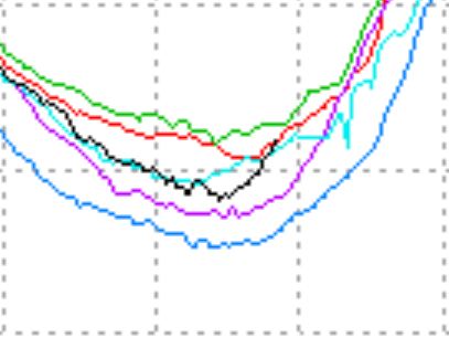
DMI now shows 30% concentration ice ahead of 2005 and 2009. There has been about 20% growth over the last two weeks.
Some years like 2005 (red) had essentially no growth during the same period. What happened this year is that the late ice “loss” starting in mid-August (which made our friends on the other side so happy) left a lot of cold water behind that refroze easily – once the wind stopped and the temperatures dropped below freezing.
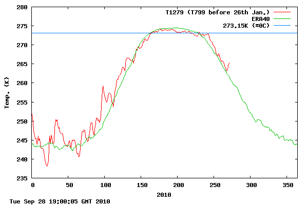
Note the the heat released from the freezing ice is now showing up as a spike in the DMI temperature graph.


Pingback: Arctic Continues Record Ice Growth | Global Warming Skeptics
And the latest update from JAXA shows an increase in ice extent of 105K km² from 27 to 28 Sep. Lots of Margarita’s to party with (or scotch on the rocks, if you prefer).
refroze easily – once the wind stopped and the temperatures dropped below freezing
Wile E. Coyote came flying out of the stretched power lines. 😉
Posted this on WUWT, and will post here too…
Another massive gain yesterday. CT area showed an increase of 108842 km^2. Since the minimum, we’ve gained 624214 km^2, now the highest gain from the minimum in the last 10 years! Remember that there were plenty of years 1979-2000 with bigger increases though.
JAXA extent was also impressive, with a gain of 105157 km^2 yesterday. This makes 2010 the first year in the JAXA record with more than one 100000+ km^2 single-day gains in Sept. And the gain is steady – in the last 4 days, we’ve set the 3rd, 4th, and 5th largest single-day gains in the JAXA Sept record. We still have two more days left in Sept too. 🙂
Earlier I’d said I expected us to be within 100000 km^2 of 2009’s extent by the month’s end and that we would pass it on Oct 3 (and pass area by Oct 5). The gain has been much faster than I expected, and we may pass both in Sept, though I think Oct 1-2 is a more likely possibility. We’re 101628 km^2 behind in area, and only 50937 km^2 back in extent.
The real question is whether these rapid gains have much meaning…
-Scott
I wonder if we will see record ice gains in October as we did in 2008.I would think that if it freezes early it will get thicker by next summer.
Scott Said
The real question is whether these rapid gains have much meaning…
Er no
Check out area,
http://arctic.atmos.uiuc.edu/cryosphere/IMAGES/seaice.recent.antarctic.png
Slight gain.
Wind can effect extent on the way up as on the way down 😉
Andy
Andy,
Please read my original post again. I was talking about area as early as the third sentence. The CT area is showing very large gains too. Since their respective minima, CT area gain has been 624214 km^2 (20.3%) and JAXA extent gain has been 659844 km^2 (13.7%). Those numbers look pretty comparable to me and suggest to me that these gains are not dispersion-driven. Yesterday, for instance, showed a large area gain than extent gain. If you have evidence suggesting my conclusions are in error, I’d be happy to consider it.
The link you provided was for the Southern Hemisphere, which I assume was unintentional. A lot of people bring up the SH ice, particularly the skeptics. I’ve never discussed SH sea ice before and profess that I have essentially zero knowledge on the subject. Thus I avoid the topic, and because it does not seem to be the chosen battleground, I likely won’t be getting up to speed on it anytime soon. If someone could point me to a link with area and/or extent numbers (not graphs) for the SH, I’d show a lot more interest.
Again, my real question isn’t whether a large refreeze is happening fast (as indicated by both area and extent), it’s whether those refreezes mean anything. I haven’t had the time to go looking for trends/correlations yet…
-Scott
Oops sorry Scott, yep you are right.
So you are not Scott of the Antarctic then ? Sorry, couldn’t resist.
Andy
PS I expect gains to decrease as the warm SST’s start to make an impact.
Andy
Preliminary JAXA extent is less positive than it has been the past few days. Every value has been revised upward as of late, several in the 40000 km^2 range. However, even a revision of 30000 km^2 will only get us up to average extent gain for Sept 29.
So maybe this is a sign that you’re right, or maybe it’s just a one-day slowdown. I don’t follow the SST’s or weather up there really, just the numbers and CT’s maps/animations.
-Scott
Extent is back to where it was when the wind started blowing in August. That region of cold water is again consumed by ice, so it should follow a more normal path from here on out.
Posted this on WUWT, but doesn’t seem to be much conversation there, so I’ll re-post here:
JAXA extent slowed yesterday, with the lowest extent gain in over a week (57481 km^2). That low value is right at the average in the JAXA record (just a touch lower, actually). That leaves it with the 2nd greatest growth in the JAXA record since the minimum, 54532 km^2 lower than 2002 (which had its minimum 9 days earlier). However, 2002 performed relatively poorly on Sept 30, so with a gain of about 80000 km^2, this year would end up with the best extent increase from the minimum to Sept 30 in the JAXA record. The average gain over the last 8 days is about 77k, so I think we’ve got a 50% shot or higher at reaching this. Passing 2009 by Sept 30 is a different story though. It’d require roughly 109k of increase, so its probability is probably 5% or less.
CT’s area measure, on the other hand, had a day that would make any polar bear beam. Gain was 135524 km^2, beating the average by about 50k. Area gains since the minimum are now blowing away anything in the last 10 years. Oh, and we passed 2009. 🙂 Unfortunately, I don’t have my area spreadsheet as detailed (yet) as my extent spreadsheet, otherwise I’d give you some additional figures.
Hmm, given the massive area gains yesterday, maybe I should raise my probabilities for extent performance on Sept 30…
-Scott