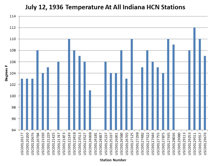
Every reporting station in Indiana recorded temperatures over 100F in Indiana on July 12, 1936. Five Indiana stations made it to 110F, and it was 112F at Wheatfield, Indiana. The forecast high today in Wheatfield is 82F, thirty degrees cooler than the same date in 1936.
CO2 was below 320 PPM at the time. Hansen says that recent heatwaves (much cooler than 1936) were not possible below 350PPM.
The #1 rule for many leading climate scientists is to never let actual data interfere with their theory.


Reblogged this on The Firewall and commented:
That would convert to 87F with the progressive conversion function.
The Toronto heat-wave of 1936:
“In late June of 1936, a heat wave – generally considered to be the worst ever recorded on the continent – began in the North American Midwest. Over the next few weeks the heat spread to the northeast, reaching southern Ontario in early July. On July 8, steadily climbing temperatures reached 95° Fahrenheit, or 35° Celsius, at midday, rising to a record high of 104.5°F (40.3°C) in the late afternoon. Temperatures exceeded 103°F (39.5°C) the next two days, and remained in the high 90s through to the 14th, with the meteorological office reportedly recording temperatures as high as 140°F (60°C) in the sun.”
http://heritagetoronto.org/the-1936-heat-wave/
Today in Toronto, it was in the mid 70’s. So far, the summer has been humid and wet, but high temperatures have mostly been in the high 70’s to mid 80’s.
Yes, but you did have the most extreme rainfall in history last weekend! LOL
Thankfully I live far enough west of Toronto that we escaped the flooding 😉
How did these floods compare with the Hazel floods of 1954?