
Disrupting the Borg is expensive and time consuming!

Google Search
-
Recent Posts
- You Can’t Fool Mother Nature
- Cattle And The Climate
- One Atomic Bomb Per Hour
- New Video : Analyzing Oil And Gas
- Is Antarctica Melting?
- High Speed Analysis And Visualization
- El Nino To The Rescue?
- Fake News Update
- Growth Of Antarctic Sea Ice
- 65 Years Of Progress!
- El Nino To The Rescue?
- Worst March Drought On Record
- ChartGL Process Control Demo
- The Biggest Money Laundering Scam
- Drought In The Headwaters Of Lake Powell
- Unrealistic Expectations Of Water Availability
- Did Bill Gates Do This?
- Worst March Drought On Record In The US
- The Real Hockey Stick Graph
- Analyzing The Western Water Crisis
- Gaslighting 1924
- “Why Do You Resist?”
- Climate Attribution Model
- Fact Checking NASA
- Fact Checking Grok
Recent Comments
- conrad ziefle on You Can’t Fool Mother Nature
- Bob G on You Can’t Fool Mother Nature
- Gordon Vigurs on You Can’t Fool Mother Nature
- arn on Cattle And The Climate
- Bob G on Cattle And The Climate
- Robertvd on Cattle And The Climate
- Bob G on Cattle And The Climate
- Robertvd on Cattle And The Climate
- Billyjack on Cattle And The Climate
- Bob G on Cattle And The Climate
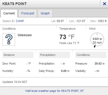
I Wonder If The 32 MPH Wind Is Affecting The Rowers?
This entry was posted in Uncategorized. Bookmark the permalink.
Hey, 73 degrees though on land. Since their position hasn’t been updated in a day, they’re probably getting tans. Every time the wind might blow them into deep water they get freaked.
Coming out of Paulatuk, though it isn’t a big bay, they write:
“This direct route to the far shore is shorter in distance than one more closely following the coastline but this direct route also exposes us to more risks. Travelling further out in the bay means water depths too deep for our ground anchor. If a wind starts pushing us where we don’t want to go we’ll be limited to our sea anchor to slow us down.”
“We make the difficult decision to head closer to shore, to take the longer coastal route in shallower water, so we can better control our movement. Our decision proves to be a good one as the next 24 hours has us deploying our ground anchor twice, both times to halt the aggressive push of a 20KN south easterly that would have blown us right out into the middle of Darnley Bay.”
There’s another massive Arctic cyclone brewing, so I don’t think the winds will ease anytime soon.
http://models.weatherbell.com/news/rgem_2013080712_dew2m_pole.gif
The reading says it is for Keats point, and I notice the elevation is near 1100 ft. So, possibly the wind is lighter on the water. But I also saw that Ryan Maui noted cyclone activity brewing…. wouldn’t wanna be there myself.
They’re on the move again!
Pop quiz!!! Can anyone see anything horribly wrong here?
http://mainstreamlastfirst.com/heading-into-paulatuk/
I wonder if he is the navigator…
The green tent that’s hard to see from a plane when pitched? THE LOADED SHOTGUN AIMED AT THE SLEEPING PERSON’S HEAD? The white boat that’s hard to see from a plane when amongst iceburgs ? The blue jackets that are hard to see from a plane if the wearer’s in the water?
What looks to be a gun is pointed toward his head.
I’m sort of glad now I cancelled my North West Passage kayaking adventure at the last minute.
So they turn the GPS off for 24 hours and move 5 KM in a 30 MPH cross wind. What did they do let the boat out on the anchor rope and walk along the shore?
The Arctic wading team laughs at wind!! They spit into it whilst dragging their boat through the northwest passage!! Wind is no obstacle to the Arctic wading team!!!