
NOAA snuck in a new tropical storm, just before the system made landfall.
AT 600 PM CDT…2300 UTC…THE CENTER OF TROPICAL STORM FERNAND WAS LOCATED NEAR LATITUDE 19.2 NORTH…LONGITUDE 95.8 WEST. FERNAND IS MOVING TOWARD THE WEST NEAR 9 MPH…15 KM/H. A WESTWARD TO WEST-NORTHWESTWARD MOTION WITH SOME DECREASE IN FORWARD SPEED IS EXPECTED OVER THE NEXT DAY OR SO. ON THE FORECAST TRACK…THE CENTER SHOULD CROSS THE COAST OF MEXICO IN THE WARNING
AREA BY EARLY MONDAY MORNING.REPORTS FROM AN AIR FORCE RESERVE RECONNAISSANCE AIRCRAFT INDICATE THAT MAXIMUM SUSTAINED WINDS HAVE INCREASED TO NEAR 45 MPH…75 KM/H…WITH HIGHER GUSTS. SOME ADDITIONAL STRENGTHENING IS POSSIBLE BEFORE FERNAND MAKES LANDFALL. WEAKENING WILL BEGIN AFTER THE
CENTER MOVES INLAND.TROPICAL-STORM-FORCE WINDS EXTEND OUTWARD UP TO 35 MILES…55 KM FROM THE CENTER.
Weather Street: Tropical Storm Fernand, Hurricane Fernand 2013
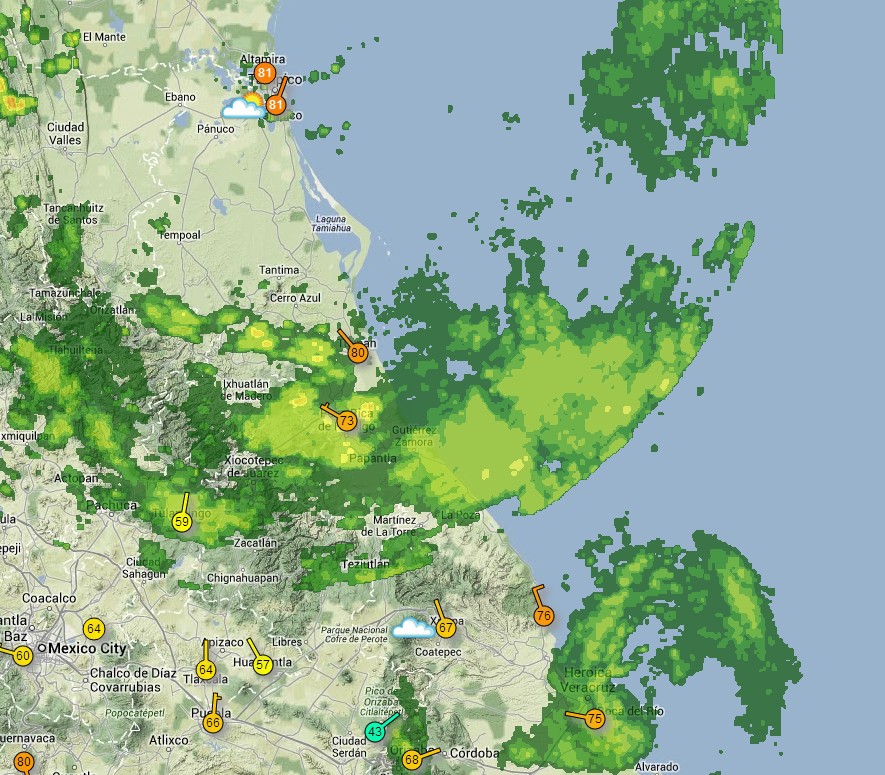
Weather Underground shows no winds over 10 MPH in the region.
WunderMap® | Interactive Weather Map and Radar | Weather Underground

Cloud naming…
Dorian and Erin certainly wouldn’t have been named from the 1970’s and earlier.
A case could very well be made for Fernand not being named as late as the 1980’s being the storm was basically a few hours from shore such that surface observation would have sufficed. Surface observations show what amounts to a gentle breeze.
Barry was a questionable tropical storm for six hours before making landfall and Chantal was basically a strong tropical wave, without ever having much of a circulation and zipped along at a rate where whatever poor circulation structure was there wasn’t able to maintain and it eventually degenerated. The only real storm to speak of was Andrea, which was your classic June sheared GOM tropical cyclone which fizzled as it hit the still cool waters in the northern Gulf before landfall.
In 1950 this season would have one tropical storm, Andrea, and zero hurricanes. 2013 we have six tropical storms.
Barry was a questionable president for two terms before voters put two and two together and came up with the realization that they’d been lied to.
Anyone using the criterion of “named storms” as a measure of tropical activity is living in a fantasy world. The naming of storms is highly subjective to put it mildly. There were tropical storms that hit Florida in 1965 and 1982 that had gusts measured up to hurricane force on land that were not named. Obviously, these pieces of BS do not deserve names.
That perfectly describes the current NHS and their parent organization the NWS and going up line to NOAA, ending at the Buck Stops at Skeeter!
Where does this one fit on the Weather Channel Scale (which replaced the Saffir-Simpson Scale)? Super storm? Monster storm? Gale Storm?
Super Exponential dangerous climate conditions!
Forgive me I failed to mention Unprecedented! That has to go in there somewhere.
LOL Gale Storm. Perhaps they could name this My Little Margie.
I have suspected all along that they were getting more and more desperate with naming storms that in past times weren’t named.
SEVERE WEATHER ALERT!!!
SUPERSTORM/HURRICANE ‘JET STREAM’ THREATENS PLANET!
Those assholes at NOAA are monitoring your site, Steve! I posted this in the ice post below, before they named those butterfly farts about to go ashore in Mexico.
It won’t be long before they announce that 2013 is a very active hurricane season, with more named storms than normal.
Your friend Dr. Masters has already said that on a number of occasions. These people are shameless. Look back in the historical record and see how many named storms have dissipated over the open ocean. You want unprecedented, this year’s storm season is it.
If a hurricane changes gender, so what started out named Bradley becomes Chelsea, does it count as one storm or two?
Three, since they get to adopt little Depressions to fulfill the empty space in their centers.
Good one! Manning up, eh.
You knew a day ago they were going to name this. This is a travesty. All you will hear about this season is that there have been seven named storms this year, above normal for the period. They are cowards, who play along in the AGW book. All that will be remembered from tis season is the above normal number of storms. See my post last week about losing the war. Here’s another example.
And in another universe:
http://forecast.weather.gov/showsigwx.php?warnzone=AKZ141&warncounty=AKC261&firewxzone=AKZ141&local_place1=12+Miles+NNE+Kenny+Lake+AK&product1=Special+Weather+Statement#.Uhq95kbTnIU