“Glaciers in the Himalaya are receding faster than in any other part of the world (see Table 10.9) and, if the present rate continues, the likelihood of them disappearing by the year 2035 and perhaps sooner is very high”
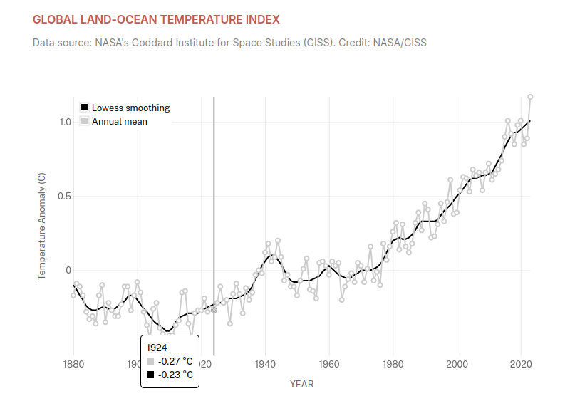
The world’s deadliest cyclone occurred in 1970 around the same time the New York Times and Washington Post were warning about “ominously” thickening Arctic ice and a new ice age.
“The world could be as little as 50 or 60 years away from a disastrous new ice age, a leading atmospheric scientist predicts. Dr. S. I. Rasool of the National Aeronautics and Space Administration and Columbia University says that.”
The National Park Service has a website showing glacial retreat in Glacier National Park since the early 20th century, but they forgot to mention that most of that retreat occurred before 1935.
“Sperry glacier in 1900 had a surface area of 840 acres. By 1938 the area had shrunk to 390 acres, and in 1946 to about 330 acres. Even more significant is the lowering of the glacier’s surface. In 1938 Sperry glacier had a thickness of 108 feet at the site of the 1946 ice margin. At this same place in 1913 the thickness was nearly 500 feet, and the average thickness of the glacier over the area from which it has since disappeared at least 300 feet. The average thickness of Grinnell glacier in 1937 at the site of the 1946 ice front was seventy-three feet. The surface of the entire glacier was lowered fifty-six feet during that 9-year period. This means that each year the glacier was reduced in volume by an amount ‘of ice equivalent to a cube 450 feet high. Thus the volume of Grinnell glacier was reduced by about one-third from September, 1937, to September, 1946.
One Is Almost Gone.
“Several other glaciers have exhibited more — phenomenal shrinkage than Sperry or Grinnell. The topographic map of Glacier National park. prepared in 1900-1902, shows several comparatively large glaciers such as Agassiz, Blackfoot and Harrison. Their shrinkage has been so pronounced that today Agassiz has virtually disappeared and the other two are pitifully small remnants”
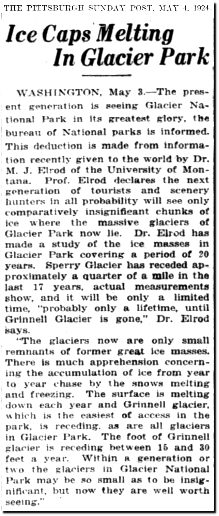
WASHINGTON, May 3.—The present generation is seeing Glacier National Park in its greatest glory, the. bureau of National parks is informed. This deduction is made from information recently given to the world by Dr. M. J. Elrod of the University of Mon-tana. Prof. Elrod declares the next generation of tourists and scenery hunters In all probability will see only comparatively insignificant chunks of ice where the massive glaciers of Glacier Park now lie. Dr. Elrod has made a study of the ice masses in. Glacier Park covering a period of 20. years. Sperry Glacier has receded approximately a quarter of a mile in the last 17 years, actual measurements show, and it will be only a limited time, “probably only a lifetime, until Grinnell Glacier is gone,” Dr. Elrod says.
“The glaciers now are only small remnants of former great ice masses. There is much apprehension concerning the accumulation of ice from year to year chase by the snows melting: and freezing. The surface is melting. down each year and Grinnell glacier, which is the easiest of access in the park, is receding. as are all glaciers in Glacier Park. The foot of Grinnell glacier is receding between 15 and 30 feet a year. Within a generation or two the glaciers in Glacier National Park may be so small as to be insignificant, but now they are well worth seeing.”
“Glacier Park Melting at a Rapid Rate in Scientist’s Opinion
CINCINNATI, Dec. 29.—(By the Associated Press)—The hot dry seasons of the past few years have caused rapid disintegration of glaciers in Glacier National park, Montana, professor W. G. Waterman of Northwestern university declared in an address today before the geological section of the American Association for the Advancement of Science.
Grerry glacier, studied by Professor Waterman, has lost one-quarter, or perhaps one-third of its ice in the past 18 years, he said. If this rapid retreat should continue, the professor added, the glacier would almost disappear in another 25 years”
Kamala Harris said Donald Trump’s Madison Square Garden’s rally was “filled with racist remarks.” Then Biden called Trump supporters “garbage” and Democrats tried to rewrite his remarks to say that the problem was just one person, which would be the nearly the opposite of “filled with.”
ChatGPT says that major hurricanes are caused by the burning of fossil fuels.
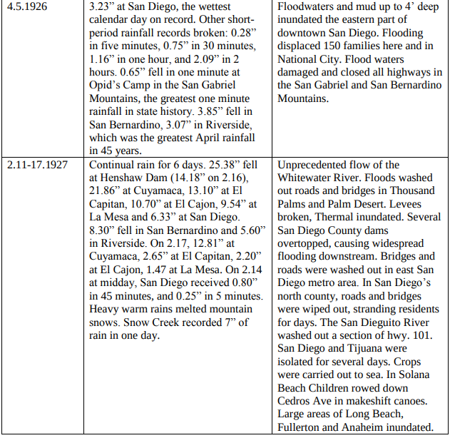
The Red Cross described fiscal year 1927 as the worst disaster year in their history including “29 tornadoes, 24 floods, 23 fires, 4 earthquakes, 9 hurricanes”
“Floods and Tornadoes Make 1927 Worst Disaster Year in Red Cross History”
By RODNEY DUTCHER (NEA Service Writer)
WASHINGTON, Nov. 25.— Mother Nature’s disposition to settle hostile, the year 1927 was the worst disaster year in American history, according to the Red Cross.
But the Mississippi floods seem insignificant compared to Mother Nature’s wildest rampages in 1927, and the recent floods in New England have added yet till of misfortune major disaster only second in its proportions to that of the Valley states.
Tornadoes and floods have killed more than 300 persons and inflicted property damage estimated at more than $1,000,000,000 since January.
Red Cross Kept Busy The Red Cross has never been so busy in its twenty-five years. Get within four months after it had finished its work in the Florida hurricane area it had to tackle its greatest relief task in its experience in seven states of the south and the middle west. It has aided nearly 700,000 victims of disasters.
Complete Red Cross records are only available up to the end of the last fiscal year ending June 30, 1927. During that fiscal year, the relief organization rendered aid in 111 disasters—a few of them outside the United States—which included 29 tornadoes, 24 floods, 23 fires, 4 earthquakes, 9 hurricanes, 6 mine disasters and some cloudbursts, explosions, railroad wrecks, typhoons and epidemics.”
September 30, 1927
“WOMEN MOTORISTS – Arctic and Australian Trips.”
“To drive by the light of the midnight sun, to race for life through forest fires caused by storm lightning, to lie for 15 hours at a time at the wheel, and to be caught in an endless heat wave and tormented by mosquitoes in what is known to us as the land of eternal snows, were among the recent experiences of an intrepid English woman, Mrs. Victor Bruce, who accompanied her husband and a companion in a 6000 motor tour through the Arctic zone.
Through Belgium, Holland, Germany, Denmark, Lapland, and Finland, the motor party journeyed to 270 miles north of the Arctic Circle, prepared for freezing weather. To their continued astonishment the temperature was never less than 90 degrees in the shade.
The intention was to reach the Arctic Ocean, but 40 miles of marsh country on the coast prevented this.
An average of 210 miles a day was made on the journey, which was arduous in the extreme, and at one time the car had an actual race with death among the forest fires in Sweden over terrible roads.”
The same weather in Spain as 1957 and 1897 is now caused by the burning of fossil fuels.
“51 dead in Spain due to catastrophic floods… Spain Not some far away place you can’t relate to Spain But sure, keep listening to politicians & shills bankrolled by the fossil fuel industry instead of people who dedicate their lives to understanding climate change.”
“50 Dead Possible In Spanish Flood
VALENCIA, Spain (AP)—The rain-swollen Turia River flooded the heart of this city Monday and drowned at least 18 persons.
City officials said they believed as many as 50 were lost.
Monday night the orange-growing Valencia area was a vast lake stretching five miles inland from the Mediterranean, with high ground and buildings forming islands crowded with survivors.
Helicopters were ordered from Madrid to help in the evacuation.
Not since 1897 had a comparable flood hit Valencia.”
“James Clapper says he misspoke, didn’t lie about NSA surveillance”
James Clapper, the director of national intelligence, said Thursday that he did not lie to them about government surveillance last year when denied the U.S. was collecting data on millions of Americans in a hearing last year.
“It has been very disappointing to have my integrity questioned because of a mistake,” Clapper told government officials and contractors at an intelligence summit in Washington sponsored by two major industry groups.”
“Clapper was one of 51 former intelligence officials who signed a letter in October 2020 claiming the Hunter Biden laptop story had “earmarks” of a Russian disinformation campaign”
“The 51 former US intelligence officials who smeared The Post’s bombshell reports on Hunter Biden’s laptop as “Russian disinformation” in a 2020 letter are standing by their decision — with some referring to the move as “patriotic” — even after the FBI and Justice Department have confirmed the device’s authenticity, according to a new report.”


