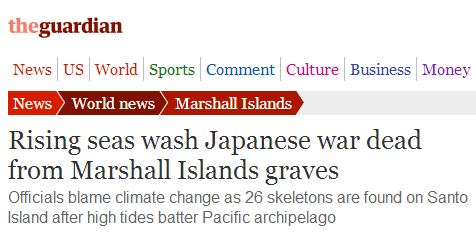
The Guardian says that rising sea levels due to global warming are washing away bodies in the Marshall Islands.
Rising seas wash Japanese war dead from Marshall Islands graves | World news | theguardian.com
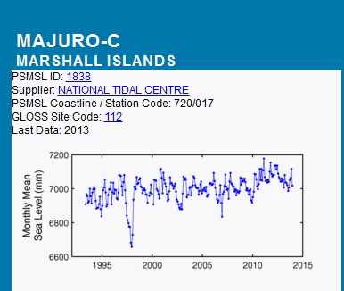
Sea level in the Marshall Islands is almost exactly the same as it was in 1997. As usual, the Guardian fails to do any fact checking.


Please note: There has been a sea level rise of 2 inches in the north Pacific since WWII.
http://tidesandcurrents.noaa.gov/sltrends/sltrends_station.shtml?stnid=1619910
2 inches is not enough to wash away very many corpses.
Correction. It went up by 6 inches since 1946 in the Marshall Islands.
http://tidesandcurrents.noaa.gov/sltrends/sltrends_station.shtml?stnid=1820000
6 inches of sea level rise is catastrophic, especially for dead people who can’t swim.
As best I can tell, there is no Santo Island.
Closest I can find is Santo, Vanuatu’s largest island and has the country’s four highest peaks (all more than 1700m) – Mt Tabwemasana, Mt Kotamtam, Mt Tawaloala and Santo Peak – rising from the mountainous spine that runs almost the full length of the island’s west coast.
Not that close…
Wrecks to Rainforest
http://www.wreckstorainforest.com/santo.html
“Only two and a half hours direct flight from Brisbane, less than 5 hours from Sydney (via Port Vila) or an hour by domestic flight from Port Vila, Espiritu Santo (link to Wikipedia), the largest island of Vanuatu (4,010 km2) was named by De Quiros(link to Wikipedia) in the 1606 when he made a navigational error of some thousands of miles in a vain attempt to find Australia.”
Espiritu Santo Island (Santo) Vanuatu (New Hebrides)
http://www.pacificwrecks.com/provinces/vanuatu_espiritu.html
Location – Espiritu Santo Island is the main Island in the New Hebridies (Vanuatu). To the south is Segond Channel and Aore Isaland. Also known as “Santo” or “Santos”.
.
No Santo Island listed:
http://en.wikipedia.org/wiki/List_of_islands_of_the_Marshall_Islands
Obtuse.
Your listing an island 1500 miles from the Marshalls is obtuse. We’re talking about the Marshall Islands, not Vanautu.
The wiki article is a bit sketchy. Kwajalein atoll (listed in wiki) comprises 97 islands – one of which is the one you are looking for – it is Ennubirr or Third Island. See my post below.
Is climate global warming change the cause of high tides now? this is idiotic!
Where did the Grauniad get the name ‘Santo Island’ from? What they are talking about is Ennubirr or Third Island as it is the third island in the chain south from Roi-Namur at the north end of the Kwajalein atoll. It has a population of around 6,000 on an island 1,300 ft x 800 ft (about 200 acres) – no wonder it’s sinking.
The health center there is called ‘Santo Dispensary’.
Maybe it’s tipping over?
LOL! In case anyone doesn’t recognize the reference, Billy is talking about this:
http://www.youtube.com/watch?v=v7XXVLKWd3Q
Is he stoned?
I don’t think he should be stoned. There are more traditional methods of punishment.
The real interesting thing about the graph is the dramatic FALLS in sea level between 1995 and 2000 WTF?
are
That’s the effect of the 1998 El Nino.
The geology of the Pacific Island is strange. The atols and islands have been well investigated over the years. From Hawii out to the Mashalls and beyond are volcanic outcrops. The Marshall Island are mainly coral limestone on a particularly thin part of the ocean bed. This coupled to overdevelopement with inappropiate building construction, and sea-walls built in the wrong places has lead to inundation and loss of habitable land.
None of the loss is due to CAGW climate change.
See reports by –
Haggerty, J.A., Premoli Silva, I., Rack, F., and McNutt, M.K. (Eds.), 1995
Proceedings of the Ocean Drilling Program, Scientific Results, Vol. 144
and
Journal Of Geophysical Research Volume 83, No. B3, March 10, 1978.
Island Subsidence, Hot Spots, and Lithospheric Thinning by Robert S. Detrick, MIT and Wood Hole Oceanographic Institution.
and
JOHNSTONE CENTRE OF PARKS, RECREATION AND HERITAGE REPORT No 23
‘GIFTS FROM THE WAVES’ A case of marine transport of obsidian to Nadikdik Atoll and the occurrence of other drift materials in the Marshall Islands.
Sorry I have not the links but they are all googleable (is that a real word?)
.
🙂
Meanwhile a piece on this topic in the UK’s Daily Telegraph notes
http://www.telegraph.co.uk/news/worldnews/australiaandthepacific/marshallislands/10883294/World-War-Two-skeletons-washed-from-Marshall-Islands-graves-by-rising-seas.html
When it comes to ‘global warming’ / ‘climate change’ The Guardian doesn’t care much about facts – it’s all about the screaming headline – that’s all that most will read and remember. For those that enter into the fray simply pad the article with climate propaganda, and Bobs yer uncle, job done.
Look, they were howling about how a warmer planet would kill all coral animals!
This is insanity since we know that the earth was far warmer in the past and especially eras when coral grew like maniacs. What kills coral growth is cold.
Here’s are NOAA’s graphs and regression analyses of sea-level at Majuro and Kwajalein, in the Marshall Islands:
http://tidesandcurrents.noaa.gov/sltrends/sltrends_global_station.shtml?stnid=720-017
http://tidesandcurrents.noaa.gov/sltrends/sltrends_station.shtml?stnid=1820000
Here’s Kiribati (eyeballing the map it looks like ~1000 miles to the east of the Marshall Islands):
http://tidesandcurrents.noaa.gov/sltrends/sltrends_global_station.shtml?stnid=750-012
Here’s Wake Island (~500 miles to the north of the Marshall Islands):
http://tidesandcurrents.noaa.gov/sltrends/sltrends_station.shtml?stnid=1890000
The best & longest Pacific Island sea-level record is the 109 year record at Honolulu (~1200 miles to the east-northeast of the Marshall Islands):
http://tidesandcurrents.noaa.gov/sltrends/sltrends_station.shtml?stnid=1612340
The best Western Pacific sea-level record of all is the 128 year record at Sydney, Australia (a few thousand miles to the south-southwest of the Marshall Islands):
http://tidesandcurrents.noaa.gov/sltrends/sltrends_global_station.shtml?stnid=680-140
New Zealand, Japan & Hong Kong also have pretty good long-term gauges:
http://tidesandcurrents.noaa.gov/sltrends/sltrends_global_station.shtml?stnid=690-002
http://tidesandcurrents.noaa.gov/sltrends/sltrends_global_station.shtml?stnid=647-023
http://tidesandcurrents.noaa.gov/sltrends/sltrends_global_station.shtml?stnid=642-091
http://tidesandcurrents.noaa.gov/sltrends/sltrends_global_station.shtml?stnid=611-010
Only one Pacific tide gauge has exhibited severe sea-level rise (but not due to CO2):
http://tidesandcurrents.noaa.gov/sltrends/sltrends_station.shtml?stnid=9455090
None of news media cared a bit when when whole bones and fragments of bone, almost certainly from dead Marines were found in abundance among the trash heaping up on the beach where the tide brought it in on Betio Island, Tarawa Atoll a few years ago.