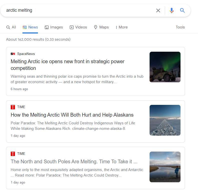
A Google news search for Arctic melting turns up 162,000 results.
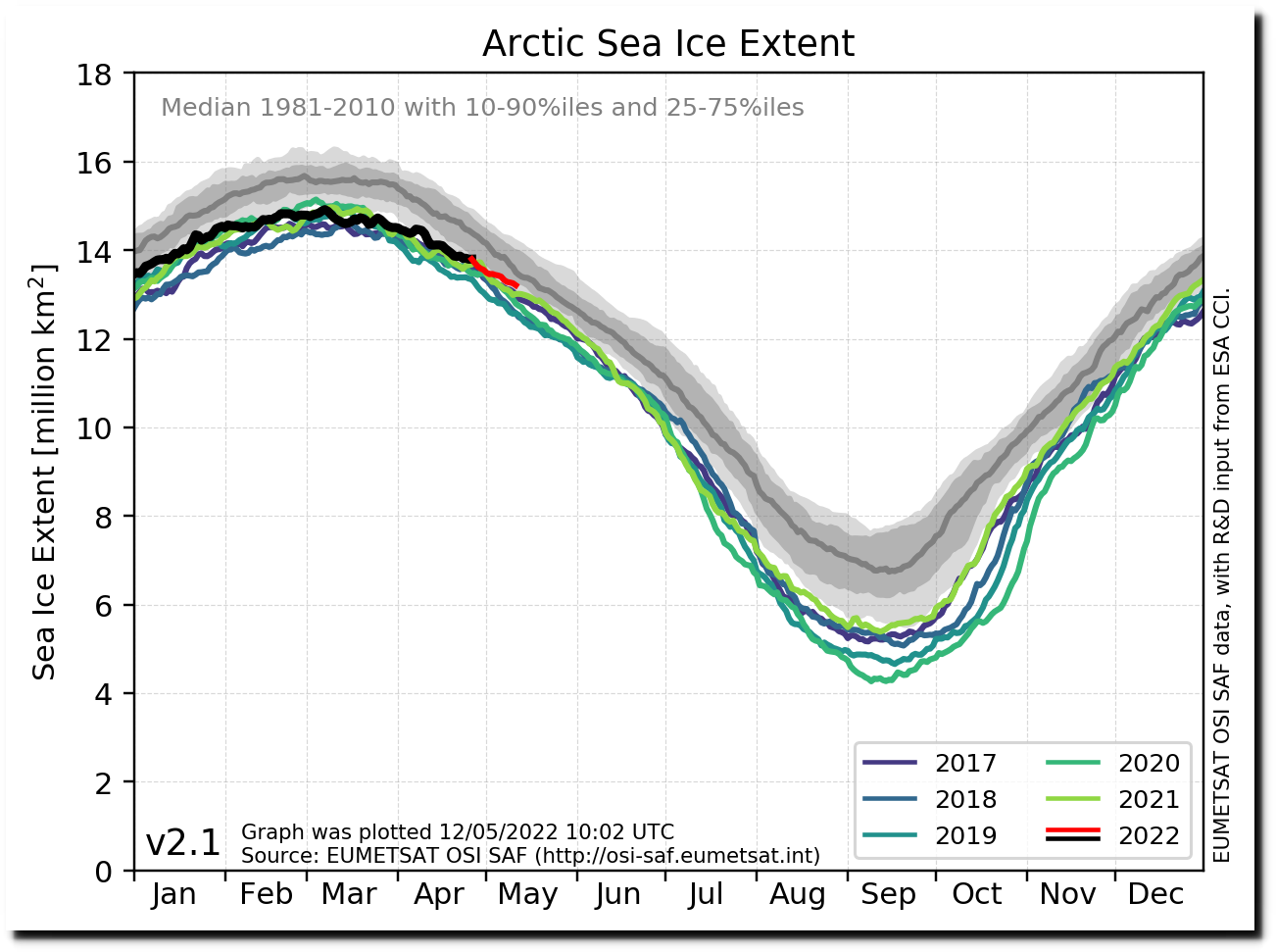
Arctic sea ice extent is just below the 1981-2010 median, higher than 1989 and about the same as 1996.
Ocean and Ice Services | Danmarks Meteorologiske Institut
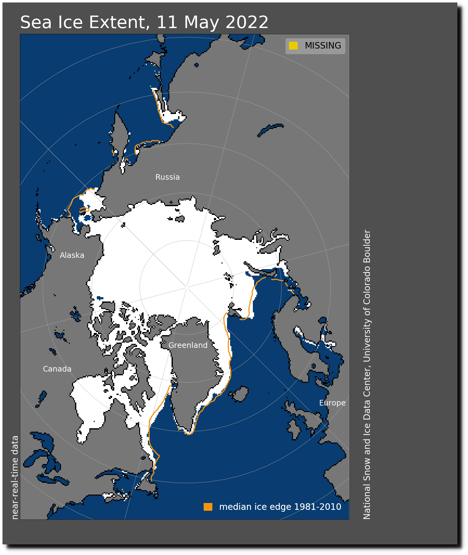
N_20220511_extn_hires_v3.0.png
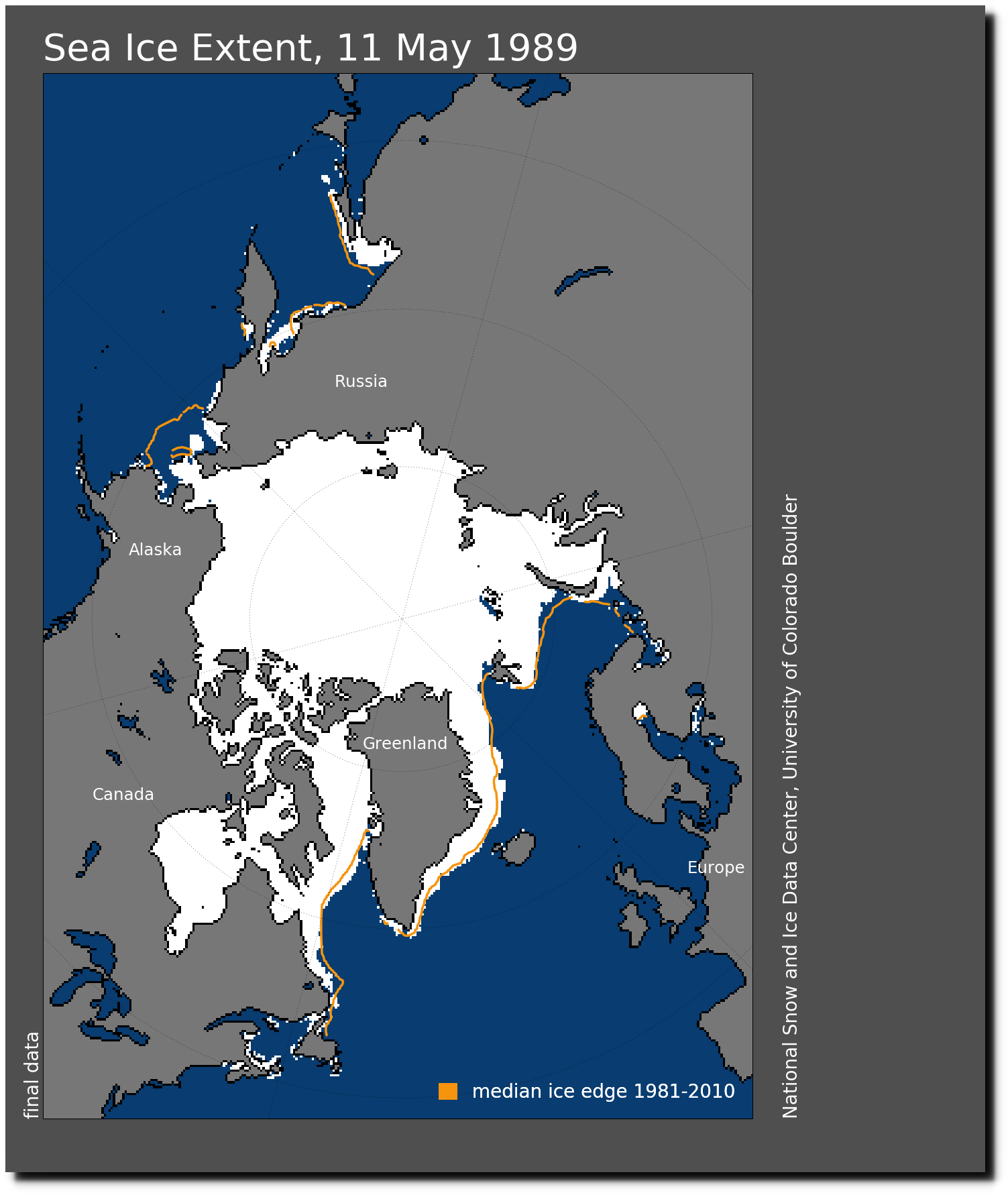
Let’s move NOAA headquarters to Alert,NWT.
Give us all a front row seat for the new beaches forming.
Maybe Carnival and Norwegian Cruise Lines can start up a Global Warming Escape Cruise in late August. Less chance for hurricanes.
Notice that their statements are put in the future. “How the melting Arctic WILL both HELP and HURT Alaskans” “Warming seas and thinning polar ice caps PROMISE TO TURN the Arctic…into a new hotspot for military… They are making the assumption that AGW is an established fact, so they can talk about what will happen when it comes to pass. This way they can never be accused of actually lying. We need to teach our young people to think critically – to analyze what they read and hear.
The Snow Water Equivalent in Alaska is amazing…
https://www.nrcs.usda.gov/wps/portal/wcc/home/quicklinks/imap#version=158&elements=&networks=!&states=!&basins=!&hucs=&minElevation=&maxElevation=&elementSelectType=any&activeOnly=true&activeForecastPointsOnly=false&hucLabels=false&hucIdLabels=false&hucParameterLabels=true&stationLabels=&overlays=&hucOverlays=state&basinOpacity=75&basinNoDataOpacity=25&basemapOpacity=100&maskOpacity=0&mode=data&openSections=dataElement,parameter,date,basin,options,elements,location,networks,overlays&controlsOpen=true&popup=&popupMulti=&popupBasin=&base=esriNgwm&displayType=basinstation&basinType=ak_8&dataElement=WTEQ&depth=-8¶meter=PCTMED&frequency=DAILY&duration=I&customDuration=&dayPart=E&monthPart=E&forecastPubDay=1&forecastExceedance=50&seqColor=1&divColor=7&scaleType=D&scaleMin=&scaleMax=&referencePeriodType=POR&referenceBegin=1991&referenceEnd=2020&minimumYears=20&hucAssociations=true&relativeDate=-1&lat=65.091&lon=-140.412&zoom=5.5
And?
And…what, Vegieman?
https://www.bing.com/videos/search?q=snowpack+alaska+records&qpvt=snowpack+alaska+records&FORM=VDRE
Water Year 2022
May 1st, 2022. (PDF 3.0MB) Snowpack across the state remains robust with only a few monitoring stations having melted out. In general, onset of melt-out was delayed a week due to a cool April and deep peak snowpacks.
April 1st, 2022. (PDF 3.0MB) More snow than you can shake a shovel at. Snowpack continues to be hardy across most of Alaska with scores of sites in the Copper, Tanana, and Yukon Basins setting April 1st and all-time record highs. Some of these records are sites that have 50 and 60-year histories.
March 1st, 2022. (PDF 3.0MB) The Interior keeps shoveling out as storms move the Tanana snowpack into record range. Much of the state copious amounts of snow, while a few limited areas fall shy of normal.
February 1st, 2022. (PDF 2.0MB) Midwinter finds snowpack across most of Alaska robust with only some smaller regional areas with below normal snowpack. Record storms in December in the middle of the state led to record or near record snowpacks in the Tanana, Yukon and Koyukuk
Snowpack at record levels in many parts of Yukon | CBC News
https://www.cbc.ca/news/canada/north/snowpack-record-levels-yukon-2022-1.6379106
Mar 9, 2022 … Record snowpack in parts of the Yukon is increasing the potential for flooding again this summer, but a government official says they won’t …
and…
ALASKA SPRING BREAKUP SUMMARY
NWS ALASKA PACIFIC RIVER FORECAST CENTER
ANCHORAGE AK
230 PM AKDT FRI MAY 13 2022
..RECENT NOTABLE EVENTS OR FORECAST CHANGES:
The main Yukon breakup front is at Koyukuk right now, and a watch
is in effect for that community as the ice downstream is stopped.
Ice is largely in place downstream of Nulato, although the local
ice in front of Emmonak melted out yesterday, 5/12.
..SPRING BREAKUP STATUS FOR ALASKA…
Statewide, breakup this year has been largely dynamic with ice jams
observed at McGrath, Sleetmute, Red Devil, Crooked Creek, Circle,
and Galena so far. While McGrath suffered major flooding, the other
ice jams created minor to moderate flooding because of the cooler
than normal temperatures this May.
The spring breakup flood potential for major rivers in Alaska:
..Middle and Upper Yukon River: Above average
..Lower Yukon River: Average
..Koyukuk River: Above average
..Upper Kuskokwim River: Above average
..Lower Kuskokwim River: Average
..Susitna River: Above average
..Tanana River and Chena River: Above average
..North Slope rivers: Average
..Copper Basin rivers: Average
This outlook is based on observed snowpack, ice thickness reports,
and seasonal temperature outlooks. It is important to remember that
while Alaska has experienced mostly mild winters for the past
decade, `average` is defined over a longer period. Average flood
potential may be higher than in recent memory.
…River Ice…
The two generalized types of river ice breakup are dynamic
(mechanical) and thermal. A dynamic breakup moves from headwaters
downstream in a somewhat linear fashion. Ice jam flooding occurs
more often during a dynamic breakup. A thermal breakup occurs when
the ice rots in place usually caused by a gradual warm up resulting
in very few and only minor ice jams.
April ice thickness data are available for a limited number of
observing sites in Alaska. Ice thickness is near normal across the
state. Cumulative freezing degree days (FDD), which can serve as an
indicator of ice thickness, are normal statewide from a marginally
colder than normal winter. FDD are 90 to 110% of normal for
Southcentral, the Interior, the North Slope, and the West Coast;
coastal locations around the Gulf of Alaska are 150 to 200% of
normal.
…Snowpack…
The May 1st NRCS Alaska snowpack analysis by the Natural Resources
Conservation Service (NRCS) indicated an above normal snowpack for
the majority of the state. Persistent average to below average
temperatures during the middle and late April delayed signficant
snow melt across the interior. Snowpack across the interior remains
well above average. The Kuskokwim basin has been omitted, as
it consists of only two data points, one of which has melted out.
May 1st Alaska Snowpack:
..Arctic: Near normal
..Upper Yukon Basin (largely in Canada): 210% of normal
..Central Yukon Basin: 190% of normal
..Tanana Basin: 320% of normal
..Koyukuk Basin: 120% of normal
..Lower Yukon Basin: 150% of normal
..Copper River Basin: 190% of normal
..Matanuska and Susitna basins: 180% of normal
..Kenai Basin: 130% of normal
…Climate Outlook…
Current weather models and NOAA`s Climate Prediction Center (CPC)
outlook for state through May 15th indicate higher probabilities for
below normal temperatures across mainland Alaska.
Source: https://www.weather.gov/aprfc/SRAK48PACR
– – –
https://www.weather.gov/aprfc/Snow_Depth
Denali has a 348″ reading of snow depth today at a base camp monitoring station , and a reading of 256″ at the 14,000 ft. camp
https://www.wcc.nrcs.usda.gov/ftpref/data/water/wcs/gis/maps/ak_swepctnormal_update.pdf
https://wcc.sc.egov.usda.gov/reports/UpdateReport.html;jsessionid=vAwg4Sq6pAmrWRKMZ88OhRF92AQ3CslWOcj4YcsS.nrcsprd0382?report=Alaska
Thank you! I am relieved to know that you weren’t telling us it was going to melt and deluge us. Interesting info. Seems to contradict the newsfeeds.