
“Experts say” that July was 2nd hottest on record and that autumn will be warmer than average in all fifty states

New forecast predicts an unusual fall season for nearly all 50 US states | Daily Mail Online
July afternoon temperatures were 55th warmest on record, and just about average since 1895.

The percent of days over 90F was below average and 46th lowest on record.

The mean daily temperature was 25th highest since 1895

NOAA massively tampered with the data to make July 10th warmest TAVG.
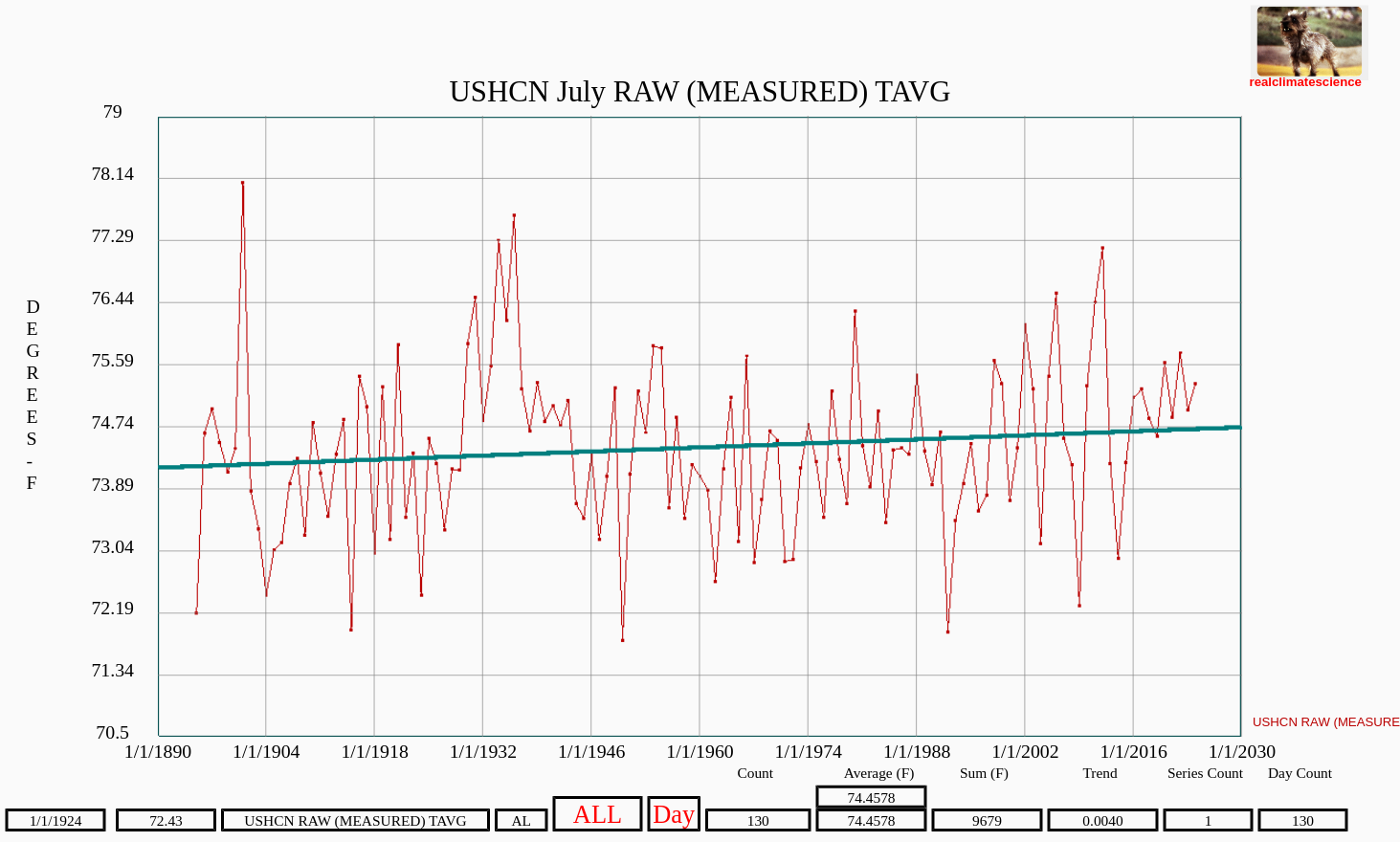
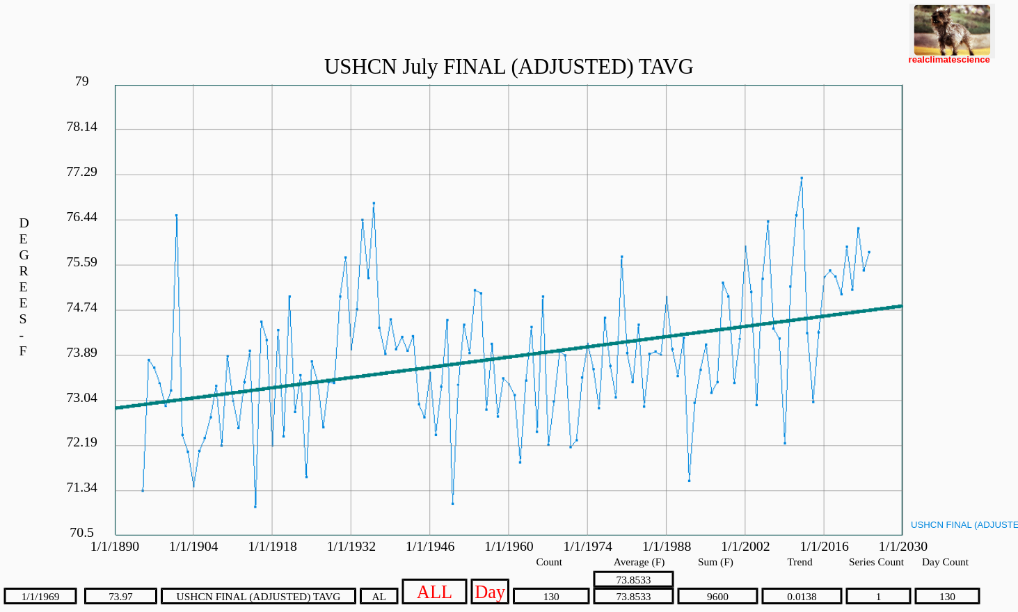


With more than two degrees of data tampering, it is quite likely that NOAA will claim a warm autumn across the US.
Half way through the month, Iowa is having one of their coolest Augusts on record, about four degrees below the 1895-2024 average.


‘Experts say there’s a high chance that nearly all 50 US states will see higher than usual temperatures this fall.’
‘Experts’ are paranormal people who can predict the future. 60 years ago, we laughed at such people. Now, they get big titles and government grants. And the press thinks they are real.
Mr Gamecock, note that the experts predicted that we would have up to 33 named storms in the Atlantic this season. oh my, batten down the hatches! so far we’ve had ONLY five. for some perspective, the wild year of 2005 that gave us hurricane Katrina, by mid-august that year we already had 10 name storms. so far we’re way behind the “experts” prediction
They don’t care that their predictions fail. It is all about the headlines. Cabal presstitutes never criticize the experts’ failed predictions. Those get buried underneath the newest dire predictions (which we know will also fail). And the beat goes on….
No, they don’t care. They generate hysterical headlines to push the emotional buttons of the masses. Stimulus/response. When their preposterous predictions fail to materialize they drop out of the news cycle to be replaced with another. I notice that they are trotting out Monkeypox (vaccine-induced shingles) again. Be afraid. The Cabal demands it
What does “named storms” even mean? They stick a name on every gust of wind above 25 MPH. Named storms means a whole lot of nothing. Katrina BTW was not particularly powerful when it made landfall, it had been significantly downgraded. According to reports at the time it struck New Orleans a “glancing blow”. It was a “human assisted” disaster. Although 2005 was indeed a wild year for hurricanes. I mean “named storms” 🙂
Well, don’t be too quick to condemn the prediction just yet. Peak occurs mid Sept. However I agree the predictions and the naming/descriptions of tropical cyclones are fraught with issues.
That is to say empirical evidence shows the NHC and NOAA have been fudging the numbers since at least 2017. Specifically wind speeds are being arbitrarily raised over actual measured data. This results in more mere tropical waves being classed as tropical storms, and it raises the Category of actual Hurricanes.
All seemingly to increase the fear porn regards Climate disaster.
I’ve been cross checking the reports for some time, as I live in SE Florida and I don’t trust official weather psychics… Ian back in 2022 was a blatant lie as to wind speeds and category at landfall. But they have been “adjusting” up the wind speeds since at least 2017.
Don’t get me wrong, even 105 mph sustained winds can wreak incredible destruction – I lived through Frances and Jeanne in 2004, with my location being in the eyewall of Frances for 22 hours as it slowed and expanded – with winds of 90 mph. So I’m not a Hurricane denier!
But I check weather stations, radars, ocean buoys, and the raw data coming from Hurricane hunter aircraft against the official data. The fix is in and it’s not unlike how Tony has found with temperature records being “adjusted” to suit the narrative.
You used to be able to easily find the raw data transmitted from the Hurricane hunter dropsondes, named “VORTEX” data. But now it’s unavailable – in part because so many folks like me were pointing out their malfeasance – they were taking measured winds at 10,000 feet above sea level as those on the ground. And wind speed drops considerably at the ground due to friction.
But there is still an ironclad way to find their lying, because the planes have ADS-B transponders which transmit the plane’s GPS coordinates, ground speed, altitude and heading every few seconds. And the data is publicly available.
Ian in 2022 there was a Hurricane hunter C-130 Hercules flying a triangular pattern through the eyewall as it made landfall. And the ADS-B data, plus wind direction data at the same times and wee bit of math and you can definitively determine the actual wind speed of the eyewall. (in part because all planes have a maneuvering speed which you must stay at or below in turbulence else the wings may rip off – so you know the actual airspeed, and against the ground speed via gps, and some trig, you can find the actual wind speed)
Ian at landfall was 1 or perhaps 2 category lower strength than was reported by the NHC.
they are pretty good at predicting the track, but they have been consistently lying about the strength for some time. (and this also bumps up the number of named storms and the ACE values too to fit the climate change narrative)
If windspeeds drop as much as planes are said to do(as a pilot you should know way better than I do ) at sea level compared to high altitudes than measuring wind speeds at high altitudes is a scientific crime.
Arn says “If windspeeds drop as much as planes are said to do(as a pilot you should know way better than I do ) at sea level compared to high altitudes than measuring wind speeds at high altitudes is a scientific crime.”
Wind speed is always higher with increasing altitude. Over land or water. Just go to Windy.com and select wind display, and click on the Altitude button and slide it from surface to FL100 (Flight Level 100 is 10,000 feet MSL)
Oh and right now, Windy.com reports surface max at Ernesto’s eyewall as 52 knots, while same location at FL100 it is 73 knots. And the National Hurricane Center says the max surface winds are 60 knots. And also note this value is only for a very small region on the east side of the eye – everywhere else around the eye is below tropical storm level wind speed.
There is nothing wrong with measuring wind speed at FL100. They always have, and the (hunter) planes need to stay high for less turbulence and room to recover if hit by a serious downdraft. But they used to reduce that measured wind speed when extrapolating to the surface.
The malfeasance arises when they inflate the surface wind speed to fit a narrative. But their excuse would be that their job is to warn people in the path to take shelter, evacuate, etc. And they would say “people are too complacent when we report lower wind speeds, so to save lives we jack up the values a bit”… (isn’t that the entire justification for the climate cult narrative? “We need to lie to save the earth from evil mankind and CO2”)
Thx – I was aware about the windspeed -altitude thing,
as windturbines are said to have an increase in terms of power generation the higher they are.
I just didn’t know by how much as I guess that blade size and surface also increases.
Considering your example with Ernesto the difference is about 40 % ( 52/ 73 knots).
Which means there is a lot of room for exploitation/interpretation.
I vaguely remember that several years ago they massively inflated windspeeds of a hurricane to scare the hell out of people (I guess the hurricane drought hit them so hard that they abused the one hurricane to max once it happened ).
But I never knew how the manipulation happened.
Now I may have some kind of starting point and
the fact that access to information has been made impossible that was always accessible (VORTEX )
is quiet a sign that data is being adjusted to fit a narrative.
not only is Iowa having a cool August but so is Minnesota and no doubt Wisconsin and some others. it’s been a nice summer. wetter than average here in mn and no extreme heat. I think the hottest it’s gotten in Minneapolis all summer is 91 or 92. apparently it’s been cooler in Hudson Bay Canada too. I read that 40% of the tagged polar bears are still on the ice in the western part of Hudson Bay. that’s 2100 mi south of the North Pole! apparently it’s been cool in the Canadian archipelago as the sailboat Lumi has found out in their attempt to traverse the Northwest passage. they are currently parked about 100 miles east of Cambridge Bay, on the edge of 100 miles of pack ice which is refusing to melt. that’s 1400 mi south of the North Pole! of course none of this will make the national news, but if Las Vegas has a hot week that’s headline News.
Here (western MA) we are seeing high temps in the 60’s. In mid-August. Very fall-like. Apart from a few days of low 90’s in July it has been an unusually cool summer. As the media reports record heat
Perhaps climate science NEEDS to redefine climate as atmospheric conditions prevailing over 60 years or more. 30 years is the current reference period. Extending the time span to 60 years will encompass the warming & cooling phases of what may be temperature cycles–and the accompanying weather conditions. Extending the time span will also impede cherry picking.
that sounds too reasonable to be adopted. 🙂