
COI | Centre for Ocean and Ice | Danmarks Meteorologiske Institut
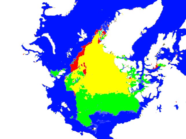
Green shows ice present in 2013 which was not present in 2012. Red shows the opposite.
COI | Centre for Ocean and Ice | Danmarks Meteorologiske Institut
Green shows ice present in 2013 which was not present in 2012. Red shows the opposite.

http://priuschat.com/threads/northeast-passage-2013.130889/page-3
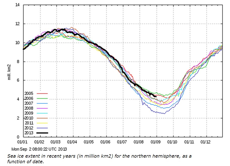
I linked to your Aug 25 post on Sea Ice.
Someone in the thread is calling you a liar.
DMI must be lying too, because they are showing the same thing.
Why don’t they bring their claims over here?
If you have a strong stomach, it is interesting to visit a post at “Climate Progress” from last March 23, and read how sure they were the ice would melt a lot this summer.
http://thinkprogress.org/climate/2013/03/23/1766011/ice-breaking-news-2013-arctic-freezing-season-not-what-its-cracked-up-to-be-literally/
It is interesting how they can look at the same things I look at and jump to different conclusions. One thing I’ve thought is that open water in the winter cools the Arctic Sea more than ice covered water can be cooled. The blogger “Tallbloke” was somehow allowed to make a comment stating a similar idea, to the great disgust of others who frequent the above site. Then air temperatures were around a degree cooler all summer up there. Hmm. I wonder what they think of “Tallbloke” now?
Looks like there is a chance of a storm moving right over the pole at the end of this week. (At least the models are seeing it, but we all know about models.) I think such a gale might actually increase ice extent, as the ice is packed tightly towards Alaska and a storm might spread it out like butter, and a “extent graph” doesn’t care if the ice that was 100% is spread out to 30%. That would create a slightly false impression, but might create a “bottom” to the extent graph two weeks early.
Also even a cold storm like that has a lot of uplift, and turns latent heat into available heat as vapor condenses into water and water freezes to snow, and that heat gets radiated out into space at the edge of the Stratosphere (low in the arctic,) and a colder snow falls. I think a storm in early August was a reason the “North Pole Camera” had temperatures down to minus 8 in mid-August.
I’m continueing my “North Pole Camera” observations at http://sunriseswansong.wordpress.com/2013/08/31/the-arctic-sea-ice-minimum-a-september-surprise/
Upcoming weather pattern, in about a week, is bringing higher pressure over the Canadian side and lower pressure over the Russian side. Ice gonna start moving in the other direction, toward the pole, for a time.