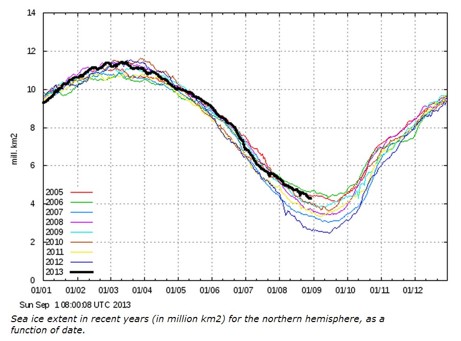
In June I started pointing out that 2013 Arctic ice was tracking a little below 2006, and received a huge amount of grief from our friends.
And now summer is over and the results are in.
COI | Centre for Ocean and Ice | Danmarks Meteorologiske Institut


Reblogged this on The Firewall.
We now know how big interannual variability can be,,,
We’re having some 2 mill km2 above 2012, another “little recovery” like this in 2014 and we’ll be above average at the end of the summer…
and AGW will be “a thing of the past”… 🙂
Seeing how TOO does not know when Summer starts for the Ice Trackers, S/HE/IT was wrong on both sides of the argument! ;).
.. s/he/it… LOL!!
The entire region of pack ice in the arctic is now consolidating. The open areas of 60-80% concentration MYI within the packice are now frozen over with new and young ice between the floes. Since the melt season is over for the Arctic Ocean seaice all first year ice which survived will now be multi-year ice; and all MYI is already snow-covered.
http://lance-modis.eosdis.nasa.gov/imagery/subsets/?subset=Arctic_r04c04.2013244.terra.250m
Glad you had they comment to hang on to. 😉
Our friends, who would gladly take the last penny from our pockets so they could continue to blather about the disaster that will never come.
Steve, but clearly T.O.O knows everything about all forms of ice. Particularly hail in New Mexico, which was a rare occurrence until the late 80’s. Odd that the huge jump in hail amount occurred at the exact same time as the observational network improved, but clearly that was a coincidence and there really wasn’t much hail before 1988.
-Scott
Actually, T.O.O was sort of right. Arctic ice did free fall right around the start of calendar summer. It proceeded to free fall for 2 weeks and then had average or below average melt pretty much every week after that.
-Scott
Hudson Bay melts out at the end of June every year, but it has no impact on the summer minimum.
Hudson Bay is OUTSIDE the Arctic Circle.
I just saw this site via Dr. Susan Crockford’s Polar Bear Science Blog
It has some brilliant images of the Beaufort Sea Ice month by month over recent years – easy to see how our Mainstream friends were so optimistic !!
http://alaska.usgs.gov/science/biology/polar_bears/previous_tracking.html
My name for the hurricane drought is ” The Great @Algore Grand Hurricane Minimum”
Oops messed up ” The @algore Grand Hurricane Minimum”..
right one
and because it’s a “grand minimum” it’s supposed to last for many decades!:-)
If the general freezing starts a little earlier this year we could have even more nice surprises, with the black curve going (possibly) above 2005-06 at the end of this month.