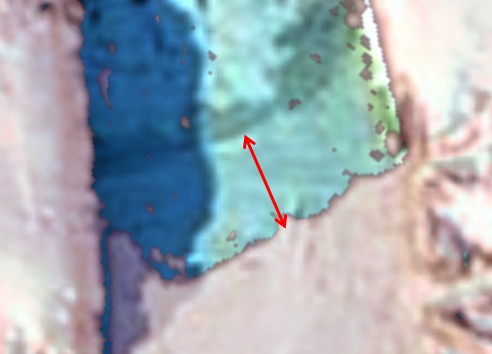
In 2010, our friends got hysterical about a block of ice which calved off the Petermann Glacier in Greenland. Since then, the glacier has grown 3km.
Disrupting the Borg is expensive and time consuming!
Google Search
-
Recent Posts
- Analyzing The Western Water Crisis
- Gaslighting 1924
- “Why Do You Resist?”
- Climate Attribution Model
- Fact Checking NASA
- Fact Checking Grok
- Fact Checking The New York Times
- New Visitech Features
- Ice-Free Arctic By 2014
- Debt-Free US Treasury Forecast
- Analyzing Big City Crime (Part 2)
- Analyzing Big City Crime
- UK Migration Caused By Global Warming
- Climate Attribution In Greece
- “Brown: ’50 days to save world'”
- The Catastrophic Influence of Bovine Methane Emissions on Extraterrestrial Climate Patterns
- Posting On X
- Seventeen Years Of Fun
- The Importance Of Good Tools
- Temperature Shifts At Blue Hill, MA
- CO2²
- Time Of Observation Bias
- Climate Scamming For Profit
- Climate Scamming For Profit
- Back To The Future
Recent Comments
- Bob G on Analyzing The Western Water Crisis
- Bob G on Analyzing The Western Water Crisis
- Bob G on Analyzing The Western Water Crisis
- arn on Analyzing The Western Water Crisis
- Scott Allen on Analyzing The Western Water Crisis
- conrad ziefle on Analyzing The Western Water Crisis
- conrad ziefle on Analyzing The Western Water Crisis
- Bob G on Analyzing The Western Water Crisis
- Bob G on Analyzing The Western Water Crisis
- Bob G on Gaslighting 1924


This will not do!!! Quick….adjust the data…er image…
So this glacier is doing its normal thing… advancing… breaking off chunks…repeat…I guess anything for “the cause”
Since the 2010 calving was the largest single area loss observed for Greenland it is reasonable to assume it last calved a big chunk before the satellite era; let’s say 1980. In that case may carry on growing for another 20+ years before another big chunk breaks off.
The chunk that broke off in 2010 was 275 km² and about 20km long so that fits with about 14 years of growth at the current rate.
My guess is there won’t be any more big chunks calving for at least 10 more years.
Petermann in 2003:
http://www.panoramio.com/photo_explorer#view=photo&position=7&with_photo_id=2716359&order=date_desc&user=283604
I’ve seen that photo too – on Google Earth. It’s a wrong caption. The glacier shown in that Panoramio photo is relatively small. It has a pronounced bend in it – and there is a bay full of islands just beyond its mouth (Qaanaaq Inlet?). I believe that one is located about 30km due east of Thule Airport.
The real Petermann glacier is much larger . . . http://www.huffingtonpost.com/2011/09/01/petermann-glacier-photos_n_945044.html
(Sorry if the link is to the dreaded HuffPo – but it is a good set of photos)
You’re right it’s the one that comes out at Kuinassuk. So much for Claus Halkjaer’s skill at map reading – and mine.
You might want to double check this. There was another large calving event in 2012. It was not not quite as large as the 2010 event. Both chunks broke off at lines of weakness that were clearly visible travelling down the glacier in aerial photographs dating back to 2000 (I haven’t been able to find anything older).
Last time I was able to look at it on the ‘Arctic.io’ site* there was a lot of sea ice disguising the actual terminus of the glacier. The glacier itself has marked longitudinal stripes, the sea ice does not.
*The area has been hidden by cloud for most of the past arctic summer, and then the ‘Arctic.io’ MODIS photo mosaic disappeared for most of August/September – just when things were getting intersting.