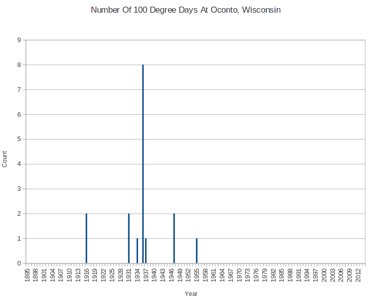
Someone was claiming last night that the high frequency of 100 degree readings during the 1930s was due to TOBS double counting. While I find it difficult to believe that anyone could be stupid and irresponsible enough to reset a Min/Max thermometer at the heat of the day, and then leave it until the next day – that isn’t the issue here.
I looked through the metadata for all of the stations in Wisconsin, and only found one which lists a morning time of observation for much of the 1930s. This should cause the temperatures to be recorded too low.
This what I found. They had quite a few 100 degree readings prior to 1960, and none since. Suppose they were double counting. What is two times zero? No matter how you look at, the 1930s was much hotter.
This is just my first shot across the lame TOBS excuse. I plan to generate lots more data.


If TOB existed in any meaningful way, would there have to be a significant number of high temperature pair days?
What does a diurnal curve look like?
The diurnal curve depends on the weather. Under clear skies and light winds the curve looks similar to the pulsatile blood flow in the big main arteries near the heart. A sharp ramp up, broad peak, slow initial decline that speeds up then slowly approaches the minimum. More time is spent near the minimum than the maximum, given ‘good’ weather.
Typical. Sunny. Day. and clear night. For starters.
PS. I missed placing the “/rhetorical” tag too. (Need to start using that one when I ask a question I already the answer to, but want to raise the issue in a little more subtle manner.)
Steve. An exercise worth looking into would be to check the adjusted data for stations with heat records in the past and see if the adjusted data still matches the record for the station or if the records now are standing marooned by the receeding historical temps. Since none of the adjustments are supposed to affect record tmax, this would serve as an independant verification of the adjustments if it is possible.
Food for thought.
USCRN has hourly data here. With daily accessible one folder up.
ftp://ftp.ncdc.noaa.gov/pub/data/uscrn/products/hourly02/
I did a small test using hourly readings of one year from one station in Alabama. At observation time I would do a 24 hour look back at the hourly max/min temperatures to find the 24 hour max/min. Did it for each hour from 5PM to midnight as observation time, That station’s average temperature dropped about 0.05C per hour when the yearly average for all hours are compared.
Small test, I know, but each hour was 0.03-0.06 lower than the previous. If you haven’t thought of it already you might want to try using their data.
In Obamaland, 2 x 0 = 100. Apparently his million man math is now affecting the climate sciences.
That’s part the government’s equation for defining the worth of a contract.
Only for welfare recipients and their cronies. SS gets the shaft (again).
Heh. Parody – Million Man Math Made Easy
(Not sure if i will play, but give it a try)
No, it says it is missing a codec. But I have heard it before. I am a Paul Shanklin fan.
Ah … showing the “ACELP.net” codec in media player here.
This codec pack downloadable from cnet would probably do it …
KLite Media Codec or VLC player cover “97%” of the codecs.
LaCrosse, WI has hourly data starting in 1933.
# of days of 100deg + during the 30’s:
6/33 – 3
7/36 – 9
8/36 – 2
As far as carryover, most of these temps peaked by 3pm and went under by 5 or 6pm. Most observing times were evening back then, and any carryover would have been minimal if protocols were observed. And as Tony and others have said, they were not necessarily adhered to due to common sense. And in July 36, most of those days were in a row.
Can we see an example from one of these days, that is, see the data from like noon through 6 PM?
June 20, 1933
12 – 95
1 – 99
2 – 101
3 – 100
4 – 100
5 – 100
6 – 97
June 27, 1933
12 – 95
1 – 98
2 – 100
3 – 103
4 – 101
5 – 96
6 – 92
June 30, 1933
12 – 94
1 – 96
2 – 98
3 – 100
4 – 99
5 – 99
6 – 99
Thank you.