When making fake data, always make sure it is consistently fake.
Gavin’s GISS data shows August 2011 at 0.69 anomaly, and August 2014 as 0.70 anomaly
data.giss.nasa.gov/gistemp/tabledata_v3/GLB.Ts+dSST.txt
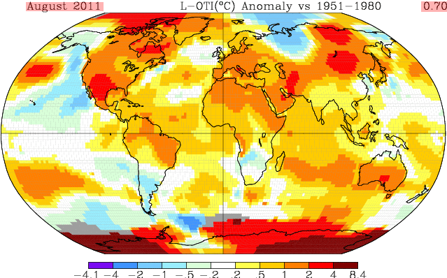
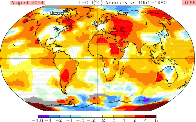
Unfortunately for him, his maps show 2011 as 0.70 and 2014 as 0.68.
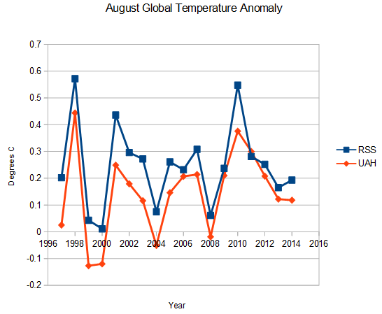
Gavin also might have wanted to cross check with some other people at NASA who showed August as second coldest of the last decade.
This scam makes Piltdown Mann look like legitimate science.


Now that is too funny! How DO they get away with this?
The regime’s propaganda minister backs him.
When are the responsible authorities going to frog march the twat Schmidt from his office and kick his sorry ass over the front door threshold !?
Prediction: Gavin will end up in prison the moment a Republican is elected President.
Not going to happen.
The DemiRats and ReBooblicans may put on a good dog and pony show for the public but behind close doors they scratch each others backs. link
A friend’s husband was in DC at a restaurant where Congressman and Senators eat. He was appalled to see several democrats and republicans sitting at the same table making fun of the dumb as rocks US voters.
“Rebooblicans” – I like that!
Perp walk, perp walk. What ya gonna do when they come for you?
Gavin, what Ya gonna do?
He explains how to understand the difference between the two different types of junk climate science.
https://twitter.com/ClimateOfGavin/status/512322087584026624
No real explanation about how any recent years are warmer than 1998.
“Gavin also might have wanted to cross check with some other people at NASA who showed August as second coldest of the last decade.”
Dr Christy and Dr Spencer are at the University of Alabama
“Dr. John R. Christy is the Distinguished Professor of Atmospheric Science and Director of the Earth System Science Center at the University of Alabama”
“Dr. Roy Spencer is a principal research scientist for the University of Alabama in Huntsville”
Dr Spencer is the U.S. Science Team leader for the Advanced Microwave Scanning Radiometer (AMSR-E) on NASA’s Aqua satellite. He has served as Senior Scientist for Climate Studies at NASA’s Marshall Space Flight Center.
In 1991 Dr Christy and Dr Spencer won the NASA Exceptional Scientific Achievement Medal
This particular Wiki has to be read to be Ummmm appreciated. Summer of Monuments
Looks like the tropical Hot Spot got a write over. About that missing hot spot
Almost all of the UAH team work for NASA
I have a question,
why do ‘Anomaly’ Graphs or Diagrams never Indicate a value for ‘0’.
Surely there must be a Value for ‘0’, otherwise ‘Anomaly’ Graphs are meaningless to me and other ‘Laymen’.
Are we all being ‘Conned’ by ‘Anomaly Graphs’?
Could you do a ‘Post’ on them?
I think there should be a NO to ‘0’ unless the Value Is stated.
Your eyes are getting heavier, you only hear the sound of official government data… you are getting warmer, you are getting warmer… give me your money now to prevent it from getting even warmer.. you are causing a disaster, you are causing a disaster… give money now. It’s worse than we thought.. all weather, whatever it is, is caused by global warming.. give money now… you are getting warmer…
ERRRrrr, then why am I sitting here drinking hot tea in flannels and a sweat shirt and shivering… in the sunny south (mid NC)
Cold flashes? 😉
Nah, usually just hot. (I HATE growing old.)
Again, we know Gavin embraces post ergo propter hoc adjustment as a valid scientific tool (heh, scientific tool!); why should we be surpassed that he adjust the past?
sorry, not “surpassed” rather “adjusted.”
surprised even?
Bob, help me understand this, as I do not. (Thanks)
Gavin stated…”For data sets with full coverage this should make no difference….but for data sets where there is missing data, there can be a small offset. In such cases the number in the index file should be considered definitive because (here is the part that makes no sense to me) the full time series is involved with filling in the data gaps, whereas on individual maps, only the data on that particular map is used to estimate the global mean.”
Yet the individual map data has been in-filled, and so the gaps no longer show, and are colored coded based on the same 1951 to 1980 anomaly. Is Gavin saying they show the gap color on the map, based on…” “For the maps we subdivide into regions…. and fill in any gaps by the mean in the available data in that region, and then get a global mean.” but they do not count that infilling in the number posted next to the map? This makes no sense. In order to fill in a particular color in the gap area, they had to assign a number to it. Perhaps Gavin is talking about the difference in the maps that leave the gaps blank, vs. the maps that are in-filled?
As to the gap filling in the index, why would they use the full time series to fill in the data gaps in the index? Does Gavin mean they do not use the current surrounding temperatures in the index, like they do in the maps, but use the mean of the entire time series for those surrounding areas, based on the average anomaly?
This would make no sense, as current temperatures in that anomaly area could be vastly different then the historic mean. Thus with the index area, you could get a reading completely wrong from the actual temperatures in that region. In which case the map method of using current surrounding temperatures would be superior to the index method that makes no sense.
Further thoughts / questions.
One would assume that the global mean anomaly base never changes, as it is based on the SAME past, 1951 to 1980 period. In other words the ANOMALY numbers in the index files and the ANOMALY numbers on the maps, should be based on the same IDENTICAL time period.
Now if the past anomaly basis, 1951 to 1980, is being changed, ( and they do continue to retroactively change the past) then current maps are being based against a different anomaly, EVEN IF IT IS THE SAME TIME PERIOD. (Indeed, if you were to retroactively cool that past ANOMALY BASE PERIOD, then new maps based on a different anomaly would appear warmer.) Which brings up a question… If they are CHANGING the past, does the base anomaly change?
Hi David, not sure there is much help I can give. I was just drawing attention to the fact that he felt the need to explain the differences.
It appears that there are many ways to fill in the missing parts of the map with inappropriate data, and some of these methods give different rank orderings. As Steve might say, with methodology like this, you can get whatever answer you want. Obviously he picked the one that makes this August the warmest.
There seems to be not a shred of qualitative or quantitative evidence to support the idea that this August was ‘hotter’ than 1998, or indeed hotter than many of the subsequent years..
Thanks Bob. I just have no idea why the “full time series” would be used to fill in gaps for a particular time period, when that period has surrounding current data which likely is more accurate then the “average”.
I also wonder how they determine what stations to use to spread into the gaps? Is it the mean anomaly of all the area 360 degrees around the gap? .
david ,you say ” Now if the past anomaly basis, 1951 to 1980, is being changed, ( and they do continue to retroactively change the past) then current maps are being based against a different anomaly, EVEN IF IT IS THE SAME TIME PERIOD. (Indeed, if you were to retroactively cool that past ANOMALY BASE PERIOD, then new maps based on a different anomaly would appear warmer.) ”
and this surprises you ? gavin is a heatophile,he will do whatever it takes to demonstrate warming. as steve has already shown the united states is cooling. eventually the reality of this cooling will lead to the loss of gavins job ,and the prestige (only in climate science circles these days) that goes with it.
gavin the heatophile will do all in his power to ensure this does not happen,at least until he reaches retirement,after which he will not care as he suns himself on his beach front terrace,safe in the knowledge sea level rise is not accelerating,reflecting over a career that contributed absolutely nothing,zero,nada to science nor humanity.
All very likely true, yet I would still like to know if, as they change the record for the anomaly period, do they ignore that change in doing future charts compared to it?
August in here in Scotland was cold – at least 2C below average, and we often had to light the wood stove in the evenings to keep the house warm. We had ice on our cabin roof on August 5th, and a proper ground frost on August 23rd, when grass froze and temperatures fell to 1C here and were sub-zero in Glen Lyon, a little further west. Similar sub zero temperatures were recorded in parts of Northern Ireland. According to the UK Met Office, the UK as a whole had an anomaly of -1.1C up to the 27th August – http://metofficenews.wordpress.com/2014/08/29/cool-wet-august-ends-fairly-average-summer/
I seem to remember clients from mainland Europe saying they had also had a cold August also. But for some reason none of this cold is shown on Gavin’s maps.
That is because all the heat concentrates in regions where there are few or no thermometers, such as Siberia, central Africa and South America or the polar regions.
Most children learn that when you tell a lie, you have to continue to tell more and to cover your previous lies. Eventually you lose track and get caught. Pathological liars fail to learn this lesson.
They would learn if there was somebody, anybody, that would hold them accountable in some punitive way.
People who convince themselves they play a historic role for mankind develop a sense of entitlement when it comes to moral codes, be they Communists, Greens or climate scientists. The end justifies the means.
We need to have a President again willing to say:
“But Dick, the alarmists do lie and steal and cheat, don’t they?”
Hottest August ever…not so fast according to satellite observations
http://vencoreweather.com/category/climate-info/
It is probably a good bet that 99.999% of all belly button lint that lands on the Greenland ice is buried under fresh snow or frost within hours. The color density of any non-white surface area surely approaches zero.
What we really need is international belly button lint inspectors. I am sure that the UN in conjunction with the WTO and World Bank (to receive the fines for having excess belly button lint) are already busy writing the draft “Guide to good
farming practicesbelly button lint inspection practices”…..It HAD to be the hottest Aug. ever. Duh. The big Climate shindig starts in a few days. Can’t have the last month on record be anything but really smokin’ hot. Easy dots to connect.