
Cross posted from my new blog : Saving West Virginia From Coal | Real Science
Greens hope to wreck the entire US like this mess off I-70 in West Virginia, in order to save them us from an essential trace gas.
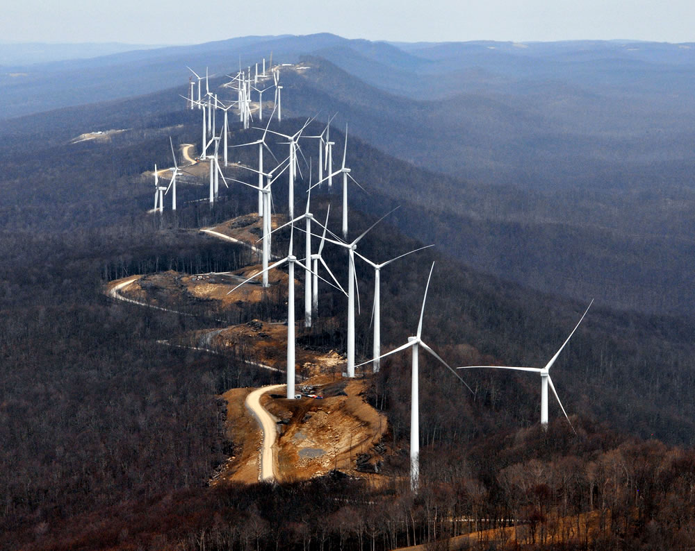
I drove past this disaster last week, and marveled about how stupid environmentalists have become.
Compare vs. coal which I filmed yesterday in Colorado

That first pic. Is that real? It looks photoshopped. Some of them look below the tree lines. If it’s real, WOW! That’s the ugliest scenery you could ever think of. It looks worse than if a nuclear blast had hit it.
It is real as far as I know. I drove past it last week. It was hideous.
The photo IS real, I took it during the construction of AES Laurel Mountain. The location, however is Elkins, WV. It wasn’t until after construction that we knew how bad an idea this project actually was.
But the Greenie/environMENTALists…… DO NOT CARE !!!
Does look like a fun road for a car or dirt bike rally. Perhaps that’s the idea.
The positioning of the towers seems totally arbitrary.
The photographic fore-shortening doesn’t help.
I suspect they would actually longitudinally fairly equally spaced.
Wind projects in mountaind have to conform to the mountains, not best practice. Turbines like these are closely spaced making them less efficient for winds coming up or down the ridgeline. Elkins is has a poor wind resourse and in summer these turbines often stand still.
From I-70? Driven it well over 100 times both ways usually taking I-70 through the tunnel in Wheeling and other times taking the I-470 by-pass south of town. That mess can’t be seen from either Steve. And this map of wind projects in WV doesn’t show any in the spike of WV. http://www.wvcommerce.org/App_Media/assets/doc/energy/WindMap_WEB.pdf
Now I-79 or I-68 may be a different story.
It might have been I-79 or I-68
Bet your referring to I-68. Easy enough to mix up since they split near Hancock MD where I-70 goes north into PA and junctions with the PA turnpike (I-76) at Breezewood, PA while I-68 goes through western MD then into WV and junctions with I-79 near Morgantown which takes one back north to junction with I-70 near Washington, PA not too far east of the WV line. So the question is did you drive the PA turnpike? If not then you took very hilly I-68 out of MD.
I don’t do the PA Turnpike.
I wouldn’t either if I wasn’t driving a big truck but that part of I-68 just makes driving miserable when your heavy. Lugging up the hills dropping sometimes below 30 mph and then working to keep from breaking the sound barrier going down the other side and on it goes over and over and over again. Believe me, it’s worth the toll on I-76 in those conditions. Especially since the company is paying for it and not me!
I always drive through Morgantown. I seem to remember that the wind farm was near the eastern continental divide.
Reblogged this on Climatism.
Sadly, it’s not photoshopped.
http://www.wsaz.com/news/headlines/Wind_Farm_Finally_Off_Ground_on_Laurel_Mountain_110434914.html
61 windmills to make 98 megawatts
I drive through WV twice a month following “corridor H” to my Ohio farm. Where coal mines were are parks and meadows…where these windmills (truly gigantic) loom it’s “war of the worlds” and no trespassing, dead birds, mountain tops closed forever.
Kurtz: “I hate them…I truly hate them…”
Just drove back from Spain. Ridge after ridge covered in windturbines. Some idle, some turning. Beautiful scenery destroyed forever.
I have and continue to see the same in the US during my travels as a truck driver. Along the 401 in Ontario. Along US 30 from Van Wert, OH to the Indiana state line. In Indiana along I-65 north of Indianapolis. In California on I-10 east of LA. Through the Valley north of Brownsville, TX. And many other places. Most the places I have mentioned are open flat land that had been cleared for agriculture long ago and not ridge lines though.
One reason the poorer parts of Appalachia are so poor is they have no flat land because the glaciers never got that far to round off the mountains and widen valleys. “Mountain top removal” mining is a boon to them. But only if you don’t “restore” the land to its previous unusable state.
So why is this “Mountain top removal” wind mining any different and gets an eco-nut pass?
You do know the answer to your own question of course.
Makes it very easy to understand why the Kennedy’s blocked having their view on Cape Cod looking like this view that has been imposed on the poor folks of West Virginia. I have no respect for folks who want to save the world at someone else’s expense.
I believe they’re planning to call it ‘Skyline Drive’.
Not only does the AES Laurel Mountain wind project, pictured above, look bad, in the first several months of operation this facility attracted and killed hundreds of migrating song birds one night. Before it was a year old, AES reported killing an endangered bat (or more) here. For the time being they shut down the turbines on spring, summer and fall nights, Not getting much return on OUR investment.
sick