
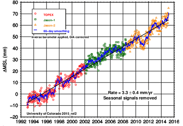
According to the University of Colorado, sea level is rising at 3.3 mm/year
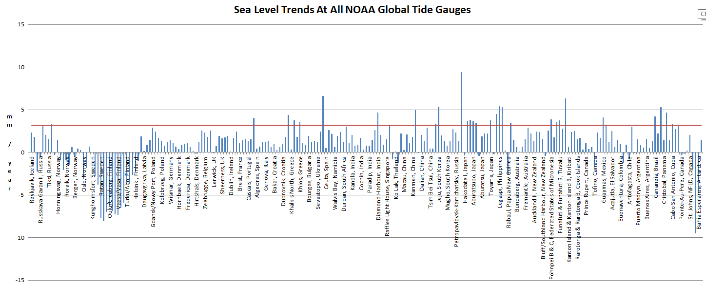
This is quite remarkable, because the average of all NOAA tide gauges is less than one third of that, at 1.01 mm/year. Eighty four percent of the tide gauges show lower rates than 3.3 mm/year. The median value is only 1.28 mm/year.
GlobalStationsLinearSeaLevelTrendsCSV.htm
In an actual field of science, this sort of huge discrepancy would concern the scientists. But climate science has nothing to do with science. It is propaganda.

But SG, you forgot to add in the 2.3mm/yr due to isostatic homogensation or something or other.. or was it tobs. gees, I forget which one is which.
Come on, you know there are “adjustments™” that have to be made before you get to AGW climate reality.
Thank you, Steven, for continuing to confront “consensus science” with reality!
I have seen the graph above so many times, and I expect that is what everybody is inclined to use in any discussion or referral. Bringing this into debate or discussion is very valuable. Going to send it to a few oceanic friends/acquaintances.
I am interested in the replies.
and of course, I have to check into the ‘homogenization’ procedures.
I’m not sure I’d be looking to Colorado for marine science.
I beg your pardon. We were all sea floor when Wisconsin didn’t have a beach. Our sea level experts know that what goes down must come up.
https://coloradowellington.files.wordpress.com/2015/05/colorado-in-late-cretaceous-92-mya.jpg
https://www.youtube.com/watch?v=NiXFq2266cg
Reblogged this on Centinel2012 and commented:
Just more Junk to add to the rest — they are hitting close to 100% Junk now — and after that we cross into the realm of magic.
Isn’t this the result of the sinking-sea-floor fudge?
That is a small part of it.
It is 2.8 before the modeled GIA adjustment. You cannot use a simple aggregate ot tide gauges because of tectoniks and isostatic rebound. Land does not stand still either. See essay PseudoPrecision for a more thoughtful analysis than this.
Less than 17% of the tide gauges show that much sea level rise, and all of those are due to subsidence.
Your argument is exactly backwards.
Ristvan,
I appreciate the balance you bring to a discussion.
But, I have two questions
Where is there specific, sound deduction of isostatic rebound values? and tectonics
Well, I think that is a very unsure measure in extrapolations forward and backward.
and the subsidence never seems to be entered into the calculations.
Secondly, would you be willing to read Steve Case below and comment?
I think he presents well grounded arguments.
So, how, exactly, does someone measure the level of the sea to 1/8th of an inch? Or is this level of precision a statistical fabrication, excessive significant figures, too many decimal points?
There are 233 records in that list, and 45 of them have negative rates of sea level rise, and you know what? Even if you throw all 43 of ’em out take the average of the remaining 188 it only comes to 1.9 mm/yr.
Well OK, I know there are a lot gauges in that list from Scandinavia where there’s a strong tectonic uplift tending to skew the results of any straight averaging. But I also know that you can grid the tide gauge data or average it up by coast lines or take the medians instead of averages and you still can’t get anywhere near the 3.3 mm/yr claimed by CU or the Church & White papers.
Besides that Colorado University over the last decade or so has re-written the data history to the point that what had been 2.6 mm/yr in 2004 is now 3.5 mm/yr. Here’s what that looks like:
http://oi59.tinypic.com/24e8482.jpg
Steve Case,
Thank you for the info. I appreciate it even if it means
I have to do more work.
Just one question. Did you take their two graphs and then plot or superimpose them
on the same sheet?
Well maybe two, What was your source for the info?
Colorado University’s data as it appeared in 2004:
http://web.archive.org/web/20040719102733/http://sealevel.colorado.edu/2004_rel1.2/sl_ib_ns_cu2004_rel1.2_global.txt
Colorado University’s data as it appears today:
http://sealevel.colorado.edu/files/2015_rel2/sl_ns_global.txt
In 2004
The slope from
1992.928 -4.489
to
2003.842 18.550
was 2.6 mm/yr
Today
the slope from
1992.9595 -5.818
to
2003.8459 27.779
is 3.5 mm/yr
Colorado University has re-written the data history to the tune of 0.9 mm/y over last ten years.
I should have labeled the red line 3.5 mm/yr at the 2004 point.
Thanks Steve, but certainly the SL adjustment was due to the time of observation. yes, sarc. BTW, do you have data from about 2006 or 2007 I recall some very flat years, then U of C going offline for months around then, and coming back with very different charts.
Steve, this is excellent work. Thank you for educating me!
Steve, I hope you don’t mind that I took the liberty of adding your graph to the entry on my “Resources” page about the U. of Colorado’s sealevel site:
http://sealevel.info/resources.html#colorado
Also, Steve, may I inquire as to your background?
You can inquire all you want.
Have some patience! Rep. Raúl Grijalva (D-AZ) will be writing you next week!
l thought that might be the nature of your reply 🙂
I ask because a second question would be to ask
if I might reference you in what I am presenting
wherever I might be doing so. Often times in High
schools or community things. My pay is usually a meal
or less.
I do not wish to be intrusive at all. But I wish to give
credit when and where I can.
My background is in chem/physics but after six years of off
and on study in various aspects of warming and related whatever
I have advanced from the babe in the woods to the toddler stage
and most college/ university types who profess to know much are
really not even at the crawling stage. It is really quite amazing.
darrylb May 11, 2015 at 3:46 am
I don’t have a PhD.
Here’s the unpublished story: In my region (Gulf of Maine), the REAL headline should be “A Decade Passes With NO Appreciable Rise in Sea Level.” Sea-Levels have actually dropped down to where they were in 2005!!! Not quite – they are actually 3mm lower!!!
In the last quarter century, Portland Maine’s tide gauge showed a 2 1/3 inch rise – a fair amount of variation – the long term (multi-decadal) trend still rising, but at a steady, un-accelerated rate for the past century.
The University of Colorado chart has absolutely no relevance here, and they get the GIA wrong too!!!
I never worked out how you could measure a change in the ocean to 1mm? From the surface or from space?
Even if the satellites are right, a rate of 3.3 +/- 0.4 mm/year is 13 +/- 1.6 inches/century.
Sea level has been rising at the present rate for the last 50 centuries so I would call that “Business As Usual”. So what is all the fuss about?
We lived on a sea-front point beside a lighthouse in 1946 and the highest [storm-free] tides of the year pretty well always covered the lawn by about an inch and if we didn’t maintain a levy bank around the well, the king tide would ruin the well water. The yard, lawn and well are exactly as they were those 69 years ago and in all recent-year observations guess where the highest tides now come?
Around 9 inches to a foot lower.
This is on the east coast of Australia in a tectonically stable part of the world which isn’t subject to post-glacial rebound. I have other similarly accurate but shorter term benchmarks [50 years] where the results are similar.
I know people in family little-ship maintenance businesses who would love to be enjoying sea level rise so they could handle bigger little-ships but no such luck.
You are speaking of real-world events and observations. That has no relevence to climate science.
There is a Gorilla in the corner regarding the sea level discussion. Ancient sunken cities off India’s coast, Japan, Egypt etc, etc. Some are quite deep; the city in India’s Gulf of Cambay is 36 meters deep (36,000 mm).
If it were somehow possible to melt all the ice on the planet at once, the sea would rise by 60 meters. So lets play their game to the end, ignoring basic arguements like ‘water freezes below zero celcius’, the tilt of Earth’s axis causing seasons and other such nonsense. It would take 20,000 years at today’s pace (by their math) to reach worst case. It looks like the ancients survived the iceage melt. i am guessing we could probably out run the catestrophic flood they are so worried about.
GC, my regular experience with satellite navigating accuracy is errors of hundreds of meters and lots of scepticism:
http://www.abc.net.au/news/2010-02-25/fatal-yacht-crash-inquiry-blames-gps/343272
And on a shoreline that is supposed to be sinking this is probably less than no SLR for the last 2000 years:
http://www.dailymail.co.uk/sciencetech/article-1066712/Uncovered-lost-beach-Romans-got-toehold-Britain.html
Your figure of 1.28 mm / yr. is very close to the 1.41 at the Honolulu tide gauge which I claim is a perfect location for the world-wide standard tide gauge.
http://tidesandcurrents.noaa.gov/sltrends/sltrends_station.shtml?stnid=1612340
No ice rebound, no continental shifting, island erosion and drift on the order of millions of years not hundreds, tide gauge is on a solid block of cooled lava on a volcanically inert island.
Err, the seafloor under the Hawaiian islands is constantly subsiding due to the geologically recent addition of the weight of the islands. This subsidence continues even when the volcanoes go dead.
Hidden in their FAQ page topics, Colorado University admit that they are purely concerned with sea volume and not with sea level relative to land
http://sealevel.colorado.edu/faq
I often wonder, but have never read of a figure, what effect undersea volcanic/geologic activity plays. if GIA can add a small offset to SLR, what is the effect of lava extrusion/sea floor rises. Is it really insignificant? For example, new islands have been formed and risen from sea floor to surface due to volcanoes. Earthquakes raise the sea floor (the huge sea quake back in 2004 near Sumatra raised a significant portion of the sea floor 1-2 meters). Even now I read of volcanic activity extruding lava off the US west coast. Or take this one in 2013.
http://www.dailymail.co.uk/news/article-2528892/Volcanic-island-coast-Japan-TRIPLES-IN-SIZE-fresh-undersea-eruptions.html
Surely such displacement of water must cause SLR of some magnitude? Or is it offset by subsidence elsewhere? I calculated that the 2004 sea quake would have added a greater than zero rise to sea level. Yes, only just greater than zero, but that was one event.
I’ve never seen any discussion of this before.
And I also wonder about Spangled Drongo’s comment. Near my hometown is a beach. I have seen photos of this beach from up to 100 years ago and it looks EXACTLY the same today. Sure, SLR of maybe 100-200mm over that time would not change things much, but surely some visual evidence must appear after that sort of time.
I wonder then whether people in various coastal locations can report obvious sea level rises on display locally? I would love to see a website of photos by people that show SLR – either the effect of it happening over time, or not.
Just because I wonder…
JoNova’s got a good piece on issue, suggesting, inter alia, that the study mixes satellite and tide gauge measurements, and that rate of change is 0.043 mm/yr, +/- 0.058 mm/yr—i.e., well within range of experimental error: http://bit.ly/1JGWQ9w It also mysteriously includes glacial isostatic adjustment (GIA), which adds another 3 mm/yr: http://bit.ly/1JGXdkq
Reblogged this on John Hargrove’s Weblog.