
Temperatures across the Arctic Ocean have turned very cold for this time of year, and melt has nearly stopped in the Arctic Basin
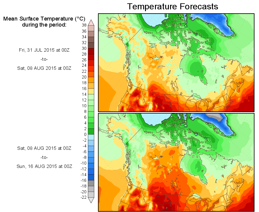
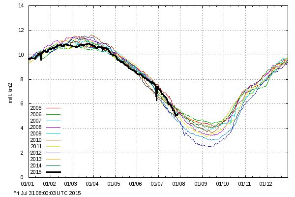
A storm in the Beaufort Sea is pushing thick ice towards the coasts, and causing extent to increase. Extent is continuing to track just below 2006, the year with the highest minimum of the past decade.
Most of the Arctic is covered with clouds, so the slow melt will continue.

“Crash and Burn” is not a phrase I would use to describe an aborted Arctic Melt season. But the point is taken.
This winter in the south polar vortex is strong. Evidence of this low pressure over the polar circle. This causes the cold air does not expand.
http://www.cpc.ncep.noaa.gov/products/stratosphere/strat-trop/gif_files/time_pres_HGT_ANOM_ALL_SH_2015.gif
At the same time the temperature drops above the polar circle. It anomalies.
http://www.cpc.ncep.noaa.gov/products/stratosphere/strat-trop/gif_files/time_pres_TEMP_ANOM_ALL_SH_2015.gif
Let’s see if the current decline in solar activity will result in anomalies.
Thanks, ren, for the reminders that solar activity influences Earth’s climate.
Thank you, Steven, for your patience and persistence in contrasting reality with AGW propaganda.
Weak solar wind and cosmic rays further increase at the poles.
http://sol.spacenvironment.net/raps_ops/current_files/rtimg/dose.15km.png
Ionizing radiation of galactic runs strongest from 10 to 30 km in the ozone zone.
Pressure over the Northern Polar Circle.
http://www.cpc.ncep.noaa.gov/products/stratosphere/strat-trop/gif_files/time_pres_HGT_ANOM_ALL_NH_2015.gif
Thanks, ren, for your persistence in reminding world leaders and their puppet scientists that they cannot ignore the giant fountain of energy Copernicus reported at the gravitational center of the solar system in 1543 !
https://www.youtube.com/watch?v=ROR0v3wi2X0
Thank you, ren, for the excellent video. Piers Corbyn is a good scientist. The Electric Universe idea explains many properties of the Sun that are ignored by the consensus science community and the Standard Solar Model of the Sun. I will post links to some of those observations that confirm the Electric Universe ideas.
However, the head of the Thunderbolts project seems to have little or no understanding of compressed nuclear matter in the Sun’s core and has refused to acknowledge:
1. The Sun’s pulsar core
2. Neutron repulsion as a source of solar energy
3. Solar wind H as a neutron-decay product
Again, thanks for this reminder of the electromagnetic connection between the Earth and the Sun.
These two papers confirm parts of the Electric Universe idea:
1. “Super-fluidity in the solar interior: Implications for solar eruptions and climate,” J. Fusion Energy 21, 193-198 (2002). http://www.springerlink.com/content/r2352635vv166363/
http://arxiv.org/pdf/astro-ph/0501441 http://www.omatumr.com/abstracts2003/jfe-superfluidity.pdf
2. “Observational confirmation of the Sun’s CNO cycle,” J. Fusion Energy (2006).
http://link.springer.com/article/10.1007%2Fs10894-006-9003-z
The Thundetbolt Project does not address the most basic nuclear physics flaw in Big Bang Cosmology, the Standard Solar Model and Nucleosynthesis:
The actual direction of nuclear evolution is exactly opposite that assumed: Neutrons become hydrogen atoms as the universe expands.
That’s interesting but complete bollox in relation to Steve’s post.
That has no effect on the amount of arctic melt this season It’s like being bitten by a midge as you are trampled by an elephant.
Andy
With a healthy El Nino and the warm blob south of Alaska, plus low solar activity, I am thinking that the winter could be a doozy in the Washington, DC general area, a lot like the Snowmaggedon year of 2009-10. That is when we had an 18″ snowstorm in December, then a 26″ snowstorm quickly folllowed by an 11″ snowstorm in February.
Right now Joe Bastardi’s guys project the band of highest snow fall this winter to be west of DC. From the Great lakes down through west and central NY and on down through the western 2/3rds of PA through most of WV and into eastern TN. http://www.weatherbell.com/saturday-summary-july-25-2015
So if that forecast is correct east to west travel is going to be a bear some times and places in NY like Syracuse that normally get a lot of snow anyway are really gonna get slammed.
Obviously this truck driver that wears groves the pavement of I-90, I-80 and I-70/76 between Indiana and points east quite a lot during the winter to cover the loads when other so called truck drivers wimp out is just thrilled with that forecast! [sarc].
Normally summer is my slower time but this year it’s busier than normal and it looks like this winter is going to be a ball buster.
grooves .
http://www.woodfortrees.org/plot/sidc-ssn/from:1972/to:2016/offset:10/trend/plot/sidc-ssn/from:1927/to:2016/plot/sidc-ssn/from:1927/to:1972/trend/plot/sidc-ssn/from:1927/to:2016/trend
Note that solar activity is at its lowest since the 87 year Gleissberg cycle
hence it is globally cooling…
But the Washington Post says it is SUPER HOT in India this week during the summer! So we are all doomed to roast like Equatorial India!
I will note here that not once did the Post mention all the cold records last winter even as blizzards blasted DC.
Watch out for the “real feel” trickery. For example, that Iran hot temperature of “163 F”? Here’s the story:
“The combination of an actual temperature of 115 F (46 C) and a dew point temperature of 90 F (32 C) pushed the apparent temperature to 163 F (73 C) Friday afternoon local time.”
Apparent temperature??? Really? The actual temperature was 115 F. Hot yes, but not unprecedented. I’ve also seen news articles which conflate “real feel” temperatures with past non-“real-feel” temperatures. Most low information lay persons are not going to figure out that there is a difference, and so are tricked into thinking that we really are burning up the planet…
About anyone in the US military that has served someplace where temperatures get up there knows about wet ball temps/heat index. Even back in 1980 when going through basic training at Ft. Jackson, SC during July the uniform was changed when what they now call the “real feel” temperatures got to a certain level. Despite those precautions we had one guy die of heat stroke and quite a few other heat injuries (heat cramps and heat exhaustion) in my training battalion the weeks I was there.
Later that year in September while going through jump school at Ft. Benning, GA they had metal troughs like those use to water livestock filled with ice water at certain training areas just in case.
I and several others suffered stage 1 hypothermia during phase one of the SF qualification course down at Ft. Bragg, NC that winter.
The fact is that despite the US military getting pretty active in trying to prevent environmental injuries and deaths they still happen. December of 1981 an SF soldier in 2nd Bn 10th SFG(A) died as a result of hypothermia in New England during winter training. Feb 1995 four Army Ranger trainees died in the Florida swamps of the Eglin AFB complex from hypothermia when a cold snap came through.
Any time you push service members to near the limits of their endurance and the weather turns there is a chance for the worst to happen. But it just has to be that way because no training comes close to the ultimate test they’re training for.
Current temps in India (12 noon): New Delhi 86°F, Mumbai 86°F, Chennai 90°F. Very typical for this time of year.
It was the Washington Post that originally uncovered Watergate ; just shows how far down the ethics ladder the Media has fallen. Wouldn’t you think more Media outlets, would openly challenge AGW claims,,, on the many failed predictions.
watergate = Nixon = GOP = Washington Post on it
It’s still the same….
Latitude is mostly right. The bulk of the fall in journalism happened between the Kennedy assassination and Watergate. But it gets more blatant as the years go by.
Since around the time of Watergate, the MSM ask first, “Who is helped, and who is hurt, by our reporting the truth?” And the answer usually determines whether they report it.
They have minority reports in the MSM, but they get more “minority” with each passing year. And even the minority tends to be controlled opposition.
During this same time period, “independent” media have gotten stronger, more effective, and more aware of deception. But by the same token, the more that their message conflicts with the MSM (i.e. the closer they get to the truth), the fewer eyeballs they tend to get, and moreover, the closer they get to being forcibly silenced. So you pays your money and takes your chances.
By that last comment I meant simply that you’ve got to play the hand you’re dealt, even if ultimately there’s no way to win with it. You already chosen to enter the game, so you’ve got to get on with it, either way. If you’re a publisher, you can choose either the mainstream route and restrict large amounts of truth, in the hope of reaching more people with little grains of truth. Or you can swing towards more truth, but reach far fewer people and also have a much lower chance of convincing them of anything.
Either way has an argument in favor of it, and neither gives especially promising results in the long run.
Remember this one? “A curious game [. . . .] The only winning move is not to play.”
RT
If anything those folks had to do with was about “truth” the Washington Post would have investigated and then exposed the Lewinsky affair. They and others knew about it well before Matt Drudge.
If it were about “truth” Hillary Clinton would have already been so humiliated by the Washington Post and others long ago concerning her antics with personal email and State Department bungling if not her our right dereliction of duty concerning Benghazi that she wouldn’t have even considered running for POTUS.
If it were about “truth” the WP and others would have been so all over the partisan political abuse by the IRS that by now some folks would be in jail and the obvious fact that it all leads back to the WH would have been front page news by now.
If it were about “truth” Armitage would have gone to jail instead of Scooter Libby and the IRS, Pigford, and other scandals having much greater import would have had at least equal coverage to the revelation of the identity of a third rate CIA agent. Etc, etc, etc, ad infinitum
Quite true, Rah!
That’s why they are in a hurry . The moment the general public understands that Global Warming Climate Change is a fraud they will realise that Big Government is about enslaving the people with lies.
I have a feeling Hansen knew about thermohaline circulation before most and indeed stifled Bill Gray’s research on it.
Amazing. Not the Arctic. It seems to be doing pretty much what it always does. Melts back in the summer, freezes solid in the winter. Yawn.
Amazing is the zombie AGW death-cult that will not die. How many times do the warmunists need to make bad predictions before the public figures out that, well, they were lying all along? How long before this massive fraud is defunded? Truly we are degenerate as a society to tolerate this rot.
“Amazing. Not the Arctic. It seems to be doing pretty much what it always does. Melts back in the summer, freezes solid in the winter. Yawn.”
Actually some of us find it very interesting, I have been posting on Steve’s blog for years on the matter. I can appreciate that some people find it as interesting as watching (white) paint dry.
I’d like to thank Steve ( Tony ) again for letting me post here even though we do not always meet eye to eye on Arctic data.
http://www.strategypage.com/gallery/images/coast-guard-selfie-07-2015.jpg
The Coast Guard Cutter Healy breaks through ice in the Arctic circle, July 14, 2015. This image was taken by an Aerostat, a self-contained, compact platform that can deploy multiple sensor payloads and other devices into the air. (U.S. Coast Guard photo)
I’m not convinced hanging on to 2006 is a good move to try and show Arctic sea ice extent is edging back to the good old days of the 1980’s. And that’s not me wanting it to be in a cyclic decline. So as they said 2013 would be ice free, i think, having watched ice decline on web sites since about 2008 or so, that it is hard to judge what the minima will be.
I think all indications will be this will not be a year that strikes any records for the minima, neither do I think it will be 2006 though. I might be proven wrong I do admit.
Andy
Andy,
I enjoy reading your opinions, as in previous years. At the start of the season I was thinking 2010’s values would be a reasonable estimate for the minimum this year (for all metrics really). I think that’s still a possibility, but it seems to me like there is a larger discrepancy between data sets this year, making it harder to get a handle on it.
-Scott
The 1980 famine in Karamoja, Uganda was, in terms of mortality rates, one of the worst in history. 21% of the population died, including 60% of the infants.[29] In the 1980s, large scale multilayer drought occurred in the Sudan and Sahelian regions of Africa.
https://en.wikipedia.org/wiki/Famine
the good old days of the 1980’s.
Just this morning – look at this crap ….
http://news.yahoo.com/tracking-retreat-arctic-ice-075453593.html
SMH
The cold in Beaufort Sea is blowing my mind, because I thought the “warm” spike in the PDO (AKA “The Blob”) would make that area warmer and the ice slushy and likely to break up easily. Of course, this is not the first time I’ve been wrong.
The maps our host posts at the start of this post suggest it will be between 0.0°C and -2.0°C over the Beaufort Sea, away from the shore, but it has been even colder. For the life of me I cannot figure out where the cold is coming from. Evaporative Cooling? The sun is up 24 hours a day, and it really should be thawing. Anyone have any ideas?
https://sunriseswansong.wordpress.com/2015/08/03/arctic-sea-ice-not-all-its-cracked-up-to-be/